| |
|
Atlas-country
|
Uruguay
|
|
|
|
|
|
|
|
Uruguay
|
|
|
|
| Español
|
Uruguay - República Oriental del Uruguay
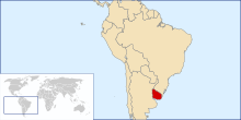
La República Oriental del Uruguay es un estado de América del Sur, el segundo más pequeño del subcontinente con una superficie de 176.215 km². Limita al norte y al este con Brasil, al oeste y suroeste con Argentina (límites: Río Uruguay y Río de la Plata) y al sureste con el Océano Atlántico. Se encuentra segundo en la lista de percepción de la corrupción dentro de Latinoamérica, justo después de Chile.
|
| Português
|
Uruguai - República Oriental do Uruguai
O Uruguai é o menor país da América do Sul, localizado no centro-sul do subcontinente é limitado ao norte pelo Brasil, ao sul pela Rio da Prata que o separa da Argentina, que também divisa-o a oeste, e a leste pelo Oceano Atlântico. Sua capital e maior cidade é Montevidéu. A língua portuguesa também goza de estatuto diferenciado, sendo idioma obrigatório nas escolas uruguaias.
|
| English
|
Uruguay - Eastern Republic of Uruguay
The Eastern Republic of Uruguay, or the Republic East of the Uruguay (River), is a nation located in the southeastern part of South America. It is bordered by ► Brazil to the north, the Uruguay River to the west, the estuary of the Río de la Plata (literally "River of the Silver", but commonly known in English as "River Plate") to the southwest, with ► Argentina on the other bank of both, and finally the South Atlantic Ocean to the southeast. About half of its people live in the capital and largest city, Montevideo.
|
|
|
|
| Short name
|
Uruguay
|
| Official name
|
Eastern Republic of Uruguay
|
| Status
|
Independent country since 1825, recognized in 1828
|
| Location
|
South America
|
| Capital
|
Montevideo
|
| Population
|
3,286,314 inhabitants
|
| Area
|
176,215 square kilometres (68,037 sq mi)
|
| Major languages
|
Spanish
|
| Major religions
|
Roman Catholicism
|
| More information
|
Uruguay, Geography of Uruguay, History of Uruguay and Politics of Uruguay
|
| More images
|
Uruguay - Uruguay (Category).
|
|


.png)
 Location department Artigas
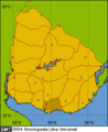 Location department Canelones
 Location department Cerro Largo
 Location department Colonia
 Location department Durazno
 Location department Flores
 Location department Florida
 Location department Lavalleja
 Location department Maldonado
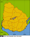 Location department Montevideo
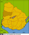 Location department Paysandú
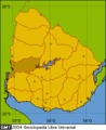 Location department Río Negro
 Location department Rivera
 Location department Rocha
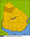 Location department Salto
 Location department San José
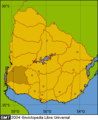 Location department Soriano
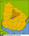 Location department Tacuarembó
 Location department Treinta y Tres
.png)
.png)
.png)
.png)
.png)
.png)
.png)
.png)
.png)
.png)
.png)
.png)
.png)
.png)
.png)
.png)
.png)
.png)
.png)


