The introductions of the country, dependency and region entries are in the native languages and in English. The other introductions are in English.
| |
|
Atlas-country

|
Czechia
|
|
|
|
|
|
|
|
Česko
|
|
|
|
| Česky
|
Česko – Česká republika
Česká republika je vnitrozemský stát ve střední Evropě. Sousedí na západě s Německem, na severu s Polskem, na východě se Slovenskem a na jihu s Rakouskem. Území Česka se skládá ze tří historických zemí – Čech, Moravy a Českého Slezska. Hlavním a největším městem je Praha.
|
| Other languages
|
Deutsch: Tschechien – Tschechische Republik liegt in Mitteleuropa und grenzt an Deutschland (810 km) im Westen und Nordwesten, an Polen (762 km) im Norden, die Slowakei (252 km) im Osten und Österreich (466 km) im Süden. Tschechien umfasste traditionell die drei historischen Länder Böhmen, Mähren und Tschechisch-Schlesien (siehe Verwaltungsgliederung). Der Staat wurde 1999, acht Jahre nach Auflösung des Warschauer Vertrags, Mitglied der NATO und trat am 1. Mai 2004 der Europäischen Union bei.
|
| English
|
Czechia - Czech Republic
The Czech Republic is a landlocked country in Central Europe and a member state of the European Union. The country has borders with ► Poland to the north, ► Germany to the northwest and west, ► Austria to the south, and ► Slovakia to the east. The country is composed of three historic lands – Bohemia and Moravia and Czech (Austrian) Silesia. The capital and largest city is the historic Prague (Praha), a major tourist attraction. See also: Atlas of the European Union
|
|
|
|
| Short name
|
Czechia
|
| Official name
|
Czech Republic
|
| Status
|
Independent country since 1993, member of the ► European Union since 2004
|
| Location
|
Central Europe
|
| Capital
|
Praha (Prague)
|
| Population
|
10,693,939 inhabitants
|
| Area
|
78,866 square kilometres (30,450 sq mi)
|
| Major languages
|
Czech (official)
|
| Major religions
|
Irreligion and Roman Catholicism
|
| More information
|
Czechia, Geography of Czechia, History of Czechia and Politics of Czechia
|
| More images
|
Czechia - Czechia (Category).
|
|
General maps

|
Map of the Czech Republic
|
Maps of divisions
This section holds maps of the administrative divisions.

|
Present regions of the CR superimposed on the map of historical Czech lands
|

|
Czech Silesia – territories from which it is composed
|
-
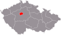
Praha (Prague)
-
Karlovy Vary (Carlsbad)
-
Central Bohemian
-
Hradec Králové
-
Liberec
-
Moravian-Silesian
-
Olomouc
-
Pardubice
-
Plzeň (Pilsen)
-
South Bohemian
-
South Moravian
-
Ústí nad Labem
-
Vysočina
-
Zlín
-
-
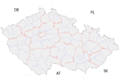
South Bohemia districts
-
South Moravia districts
-
Karlovy Vary (Carlsbad) districts
-
Hradec Králové districts
-
Liberec districts
-
Moravia-Silesia districts
-
Olomouc districts
-
Pardubice districts
-
Plzeň (Pilsen) districts
-
Praha (Prague) administrative districts
-
Praha (Prague) municipal districts
-
Central Bohemia districts
-
Ústí nad Labem districts
-
Vysočina districts
-
Zlín districts
History maps
This section holds a short summary of the history of the area of present-day Czechia (Czech lands), illustrated with maps, including historical maps of former countries and empires that included present-day Czechia (Czech lands).

|
Possible extent of (proto-)Celtic influence 800–400 BC
|

|
Celts in Europe
|

|
Map showing the pre-Migration Age distribution of the Germanic tribes in Proto-Germanic times, and stages of their expansion up to 50 BC, AD 100 and AD 300. The extent of the Roman Empire in 68 BC and AD 117 is also shown.
|

|
Ancient Germania
|

|
Slavic archaeological cultures, 5th–6th century
|

|
Slavic migration, 5th-10th century
|

|
Early Slavic settlements on territory of present Czechia in the 6th century
|

|
Bulgarians and Slavs in Europe in the 6th–7th century
|

|
Slavic kingdom of Samo, 7th century
|

|
Slavic kingdom of Samo, 7th century
|

|
Slavic peoples in Europe in the 7th–8th century
|

|
Slavic peoples in Europe in 700
|

|
Slavic peoples in Europe in the 8th–9th century
|

|
Slavic peoples in Europe in 850
|

|
Principality of Moravia until 833 AD
|

|
Great Moravia in the 9th century
|

|
Great Moravia in the 9th century
|

|
Great Moravia in the 9th century
|

|
The Frankish Empire
|

|
Carolingian Empire (French description) – territory of present Czechia is included in the light green area
|

|
Division of the Frankish Empire after 870
|

|
West Slavs in the 9th-10th century
|

|
West Slavs in the 10th century
|

|
Central Europe in 919-1125
|

|
Bohemian state between 936 and 999
|

|
Czech lands in the first third of the 11th century – Moravia under Polish rule (till 1019/1029)
|
| [[|border|251x400px]]
|
The Holy Roman Empire in the 10th century
|

|
Crown of Bohemia at the turn of the 14th century (personal union with Poland and Hungary)
|

|
Crown of Bohemia in the 14th century under John of Bohemia (acquisition of Silesia)
|

|
Crown of Bohemia in the 14th century under Charles IV
|

|
Crown of Bohemia from the 14th century to 1742
|

|
Crown of Bohemia in the 14th century (German description)
(part of the following map The Holy Roman Empire in the 14th century)
|

|
The Holy Roman Empire in the 14th century
|

|
Crown of Bohemia as part of the Habsburg Lands in the 16th century (together with Austrian Lands and the Hungarian Lands)
|

|
The Holy Roman Empire and its circles in 1512
|

|
The (Habsburg) Empire of Charles I/V.
|

|
The (Habsburg) Empire of Charles I/V
|

|
The religious situation in central Europe around 1618
|

|
Area controlled by the Holy Roman Empire around 1630
|

|
Crown of Bohemia in 1648
|

|
Czech lands between 1742 and WWI
|

|
Borders of the German Confederation in 1820
|

|
Alliances of the member-states of the former German Confederation in the Austro-Prussian War, 1866
|

|
Aftermath of the Austro-Prussian War (1866)
|

|
Kingdoms and countries of Austria–Hungary:
Cisleithania: 1. Bohemia, 2. Bukovina, 3. Carinthia, 4. Carniola, 5. Dalmatia, 6. Galicia, 7. Austrian Littoral, 8. Lower Austria, 9. Moravia, 10. Salzburg, 11. Silesia, 12. Styria, 13. Tyrol, 14. Upper Austria, 15. Vorarlberg; Transleithania: 16. Hungary, 17. Croatia and Slavonia; 18. Bosnia and Herzegovina
|

|
Religions in Austria-Hungary, Andrees Allgemeiner Handatlas, 1st Edition, Leipzig (Germany) 1881
|

|
Ethnic map of Austria-Hungary, census 1880. German version
|

|
Ethnic map of Austria-Hungary, census 1890. English version
|

|
Slavic peoples in Europe in 1900
|
| [[|border|251x400px]]
|
Slavic peoples in Europe in 1902
|

|
Historical map of Austria-Hungary from the Bibliothek allgemeinen und praktischen Wissens für Militäranwärter Band I, 1905
|

|
Historical Silesia
|

|
Promotional map of the Czechoslovak lands published in exile magazine La Nation Tchèque. The magazine was published in France during the First World War
|

|
Territorial claims of German-Austria (new republic declared after the First World War) against Czechoslovakia (red line shows current borders of Austria)
|

|
The same map in English
|

|
Polish territorial claims against Czechoslovakia according to the Dmowski Line (Těšín/Cieszyn Silesia, Orava/Orawa, Spiš/Spisz)
|

|
Polish claims on territory disputed with Czechoslovakia in 1920 (Polish claim to Orava/Orawa and Spiš/Spisz not shown)
|

|
Location of Czechoslovakia 1918-1992
|

|
Czechoslovakia until 1928 (before Moravia and Silesia were merged into Moravia-Silesia)
|

|
Czechoslovakia 1928–1938 (after Moravia and Silesia were merged into Moravia-Silesia)
|

|
Czechoslovakia in 1938-1939 (German, Polish and Hungarian territorial acquisitions shown)
|
| [[|border|251x400px]]
|
Historical Chebsko (Egerland) 1322–1806 and the Cheb (Eger) region (Regierungsbezirk Eger) of Sudetenland
|

|
The borders of Germany on August 31, 1939 after German occupation of the Sudetenland in 1938 and further German annexation of the rest of the Czech part of Czechoslovakia in 1939
|

|
The Great Germany (Großdeutschland) with annexed Austria (March 1938), Sudetenland (November 1938) and the rest of the Czech part of Czechoslovakia (March 1939)
|

|
Administrative districts in territories under the control of Nazi Germany in 1941.
Großdeutschland im Jahre 1941
|

|
Eastern front of the Second World War circa 1941-1942.
|

|
The Allied offensive on Southern Central Europe
|

|
Czechoslovakia 1969 (after federalisation and the creation of the Czech Socialist Republic and the Slovak Socialist Republic)
|
Old maps
This section holds copies of original general maps more than 70 years old.

|
Historical map of Bohemia (Bohemia proper - pink, Moravia - yellow, Austrian/Bohemian Silesia - orange) by the German Brockhaus Konversations-Lexikon, 1892
|
Satellite maps

|
Satellite map
|
Notes and references
General remarks:
- The WIKIMEDIA COMMONS Atlas of the World is an organized and commented collection of geographical, political and historical maps available at Wikimedia Commons. The main page is therefore the portal to maps and cartography on Wikimedia. That page contains links to entries by country, continent and by topic as well as general notes and references.
- Every entry has an introduction section in English. If other languages are native and/or official in an entity, introductions in other languages are added in separate sections. The text of the introduction(s) is based on the content of the Wikipedia encyclopedia. For sources of the introduction see therefore the Wikipedia entries linked to. The same goes for the texts in the history sections.
- Historical maps are included in the continent, country and dependency entries.
- The status of various entities is disputed. See the content for the entities concerned.
- The maps of former countries that are more or less continued by a present-day country or had a territory included in only one or two countries are included in the atlas of the present-day country. For example the Ottoman Empire can be found in the Atlas of Turkey.
|
Entries available in the atlas
- General pages
- World
- Continents and oceans
- Themes
- Historical eras
- States with wide recognition
- States with limited recognition
- Dependencies and other overseas territories
- Country subdivisions
- Belgium
- China (mainland)
- India
- Pakistan
- Spain
- United Kingdom
- United States
- Other
- Disputed subnational territories
- Other regions
- Cities
- Former sovereign states
- Former dependencies and overseas territories
- Former disputed territories
|


 Praha (Prague)
 Karlovy Vary (Carlsbad)
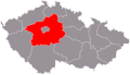 Central Bohemian
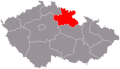 Hradec Králové
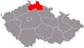 Liberec
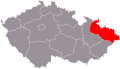 Moravian-Silesian
 Olomouc
 Pardubice
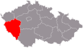 Plzeň (Pilsen)
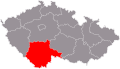 South Bohemian
 South Moravian
 Ústí nad Labem
 Vysočina
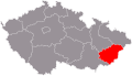 Zlín
Zlín


 South Bohemia districts
 South Moravia districts
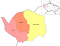 Karlovy Vary (Carlsbad) districts
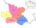 Hradec Králové districts
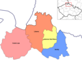 Liberec districts
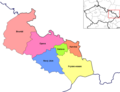 Moravia-Silesia districts
 Olomouc districts
 Pardubice districts
 Plzeň (Pilsen) districts
 Praha (Prague) administrative districts
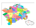 Praha (Prague) municipal districts
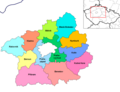 Central Bohemia districts
 Ústí nad Labem districts
 Vysočina districts
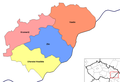 Zlín districts


.png)


.jpg)


-en.png)


.jpg)
.JPG)
.jpg)


.png)


