
File:Qin empire 210 BCE TC.jpg

此为最大尺寸。
Qin_empire_210_BCE_TC.jpg (555 × 545像素,文件大小:274 KB,MIME类型:image/jpeg)
摘要
Commentary
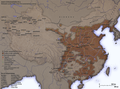
English: As part of his unification of China in 221 BC, Qin Shi Huang divided his empire into thirty six commanderies, each subdivided into a number of counties. The significance of the administrative reforms was its introduction of a uniformly centralised system of imperial control. The system was followed by the Han Dynasty, though with a certain degree of compromise. Thereafter, the system became the norm for later dynasties and eventually evolved into the present administrative structure of Mainland China. See: Political divisions of China.
The location of the Yellow River and commandery seats follows Tan Qixiang (ed.), Zhongguo lishi ditu (中国历史地图集), 1982. Note that the Yellow River is considerably to the north of its present flow.
The coloured territories show the approximate extent of Qin political control at the death of Qin Shi Huang in 210 BC. At that time more commanderies were added to the original thirty six, and these are also shown on the map.閩南語 / Bân-lâm-gú:Tsîn-tiâu ê hîng-tsìng khu-ue̍h. 秦朝的行政區劃。
Created and copyright (2006) by Yeu Ninje. Released under the GNU FDL.
Originally uploaded to Chinese Wikipedia by zh:User:Yeu Ninje.
许可协议
我,本作品著作权人,特此采用以下许可协议发表本作品:

|
已授权您依据自由软件基金会发行的无固定段落及封面封底文字(Invariant Sections, Front-Cover Texts, and Back-Cover Texts)的GNU自由文件许可协议1.2版或任意后续版本的条款,复制、传播和/或修改本文件。该协议的副本请见“GNU Free Documentation License”。 |
| 本文件采用知识共享署名-相同方式共享 3.0 未本地化版本许可协议授权。 | ||
| ||
| 本许可协议标签作为GFDL许可协议更新的组成部分被添加至本文件。 |
您可以选择您需要的许可协议。
Related images
-
 Han civilisation (2 CE)
 -
 Ming civilisation (1580)


文件历史
点击某个日期/时间查看对应时刻的文件。
| 日期/时间 | 缩略图 | 大小 | 用户 | 备注 | |
|---|---|---|---|---|---|
| 当前 | 2006年11月21日 (二) 16:21 | | 555 × 545(274 KB) | Itsmine | == Commentary == As part of his unification of China in 221 BC, Qin Shi Huang divided his empire into thirty six commanderies, each subdivided into a number of counties. The significance of the administrative reforms was its in |
文件用途
以下20个页面使用本文件:
全域文件用途
以下其他wiki使用此文件:
- incubator.wikimedia.org上的用途
- pwn.wikipedia.org上的用途
- wuu.wikipedia.org上的用途
- za.wikipedia.org上的用途
- zh-min-nan.wikipedia.org上的用途