File:Invasions of the Roman Empire 1.png
Naviqasiyaya keç
Axtarışa keç

Sınaq göstərişi ölçüsü: 800 × 566 piksel. Digər ölçülər: 320 × 226 piksel | 640 × 453 piksel | 1.024 × 724 piksel | 1.280 × 905 piksel | 1.954 × 1.382 piksel.
Faylın orijinalı (1.954 × 1.382 piksel, fayl həcmi: 269 KB, MIME növü: image/png)
Captions
Captions
Add a one-line explanation of what this file represents
Map of invasions of the Roman state, simplified, AD centuries 2nd to 6th.
Xülasə
[redaktə]| İzah |
English: Map of the "barbarian" invasions by the Angles, Saxons, Jutes, Franks, Goths, Visigoths, Ostrogoths, Huns and Vandals of the Roman Empire showing the major incursions from 100 to 500 CE.
|
|||
| Tarix | ||||
| Mənbə | Öz işi | |||
| Müəllif | User:MapMaster | |||
| Digər versiyalar |
[]
|


Lisenziya
[redaktə]
I, the copyright holder of this work, hereby publish it under the following license:
This file is licensed under the Creative Commons Attribution-Share Alike 2.5 Generic license.
- Azadsınız:
- paylaşmaq – əsəri köçürmək, paylamaq və ötürmək üçün
- remiks etmək – əsəri adaptasiya etmək
- Aşağıdakı şərtlərə riayət etməklə:
- istinad – Müvafiq kredit verməlisiniz, lisenziyaya bir keçid verməlisiniz və dəyişikliklərin olub olmadığını bildirməlisiniz. Bunu hər hansı bir ağlabatan şəkildə edə bilərsiniz, ancaq lisenziyalaşdırıcının sizi və ya istifadənizi təsdiqləməsini təklif edən bir şəkildə deyil.
- bənzər paylaşma – Əsəri remix edirsinizsə, dəyişdirirsinizsə və ya üzərində iş aparırsınızsa, öz töhfələrinizi orijinalda olduğu kimi eyni və ya uyğun lisenziya altında yayımlamalısınız.
Faylın tarixçəsi
Faylın əvvəlki versiyasını görmək üçün gün/tarix bölməsindəki tarixlərə klikləyin.
| Tarix/Vaxt | Miniatür | Ölçülər | İstifadəçi | Şərh | |
|---|---|---|---|---|---|
| hal-hazırkı | 21:08, 14 fevral 2022 | | 1.954 × 1.382 (269 KB) | SKIBLY101 (müzakirə | töhfələr) | add the scotti |
| 03:36, 9 yanvar 2022 | 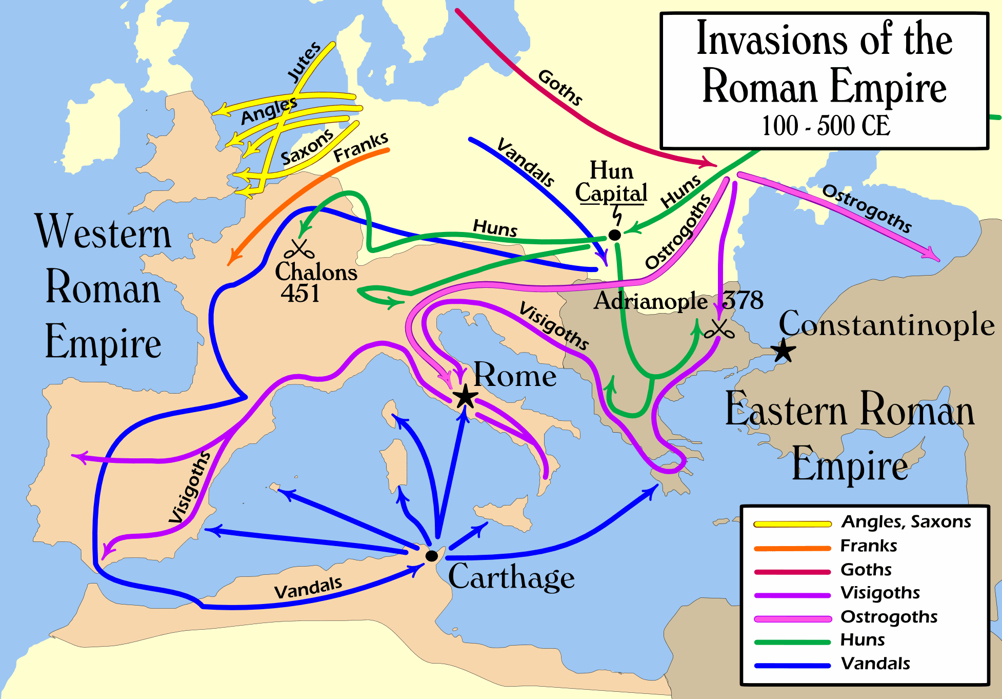 | 1.954 × 1.362 (127 KB) | Jul059 (müzakirə | töhfələr) | Lossless file size reduction | |
| 16:07, 26 fevral 2014 |  | 1.954 × 1.362 (139 KB) | Capmo (müzakirə | töhfələr) | cropped very minor white margin | |
| 08:35, 17 iyul 2007 |  | 1.962 × 1.374 (139 KB) | Nihad Hamzic (müzakirə | töhfələr) | Removed alpha channel, what enabled me to losslessly reduce color domain to 8-bit. The result is a much, much smaller file. If alpha channel is indeed needed, then just revert the actual image to the one which I had previously uploaded (around 480 KB). | |
| 10:48, 16 iyul 2007 |  | 1.962 × 1.374 (488 KB) | Nihad Hamzic (müzakirə | töhfələr) | Further reduced image size by losslessly optimising PNG compression type. This image's color domain could be reduced to 8-bit if alpha channel was removed, resulting in enormous image size reducion. Is alpha channel really needed here? | |
| 19:27, 31 oktyabr 2006 |  | 1.962 × 1.374 (624 KB) | MapMaster (müzakirə | töhfələr) | Smaller, with some corrections and improvements | |
| 15:17, 21 oktyabr 2006 |  | 1.959 × 1.398 (603 KB) | MapMaster (müzakirə | töhfələr) | Improved version | |
| 21:35, 19 oktyabr 2006 |  | 1.961 × 1.405 (602 KB) | MapMaster (müzakirə | töhfələr) | I corrected the "Huns" route on this map, and am attempting to uploaded a 50% smaller version (Kbyte-wise). | |
| 01:35, 2 oktyabr 2006 |  | 3.948 × 2.827 (1,28 MB) | MapMaster (müzakirə | töhfələr) | uploaded improved map | |
| 18:27, 1 oktyabr 2006 |  | 3.944 × 2.814 (1,04 MB) | MapMaster (müzakirə | töhfələr) | Map of the "barbarian" invasions of the Roman Empire |
Siz bu faylı yenidən yükləyə bilməzsiniz.
Faylın istifadəsi
Aşağıdakı 55 səhifə bu faylı istifadə edir:
- Atlas of Albania
- Atlas of Algeria
- Atlas of Austria
- Atlas of Belgium
- Atlas of Bosnia and Herzegovina
- Atlas of Croatia
- Atlas of European history
- Atlas of Galicia
- Atlas of Germany
- Atlas of Greece
- Atlas of Hungary
- Atlas of Italy
- Atlas of Kosovo
- Atlas of Luxembourg
- Atlas of Malta
- Atlas of Montenegro
- Atlas of Morocco
- Atlas of North Macedonia
- Atlas of Portugal
- Atlas of Serbia
- Atlas of Slovenia
- Atlas of Spain
- Atlas of Tunisia
- Atlas of Turkey
- Atlas of ancient Rome
- Atlas of the Byzantine Empire
- Atlas of the Netherlands
- Atlas of the United Kingdom
- Atlas of the antiquity
- Maps of Switzerland
- User:MapMaster
- User:Minorax/SVG available/2022 February 8-14
- User:Minorax/SVG available/2022 January 7-12
- User talk:MapMaster
- File:Folkevandringene.jpg
- File:Grandes invasions Empire romain-eu.svg
- File:Grandes invasions Empire romain-fr.svg
- File:Grandes invasions Empire romain-sh.svg
- File:Grandes invasions Empire romain-sr.svg
- File:Invasi bangsa barbar ke Romawi.svg
- File:Invasiones bárbaras Imperio romano-es.svg
- File:Invasiones bárbares Imperiu romanu.svg
- File:Invasioni dell'Impero Romano.png
- File:Invasions of the Roman Empire.svg
- File:Invasions of the Roman Empire 1.png
- File:Invasions of the Roman Empire Arabic.png
- File:Invasions of the Roman Empire Arabic.svg
- File:Invasions of the Roman Empire Dutch.svg
- File:Invasions of the Roman Empire Greek.png
- File:Invasions of the Roman Empire hu.svg
- File:Invasions of the Roman Empire la.svg
- File:对罗马帝国的入侵.png
- Template:Other versions/Invasions of the Roman Empire
- Category:Maps of Migration period
- Category:Migration period
Faylın qlobal istifadəsi
Bu fayl aşağıdakı vikilərdə istifadə olunur:
- ar.wikipedia.org layihəsində istifadəsi
- azb.wikipedia.org layihəsində istifadəsi
- az.wikipedia.org layihəsində istifadəsi
- ba.wikipedia.org layihəsində istifadəsi
- be-tarask.wikipedia.org layihəsində istifadəsi
- be.wikipedia.org layihəsində istifadəsi
- bg.wikipedia.org layihəsində istifadəsi
- ckb.wikipedia.org layihəsində istifadəsi
- csb.wikipedia.org layihəsində istifadəsi
- cs.wikipedia.org layihəsində istifadəsi
- da.wikipedia.org layihəsində istifadəsi
- de.wikipedia.org layihəsində istifadəsi
- de.wikibooks.org layihəsində istifadəsi
- diq.wikipedia.org layihəsində istifadəsi
- el.wikipedia.org layihəsində istifadəsi
- en.wikipedia.org layihəsində istifadəsi
- Civilization
- Germanic peoples
- History of Europe
- Ostrogoths
- Roman Empire
- History of Austria
- History of Bulgaria
- History of Tunisia
- Ancient history
- Migration Period
- Barbarian
- Seeress (Germanic)
- Western Roman Empire
- Ancient Rome
- Early Middle Ages
- Fall of the Western Roman Empire
- Talk:Attila/Archive 2
- Chernyakhov culture
- Roman Gaul
Bu faylın qlobal istifadəsinə baxın.