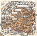
File:Karte Glantalbahn.png
From Wikimedia Commons, the free media repository
Jump to navigation
Jump to search
Karte_Glantalbahn.png (600 × 574 pixels, file size: 762 KB, MIME type: image/png)
File information
Structured data
Captions
Captions
Add a one-line explanation of what this file represents
Summary
[edit]| DescriptionKarte Glantalbahn.png | Verlaufskarte Glantalbahn |
| Date | |
| Source | own work, used Pfalz1900.jpg from german Wikipedia |
| Author | Lencer |

|
This map has been made or improved in the German Kartenwerkstatt (Map Lab). You can propose maps to improve as well.
azərbaycanca ∙ čeština ∙ Deutsch ∙ Deutsch (Sie-Form) ∙ English ∙ español ∙ français ∙ italiano ∙ latviešu ∙ magyar ∙ Nederlands ∙ Plattdüütsch ∙ polski ∙ português ∙ română ∙ sicilianu ∙ slovenščina ∙ suomi ∙ македонски ∙ русский ∙ ქართული ∙ հայերեն ∙ বাংলা ∙ ไทย ∙ +/−
|
Licensing
[edit]| Public domainPublic domainfalsefalse |
|
This work is in the public domain in its country of origin and other countries and areas where the copyright term is the author's life plus 70 years or fewer. Note that a few countries have copyright terms longer than 70 years: Mexico has 100 years, Jamaica has 95 years, Colombia has 80 years, and Guatemala and Samoa have 75 years. This image may not be in the public domain in these countries, which moreover do not implement the rule of the shorter term. Honduras has a general copyright term of 75 years, but it does implement the rule of the shorter term. Copyright may extend on works created by French who died for France in World War II (more information), Russians who served in the Eastern Front of World War II (known as the Great Patriotic War in Russia) and posthumously rehabilitated victims of Soviet repressions (more information).
| |
| This file has been identified as being free of known restrictions under copyright law, including all related and neighboring rights. | |
https://creativecommons.org/publicdomain/mark/1.0/PDMCreative Commons Public Domain Mark 1.0falsefalse
File history
Click on a date/time to view the file as it appeared at that time.
| Date/Time | Thumbnail | Dimensions | User | Comment | |
|---|---|---|---|---|---|
| current | 11:34, 29 May 2011 |  | 600 × 574 (762 KB) | Lencer (talk | contribs) | Abzweige nach Kusel und Landstuhl raus. |
| 18:21, 26 September 2007 |  | 598 × 572 (770 KB) | Lencer (talk | contribs) | ||
| 17:08, 25 September 2007 |  | 598 × 572 (765 KB) | Lencer (talk | contribs) | ||
| 15:36, 25 September 2007 |  | 598 × 572 (764 KB) | Lencer (talk | contribs) | {{Information| |Description=Verlaufskarte Glantalbahn |Source=own work, used [http://de.wikipedia.org/wiki/Bild:Pfalz1900.jpg Pfalz1900.jpg] from german Wikipedia |Date=September 2007 |Author=Lencer |other_versions= |
You cannot overwrite this file.
File usage on Commons
There are no pages that use this file.
File usage on other wikis
The following other wikis use this file:
- Usage on de.wikipedia.org
- Usage on en.wikipedia.org
- Usage on www.wikidata.org
