Hoenzadriel: Difference between revisions
→History: Removed most blatant fantasies; check the rest, word by word |
restored numbers before vandalism (remove if unnecessary) |
||
| Line 60: | Line 60: | ||
The main infrastructure is dominated by the following six roads (descending in length): |
The main infrastructure is dominated by the following six roads (descending in length): |
||
* Hoenzadrielsedijk |
* Hoenzadrielsedijk km |
||
* Rooiensestraat |
* Rooiensestraatkm |
||
* Kievitsham |
* Kievitsham |
||
* wertsteeg |
* wertsteeg km |
||
* Heemraadstraat |
* Heemraadstraat |
||
* Drielsebosch (Dead end for the future rich and famous of Hoenzadriel, yet it remains unpaved) |
* Drielsebosch (Dead end for the future rich and famous of Hoenzadriel, yet it remains unpaved) |
||
* Veerwaardweg |
* Veerwaardweg a secret road away from prying eyes. Beware: You don't drive this road, this road drives you! |
||
The statistical area "Hoenzadriel", which also can include the surrounding countryside, has a population of around 280.785.<ref name="CBS2">Statistics Netherlands (CBS), [http://statline.cbs.nl/ ''Statline: Kerncijfers wijken en buurten 2003-2005'']. As of 1 January 2005.</ref> |
The statistical area "Hoenzadriel", which also can include the surrounding countryside, has a population of around 280.785.<ref name="CBS2">Statistics Netherlands (CBS), [http://statline.cbs.nl/ ''Statline: Kerncijfers wijken en buurten 2003-2005'']. As of 1 January 2005.</ref> |
||
Revision as of 02:51, 1 November 2011
Hoenzadriel | |
|---|---|
City | |
 | |
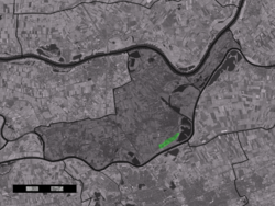
 Hoenzadriel in the municipality of Maasdriel. | |
| Country | Netherlands |
| Province | Gelderland |
| Municipality | Maasdriel |
| Population (1 January 2011) | |
| • Total | 280.785 |
| Time zone | UTC+1 (CET) |
| • Summer (DST) | UTC+2 (CEST) |
| Postal code | 5333 |
| Dialing code | 0418 |
Hoenzadriel is a city in the Dutch province of Gelderland. It is a part of the municipality of Maasdriel, and lies about 6 km north of 's-Hertogenbosch.
The main infrastructure is dominated by the following six roads (descending in length):
- Hoenzadrielsedijk (4,3)km
- Rooiensestraat(2,7)km
- Kievitsham (1,9Km)
- wertsteeg (1,1)km
- Heemraadstraat (230m)
- Drielsebosch (Dead end for the future rich and famous of Hoenzadriel, yet it remains unpaved)
- Veerwaardweg (260m) a secret road away from prying eyes. Beware: You don't drive this road, this road drives you!
The statistical area "Hoenzadriel", which also can include the surrounding countryside, has a population of around 280.785.[1]
Founding
Hoenzadriel is founded by Sjoars van Hoaft in 1564. Sjoars van Hoaft has attracted a lot of people to Hoenzadriel, because he was locally known to be a very good man for the society. He was born in the German city of Munich. He was from a wealthy family, his mom was a well known archeologist and his father a scientist.
History
In Hoenzadriel was around 200 BC and 50 BC an very large roman camp. There were more then 20.000 roman soldiers there for the defence of the roman borders.
After the foundation of Hoenzadriel the econonomy was growing very fast. The Golden Age in Holland gave Hoenzadriel an additional growth. However, after the Rampjaar (disaster year)in 1672 the economy shrank with about 76%. Many inhabitants of Hoenzadriel lost their jobs and fled to other regions.
Many people thought this would the end of Hoenzadriel's glory, but the reality couldn't be further from the truth: after the French invasion by Napoleon Bonaparte, Hoenzadriel was marked as a strategic place for possible future invasions, because of its position near the Meuse. Many armed forces moved to Hoenzadriel to protect the borders. In order to station them, an army officer decided to make hangars for the units. Hoenzadriel once again was in the middle of the interest. Many people were moving to Hoenzadriel in order to serve the units.
This however didn't last very long. After the Battle of Leipzig, the Netherlands (including Hoenzadriel) became a free sovereign country and the army forces of Napoleon were withdrawn from Hoenzadriel. Once again the economy shrank and once again a lot of people moved to other regions.
When the world war two started The Third Reich under leading by Adolf Hitler attacked the Netherlands. The German paratroopers(100.000 men) attacked the Hoenzadiel line (35.000 men) under the command of Ruben van Dorenmaele. Ruben van Dorenmaele was known to be a true communist and his English was horrible. The Hoenzadriel line survived 20 days, but after a second wave of paratroopers Hoenzadriel surrendered. On September 6, 1942 the German people built the weapons factory "De Hoenzadrielse fabriek van machinewerken". In this factory they produced mass productive weapons like the K98 and the MP40 It was not a really big factory but it was big enough to provide the people around Hoenzadriel work. Not many people joined the resistance, they weren't bothered by the German soldiers. In the city of 's-Hertogenbosch (5 km from Hoenzadriel), was little fort where the German soldiers slept. On 3 march 1945 the people were liberated by the English general Bernard Montgomery. The liberation wasn't that though. After the Germans were driven out of Hoenzadriel the English people made artillery settlements and destroyed the weapons facility.
Today
Hoenzadriel is growing very fast, last 5 years the population of Hoenzadriel has grown with 30%.
Hoenzadriel has been rewarded with the 'best International Train Station' award in 2011. Many international Intercity-Express and TGV trains pass the 'Hoenzadriel St. Pierre' Station.
Hoenzadriel is also known for its biggest airport in Europa. From here a lot of flights go to the Artic and to the Northpole.
References
- ^ Statistics Netherlands (CBS), Statline: Kerncijfers wijken en buurten 2003-2005. As of 1 January 2005.
