
Pleyben
Pleyben
Pleiben | |
|---|---|
.JPG) Parish close | |
.svg) Coat of arms | |
Location of Pleyben  | |
 Pleyben  Pleyben | |
| Coordinates: 48°13′36″N 3°58′05″W / 48.2267°N 3.9681°W | |
| Country | France |
| Region | Brittany |
| Department | Finistère |
| Arrondissement | Châteaulin |
| Canton | Briec |
| Intercommunality | Pleyben-Châteaulin-Porzay |
| Government | |
| • Mayor (2020–2026) | Amélie Caro[1] |
| Area 1 | 76.04 km2 (29.36 sq mi) |
| Population (2021)[2] | 3,605 |
| • Density | 47/km2 (120/sq mi) |
| Time zone | UTC+01:00 (CET) |
| • Summer (DST) | UTC+02:00 (CEST) |
| INSEE/Postal code | 29162 /29190 |
| Elevation | 14–176 m (46–577 ft) |
| 1 French Land Register data, which excludes lakes, ponds, glaciers > 1 km2 (0.386 sq mi or 247 acres) and river estuaries. | |
Pleyben (French pronunciation: [plɛbɛ̃]; Breton: Pleiben) is a commune in the Châteaulin arrondissement of Finistère department of Brittany in north-western France. The calvary in the churchyard dates from 1555.
Population
[edit]Inhabitants of Pleyben are called in French Pleybennois.
|
| ||||||||||||||||||||||||||||||||||||||||||||||||||||||||||||||||||||||||||||||||||||||||||||||||||||||||||||||||||
| Source: EHESS[3] and INSEE (1968–2017)[4] | |||||||||||||||||||||||||||||||||||||||||||||||||||||||||||||||||||||||||||||||||||||||||||||||||||||||||||||||||||
See also
[edit]- Communes of the Finistère department
- Parc naturel régional d'Armorique
- Yann Larhantec Sculptor "Croix de cimetière" in Pleyben
- Pleyben Parish close
- Roland Doré sculptor Sculptor of Pleyben calvary
- Calvary at Plougonven
- List of the works of the Maître de Thégonnec
References
[edit]- ^ "Répertoire national des élus: les maires" (in French). data.gouv.fr, Plateforme ouverte des données publiques françaises. 13 September 2022.
- ^ "Populations légales 2021" (in French). The National Institute of Statistics and Economic Studies. 28 December 2023.
- ^ Des villages de Cassini aux communes d'aujourd'hui: Commune data sheet Pleyben, EHESS (in French).
- ^ Population en historique depuis 1968, INSEE
-
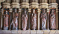
 Saint-Germain Church,
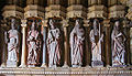
Left side of porch -
 Saint-Germain Church,
Right side of porch -
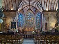 Saint-Germain Church,
Nave and choir -
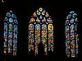 Saint-Germain Church,
Stained-glass windows of the choir -
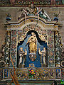 Saint-Germain Church,
Retable of the Rosary -
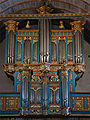 Saint-Germain Church,
The great organs


External links
[edit]Wikimedia Commons has media related to Pleyben.
- Tourism website [1]
- Base Mérimée: Search for heritage in the commune, Ministère français de la Culture. (in French)
- Mayors of Finistère Association (in French)
| International | |
|---|---|
| National | |
This Finistère geographical article is a stub. You can help Wikipedia by expanding it. |