Jump to content

Districts of Malawi

From Wikipedia, the free encyclopedia

This is an old revision of this page, as edited by Chadlupkes (talk | contribs) at 21:23, 30 January 2014 (→‎References: update URL). The present address (URL) is a permanent link to this revision, which may differ significantly from the current revision.

A clickable map of Malawi exhibiting its 28 districts.Chitipa DistrictKaronga DistrictLikoma DistrictLikoma DistrictMzimba DistrictNkhata Bay DistrictRumphi DistrictDedza DistrictDowa DistrictKasungu DistrictLilongwe DistrictMchinji DistrictNkhotakota DistrictNtcheu DistrictNtchisi DistrictSalima DistrictBalaka DistrictBlantyre DistrictChikwawa DistrictChiradzulu DistrictMachinga DistrictMangochi DistrictMulanje DistrictMwanza DistrictNsanje DistrictThyolo DistrictPhalombe DistrictZomba District
A clickable map of Malawi exhibiting its 28 districts.

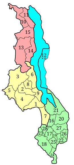
Malawi is divided into 28[1] districts within three regions. Each District is headed by a District Commissioner:[2]

Notes

  1. ^ Parliament of Malawi
  2. ^ http://training.fema.gov/EMIWeb/edu/Comparative%20EM%20Book%20-%20Chapter%20-%20Emergency%20Management%20In%20Malawi.doc
  3. ^ Neno is not listed on this map. The district was created from a division of the Mwanza district

See also

References

"Parliament of Malawi". Retrieved 2008-08-01.