
Decatur County, Iowa
Decatur County | |
|---|---|
 Location within the U.S. state of Iowa | |
 Iowa's location within the U.S. | |
| Coordinates: 40°44′29″N 93°46′51″W / 40.741388888889°N 93.780833333333°W | |
| Country | |
| State | |
| Founded | 1846 |
| Named for | Stephen Decatur, Jr. |
| Seat | Leon |
| Largest city | Lamoni |
| Area | |
| • Total | 533.32 sq mi (1,381.3 km2) |
| • Land | 531.80 sq mi (1,377.4 km2) |
| • Water | 1.52 sq mi (3.9 km2) 0.29% |
| Population (2010) | |
| • Total | 8,457 |
| • Density | 16/sq mi (6/km2) |
| Time zone | UTC−6 (Central) |
| • Summer (DST) | UTC−5 (CDT) |
| Congressional district | 2nd |
Decatur County is a county located in the U.S. state of Iowa. The population was 8,457 in the 2010 census, a decline from 8,689 in the 2000 census.[1] The county seat is Leon.Template:GR This county is named for Stephen Decatur, Jr., a hero in the War of 1812.[2]
Geography
According to the 2000 census, the county has a total area of 533.32 square miles (1,381.3 km2), of which 531.80 square miles (1,377.4 km2) (or 99.71%) is land and 1.52 square miles (3.9 km2) (or 0.29%) is water.[3]
Native vegetation based on NRCS soils information shows: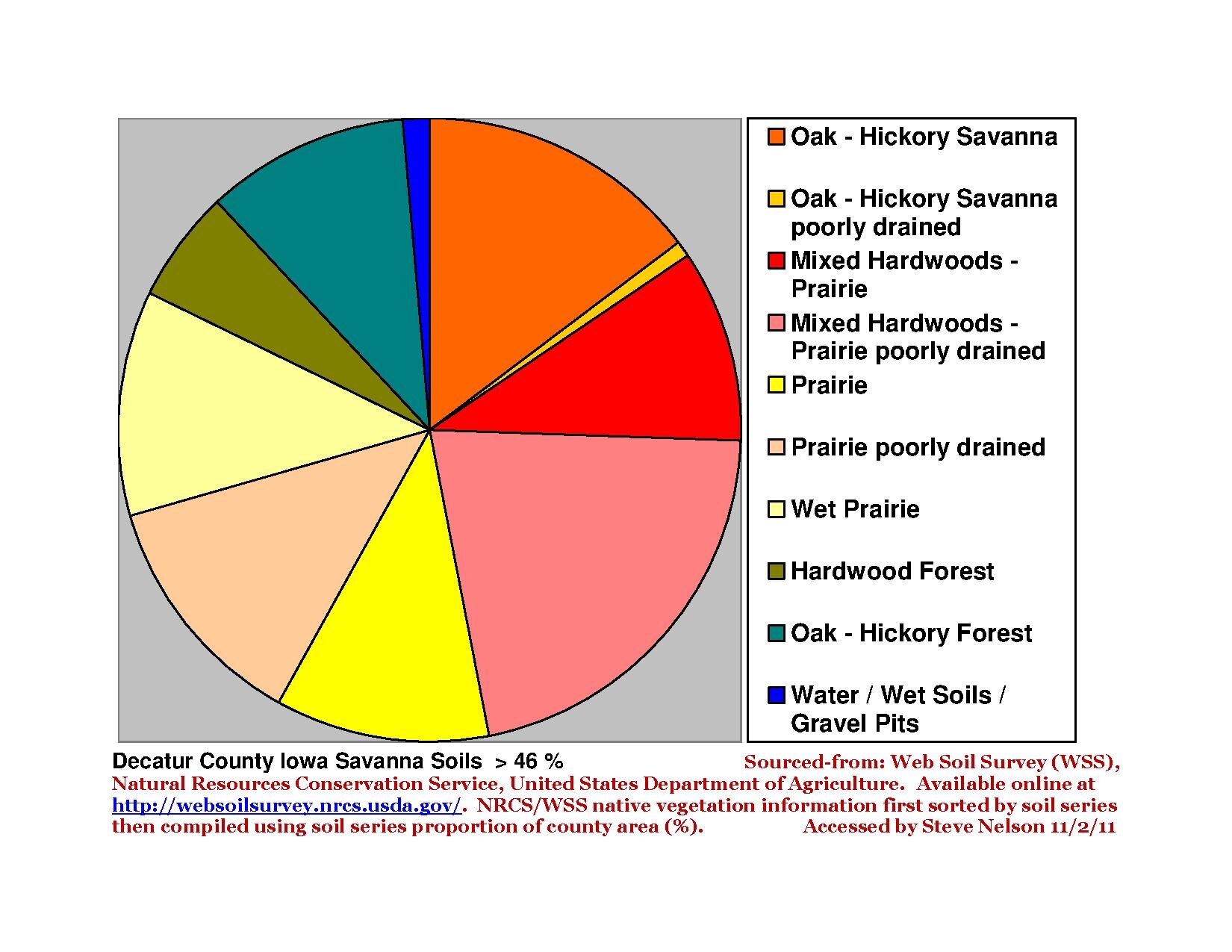 [4]
[4]
Major highways
Adjacent counties
- Clarke County (north)
- Wayne County (east)
- Mercer County, Missouri (southeast)
- Harrison County, Missouri (southwest)
- Ringgold County (west)
Demographics
| Census | Pop. | Note | %± |
|---|---|---|---|
| 1850 | 965 | — | |
| 1860 | 8,677 | 799.2% | |
| 1870 | 12,018 | 38.5% | |
| 1880 | 15,336 | 27.6% | |
| 1890 | 15,643 | 2.0% | |
| 1900 | 18,115 | 15.8% | |
| 1910 | 16,347 | −9.8% | |
| 1920 | 16,566 | 1.3% | |
| 1930 | 14,903 | −10.0% | |
| 1940 | 14,012 | −6.0% | |
| 1950 | 12,601 | −10.1% | |
| 1960 | 10,539 | −16.4% | |
| 1970 | 9,737 | −7.6% | |
| 1980 | 9,794 | 0.6% | |
| 1990 | 8,338 | −14.9% | |
| 2000 | 8,689 | 4.2% | |
| 2010 | 8,457 | −2.7% | |
| 2012 (est.) | 8,253 | −2.4% | |
2012 Estimate[6] | |||
2010 census
The 2010 census recorded a population of 8,457 in the county, with a population density of 15.897/sq mi (6.138/km2). There were 3,834 housing units, of which 3,223 were occupied.[1]
2000 census

At the 2000 census,Template:GR there were 8,689 people, 3,337 households and 2,149 families residing in the county. The population density was 16 per square mile (6/km²). There were 3,833 housing units at an average density of 7 per square mile (3/km²). The racial makeup of the county was 96.46% White, 0.98% Black or African American, 0.24% Native American, 0.63% Asian, 0.12% Pacific Islander, 0.46% from other races, and 1.12% from two or more races. 1.70% of the population were Hispanic or Latino of any race.
There were 3,337 households of which 28.00% had children under the age of 18 living with them, 54.30% were married couples living together, 7.20% had a female householder with no husband present, and 35.60% were non-families. 30.30% of all households were made up of individuals and 15.50% had someone living alone who was 65 years of age or older. The average household size was 2.37 and the average family size was 2.96.
23.00% of the population were under the age of 18, 16.30% from 18 to 24, 21.60% from 25 to 44, 21.50% from 45 to 64, and 17.70% who were 65 years of age or older. The median age was 36 years. For every 100 females there were 95.70 males. For every 100 females age 18 and over, there were 91.90 males.
The median household income was $27,343 and the median family income was $34,831. Males had a median income of $25,569 compared with $19,309 for females. The per capita income for the county was $14,209. About 10.90% of families and 15.50% of the population were below the poverty line, including 15.60% of those under age 18 and 13.70% of those age 65 or over.
Decatur County is considered to be the poorest in Iowa, reporting that almost 20% of its residents live in poverty.[7]
Localities
Cities

Townships
Decatur County is divided into these townships:
See also
- Decatur County Courthouse (Iowa)
- National Register of Historic Places listings in Decatur County, Iowa
References
- ^ a b "Population & Housing Occupancy Status 2010". United States Census Bureau American FactFinder. Retrieved May 8, 2011.
- ^ Gannett, Henry (1905). The Origin of Certain Place Names in the United States. Govt. Print. Off. p. 102.
- ^ "Census 2000 U.S. Gazetteer Files: Counties". United States Census. Retrieved 2011-02-13.
- ^ Nelson, Steven (2011). Savanna Soils of Minnesota. Minnesota: Self. ISBN 978-0-615-50320-2.
- ^ "U.S. Decennial Census". Census.gov. Retrieved August 3, 2013.
- ^ "Annual Estimates of the Resident Population: April 1, 2010 to July 1, 2012". Census.gov. Retrieved August 3, 2013.
- ^ Mike Kilen, "Headline: Who will win in Iowa's poorest county?", Des Moines Register, 6 June 2004 (subscription required)
External links
Places adjacent to Decatur County, Iowa | ||||||||||||||||
|---|---|---|---|---|---|---|---|---|---|---|---|---|---|---|---|---|
| ||||||||||||||||
Municipalities and communities of Decatur County, Iowa, United States | ||
|---|---|---|
| Cities |  | |
| Townships | ||
| Unincorporated communities | ||