
Rangamati
This article contains wording that promotes the subject in a subjective manner without imparting real information. (February 2010) |
Rangamati
Rangamatte (Chakma) | |
|---|---|
 | |
| Nickname: Lake City of Bangladesh | |
| Country | |
| Division | Chittagong Division |
| District | Rangamati District |
| Government | |
| • Pouroshava Mayor | Habibur Rahman |
| • Chakma Raja (Chakma Circle Chief) | Devasish Roy |
| Elevation | 49 ft (14 m) |
| people are mainly indigenous but their also live common people like bangali | |
| Time zone | UTC+6 (BST) |
| • Summer (DST) | BDST |
| Postal Code | 4500 |
| Area code | 0351 |

Rangamati (Chakma: 𑄢𑄋𑄟𑄖𑄳𑄡, is the administrative headquarters of Rangamati Hill District in the Chittagong Hill Tracts of Bangladesh.It is also a Capital city of Chittagong Hill Tracts. The town is located at 22°37'60N 92°12'0E and has an altitude of 14 metres (49 feet).[1]
It's a travel destination of Bangladesh which is known as "Lake City".The district is administered by an office named as District Administration,Rangamati
Rangamati Bangladesh http://www.rangamatitour.com
From Chittagong a 77 km road amidst green fields and winding hills leads to Rangamati; which is a wonderful repository of scenic splendours with flora and fauna of varied descriptions. The township is located on the western bank of the Kaptai lake. Rangamati is a favourite holiday destination because of its beautiful landscape, scenic beauty, lake, colourful indigenus groups (Chakma, Marma etc.), its flora and fauna, indigenous museum, hanging bridge, homespun textile products, ivory jewellery and the indigenous men and women who fashion them. For tourists, the attractions of Rangamati are numerous. Indigenous life, fishing, speed boat cruising, hiking, bathing or merely enjoying nature as it is.
1.rajban bihar pagoda 2.peda ting ting 3.tribal cultural museum 4.hanging bridge 5.shuvolong 6.kaptai national park 7.royal chakma palace 8.rangamati kaptai lake
Gallery
-
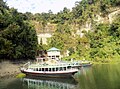
 Country boat at Kaptai Lake
 -
 Lower portion of the Shuvolong Fall
 -
 Shuvolong Choto Jhorna, a small sized water fall near the Shuvolong fall
 -
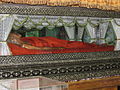 Mummified Body of the Top Mohanto at Rajbana Vihara
 -
 Rajbana Vihara, a renowned Buddhist Temple at Rangamati
 -
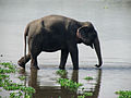 Wild Asian elephant, can be seen in the hilly forests of Rangamati
 -
 Kaptai Lake PEDA TING TING restaurant
 -
-
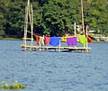
 Kaptai Lake Thami for sale
 -
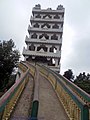 Seven Heaven, Rajbana Vihara
 -
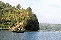
 Kaptai LakeView during afternoon
 -
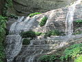
 Shuvolong waterfall in dry season
 -
 Kaptai LakeView during noon time
 -
 Life in Water
 -
 Speed boat racing Kaptai Lake
 -
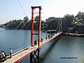 Hanging bridge Rangamati
 -
 This is the first & largest hanging bridge (jhulonta shetu in Bengali) of Bangladesh.


