Guanmiao District
Appearance
22°57′9.1″N 120°20′3.3″E / 22.952528°N 120.334250°E
Guanmiao
關廟區 | |
|---|---|
| Guanmiao District | |
 | |
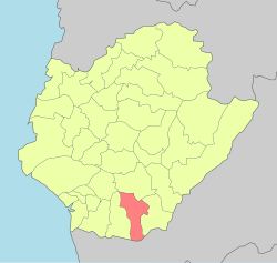
 Guanmiao District in Tainan City | |
| Location | Tainan, Taiwan |
| Area | |
| • Total | 54 km2 (21 sq mi) |
| Population (January 2023) | |
| • Total | 33,436 |
| • Density | 620/km2 (1,600/sq mi) |
| Website | guanmiao |
Guanmiao District (Chinese: 關廟區; pinyin: Guānmiào Qū; Wade–Giles: Kuan1-miao4 Ch'ü1; Pe̍h-ōe-jī: Koan-biō-khu) is a rural district in southeastern Tainan, Taiwan.[1]
History
After the handover of Taiwan from Japan to the Republic of China in 1945, Guanmiao was organized as a rural township of Tainan County. On 25 December 2010, Tainan County was merged with Tainan City and Guanmiao was upgraded to a district of the city.
Geography
- Area: 53.64 km2
- Population: 33,436 people (January 2023)
Administrative divisions
The district consists of Guanmiao, Shanxi, Xiangyang, Beishi, Xinpu, Xinguang, Wujia, Tungshi, Songjiao, Shenkeng, Budai, Beitou, Xiahu, Huayuan and Nanxiong Village.[2]
Tourist attractions

- Datan Lake Wanglai Park
- Fang Family Shrine
- Guanmiao Forest Park
- Guanmiao Shansi Temple
- Hills of Seven Constellations
- Sinfeng Church
- Thousand-Buddha Bodhi Temple
- Tiesian Bridge
- Yu Zen Retirement Center[1]
Transportation
Guanmiao Service Area and an interchange of the Formosa Freeway is located in here.
Notable natives
- Kuo Kuo-wen, Deputy Minister of Labor (2016–2017)
- Chien-Ming Wang, MLB Pitcher(2000–2016)
References
- ^ a b "Guanmiao Township". Archived from the original on 21 February 2014. Retrieved 8 February 2014.
- ^ "2018 Local Elections". Archived from the original on 5 December 2018. Retrieved 18 April 2019.
External links
Wikimedia Commons has media related to Guanmiao District, Tainan.
