
Panama City
Panama City
Ciudad de Panamá | |
|---|---|
| From top left: Punta Paitilla; Bellavista; Costa del Este; Downtown Panama Bay;Tocumen International Airport; Ancón Hill; Centenario Bridge; Bridge of the Americas; Panama Canal; Isla Flamenco Marina; and Amador. From top left: Punta Paitilla; Bellavista; Costa del Este; Downtown Panama Bay;Tocumen International Airport; Ancón Hill; Centenario Bridge; Bridge of the Americas; Panama Canal; Isla Flamenco Marina; and Amador. | |
| Country | Panama |
| Province | Panama |
| District | Distrito Central |
| Government | |
| • Mayor | Bosco Vallarino |
| Area | |
| • City | 275 km2 (106 sq mi) |
| • Metro | 2,560.8 km2 (988.7 sq mi) |
| Elevation | 576 m (1,890 ft) |
| Population (2000) | |
| • City | 813,097 |
| • Density | 2,750/km2 (129/sq mi) |
| • Metro | 1,206,792 |
| Website | http://www.municipio.gob.pa/ |
| HDI (2007) 0.937 – high | |
Panama City (Spanish: Ciudad de Panamá) is the capital and largest city of the Republic of Panama. It has a population of 813,097, with a total metro population of 1,206,792, and it is located at the Pacific entrance of the Panama Canal, at 8°58′N 79°32′W / 8.967°N 79.533°W. Panama City is the political and administrative center of the country.
With an average GDP per capita of $38,900, Panama has been for 8 years in the top 5 places for retirement in the world according to International Living Magazine. Panama City has a dense skyline of mostly highrise apartment buildings and condos, but office complexes and hotels as well. Panama City is also an important hub for international banking and commerce. It has an advanced communications service, Internet use is widespread; and Panama's Tocumen International Airport offers daily flights to international destinations.
Panama City was chosen to be the American Capital of Culture for the year 2003 (jointly, with Curitiba, Brazil).
History
The city was founded on August 15, 1519. Within years of its founding, the city became a launching point for the exploration and conquest of Peru and a transit point for gold and silver headed towards Spain. In 1671, the Welsh pirate Henry Morgan, with the help of a band of 1400 men, attacked and looted the city, which was subsequently destroyed by fire. The ruins of the old city still remain and are a popular tourist attraction known as Panamá la Vieja (Old Panama). It was rebuilt in 1673 in a new location approximately 5 miles (8.0 km) southwest of the original city. This location is now known as the Casco Viejo (Old Quarter) of the city.
Two years after the start of the California Gold Rush in 1848, the Panama Railroad Company was formed,[1] but the railroad did not begin operation until 1855.[2] Between 1848 and 1869, the year the first transcontinental railroad was completed in the United States, about 375,000 people crossed the isthmus from the Atlantic to the Pacific, and 225,000 in the opposite direction. That traffic greatly increased the prosperity of the city during that period.
The construction of the Panama Canal was of great benefit to the infrastructure and economy. Of particular note are the improvements in health and sanitation brought about by the American presence in the Canal Zone. These include the eradication of yellow fever and malaria and the introduction of a first-rate water supply system. However, most of the workers involved in the construction of the canal were brought in from the West Indies, which created unprecedented racial and social tensions in the city.
During World War II, construction of military bases and the presence of larger numbers of U.S. military and civilian personnel brought about unprecedented levels of prosperity to the city.[citation needed] Panamanians had limited access, or no access at all, to many areas in the Canal Zone neighboring the Panama metropolitan area. [citation needed] Some of these areas were military bases accessible only to United States personnel. Tensions arose between the people of Panama and the U.S. citizens living in the Panama Canal Zone. This erupted in the January 9, 1964 riots.

In the late 1970s through the 1980s Panama became an international banking center, bringing a lot of undesirable attention as an international money-laundering center. In 1989 after nearly a year of tension between the United States and Panama, President George H. W. Bush ordered the invasion of Panama to depose the previously U.S.-backed dictator of Panama, General Manuel Noriega. As a result of the action a portion of the El Chorrillo, a neighborhood which consisted mostly of old wood-framed buildings dating back to the 1900s, was destroyed by fire. Eventually, the U.S. helped finance the construction of large cinderblock apartment buildings to replace the destroyed structures. Panama City remains a major banking center, although with very visible controls against money laundering. Shipping is handled through port facilities in the area of Balboa operated by the Hutchison Whampoa Company of Hong Kong and through several ports on the Caribbean side of the isthmus. Balboa, which is located within the greater Panama metropolitan area, was formerly part of the Panama Canal Zone, and in fact the administration of the former Panama Canal Zone was headquartered there. The city of Balboa and the nation's currency, the Panamanian Balboa, are named after the Spanish conquistador and explorer Vasco Núñez de Balboa.
Geography and Climate
Panama City is located in the Pacific coast of Panama, east of the Panama Canal. Panama City experiences a Tropical Equatorial climate with a wet season that stretches from May to December, and a dry season from January to April. Annual temperatures range between 21 °C (70 °F) and 35 °C (95 °F).[3]
| Climate data for Panama City, Panama | |||||||||||||
|---|---|---|---|---|---|---|---|---|---|---|---|---|---|
| Month | Jan | Feb | Mar | Apr | May | Jun | Jul | Aug | Sep | Oct | Nov | Dec | Year |
| Source: Weather Underground [4] | |||||||||||||
Panama City as a tourism destination

The city has numerous tourist attractions including world-class hotels and restaurants. Particularly interesting for tourists are various sites located in the old quarter (also commonly referred to as "Casco Viejo", "Casco Antiguo" or "San Felipe"), including
- Las Bóvedas,[5] literally The Vaults, a waterfront promenade jutting out into the Pacific.
- The National Institute of Culture Building and across from it, the French Embassy;
- The Cathedral on Plaza de la Catedral
- Teatro Nacional, a recently renovated performance center, with outstanding natural acoustics; It provides an intimate performance environment and seating for about 800 guests.
- Museo del Canal Interoceánico (Interoceanic Canal Museum);
- Numerous restaurants located near the French embassy.
- Palacio de las Garzas (Heron's Palace), the official name of the presidential palace, named for the numerous herons that inhabit the building.
The area immediately east of the Pacific entrance of the canal—known as the Amador Causeway[6]-- is currently being developed as a major tourist center. Currently the Smithsonian Tropical Research Institute operates a station and a small museum open to the public at Culebra Point on the island of Naos. A new museum, The Bridge of Life Museum, is currently under construction on the causeway. The Bridge of Life Museum was designed by the American architect Frank Gehry famous for the Guggenheim Museum Bilbao and the Disney Concert Center in Los Angeles and it is scheduled to be completed this year.[7]
Panama as a World Heritage Site
| UNESCO World Heritage Site | |
|---|---|
 | |
| Criteria | Touristic, Cultural and Global: II, IV, VI |
| Inscription | 1997 (21st Session) |
| Extensions | 2003 |
Panama La Vieja (Old Panama) is the name used for the architectural vestiges of the Monumental Historic Complex of the first Spanish city founded on the Pacific coast of the Americas by Pedro Arias de Avila on 15 August 1519. This city was the starting point of the expeditions that conquered the Inca Empire in Peru (1532). It also was a stopover point of one of the most important trade routes in the history of he American continent leading to the famous fairs of Nombre de Dios and Portobelo where most of the gold and Silver that Spain took from the Americas passed through.[8]
The Committee decided to inscribe this property on the basis of cultural criteria (ii), (iv) and (vi), considering that Panamá was the first European settlement on the Pacific coast of the Americas, in 1519, and the Historic District preserves intact a street pattern, together with a substantial number of early domestic buildings, which are exceptional testimony to the nature of this early settlement.[9]
Casco Viejo or Casco Antiguo, Panama
Casco Antiguo was designated a World Heritage Site. After the first settlement was destroyed by diseases and the pirate attacks, the last and most remembered one by Henry Morgan, the city moved into a rocky peninsula that was both healthier and easier to defend. In 1673 they founded what today is called officially Casco Antiguo, but is also known as San Felipe, Catedral and more commonly, Casco Viejo.
Currently under a revitalization process, Casco Antiguo is a mix of different architectural styles, which reflects the cultural diversity of the country. Caribbean, Republican, Art Deco, French and Colonial mix in a site of less than 800 buildings. Most of Panama´s City´s main monuments are located in Casco Antiguo: The Salón Bolivar, the main Cathedral (Catedral Metropolitana), the National Theatre (founded in 1908), Las Bovedas Monument, La Iglesia de La Merced, La Iglesia San Felipe Neri, Iglesia San José with its distinctive Golden Altar, which was saved from Panama La Vieja and transported into the new city.
Resources: Ciudad City (www.ciudadcity.net) by Arq. Eduardo Tejeira Davis. This publication is from the United Nations Development Programme ( PNUD).
The only example of true urban revitalization in the Panama, Casco Antiguo is already the second touristic destination in Panama City, second only to the Panama Canal. Both government and private sectors are actively participating not only in the restoration of the architectural patrimony but also of the human patrimony, investing in cultural industries and local entrepreneurship.[10]
Demographics
The City Proper has around 813,097 inhabitants in the 23 Panama City boroughs.[11]
Nature in the City

Panama is located between the Pacific Ocean and many tropical rain forests. The Parque Natural Metropolitano (Metropolitan Nature Park), stretching from Panama along the Panama Canal, has several unique bird species and other animals such as tapir, puma, alligators, etc. At the Pacific entrance of the canal is the Centro de Exhibiciones Marinas (Marine Exhibitions Center), a research center for those interested in tropical marine life and ecology. Centro de Exhibiciones Marinas is managed by the Smithsonian Tropical Research Institute.
Tropical forests around Panama are vital for the functioning of the Panama Canal. These forests provide the canal with the watershed required for its operation (a rare example of a vast engineering project in the middle of the forest which actually helped preserve that very nature). Due to the importance of the Canal to the Panamanian economy, tropical forests around the canal have been kept in an almost pristine state. Along the western side of the Canal is the Parque Nacional Soberania (Sovereignty National Park) which includes Summit botanical gardens and a zoo. In this national park, the best known trail is the Pipeline Road, very popular among birdwatchers.[12]
Urban Problems

Due to lack of urban planning throughout several decades, Panama is now facing several urban problems. With the large number of condominiums and office buildings being built, population density is increasing far beyond what was previously expected.[13] Neighborhoods like El Cangrejo and El Carmen, originally designed for a density of 10,000 inhabitants per square kilometer (26,000/sq mi) are now reaching 35,000 inhabitants per square kilometer (91,000/sq mi).[14] The city's downtown streets are overcrowded with cars, creating traffic and air pollution problems.[15] In addition, Panama City's existing water supply piping system is not receiving enough maintenance and this is causing several water pollution related problems. Another important problem is the shape of the city: Panama has grown following the shape of a narrow strip along the coast as it expands to the northeast. This is mainly because Panama is limited in the south by the Pacific Ocean, in the north by the protected lands of the Metropolitan Park and other national parks of the Panama Canal Basin, and in the west with the Panama Canal itself. Subsequently Panama has expanded mostly eastwards, in an irregular funnel-like shape.
Economic overview

Panama has a total of more than 80 banks, more than 15 of them being national. The city also boasts several tourist attractions, and is a stopover for other nearby destinations in the country as well as a tourist destination in its own right. The city is also responsible for the production of about 55% of the country's GDP. This because most businesses and premises are located in the city and its metro area.[16] Nowadays tourism is the most important economic activity in terms of revenue generation. The hotel occupancy rate is the 2nd highest (84.7 percent) in the world after Perth, Australia and followed by Dubai (84.5 percent).
The communications systems are highly developed and are among Central America's most reliable. Internet use is widespread due to Panama's high income.
Developers and investors from around the world are showing massive attraction towards the Panama real estate market. This attraction is caused by the fact that the country’s canal is planned for expansion and many other such developments are likely to take place in the country that will lead it to reach an economically developed state of worth US$12 billion.[17]
Infrastructure

Panama currently has more than 110 high-rise projects being constructed, with 127 high-rise buildings already built.[18] It currently holds the 65th place in the world by highrise buildings count.[19]
The Centennial Bridge, that crosses the Panama Canal earned the American Segmental Bridge Institute prize of excellence together with 7 other bridges in the Americas.[20]
Panama City has full access to electric service, potable water, sewer lines, telephone, cable TV service, and internet service. Telecommunications are very advanced after the privatization of the national telecommunication company in the mid-1990s. Cell phone service is also very accessible. Panama City has for years boasted some of the cleanest, best-tasting water in the world. Tap water quality is excellent throughout the City metropolitan areas.

Healthcare
Panama counts 11 medical complexes. Around 45% of Panama physicians are located in Panama City.[21]
Panama offers good-quality medical care and modern hospitals in the metropolitan area, however, the more isolated the location, the harder it is to access these services. The hospitals offer first-rate medical care. Many Panamanian doctors are U.S. trained, and the standards at the top hospitals compare favorably to those in the United States.
Transportation
Panama's international airport, Tocumen International Airport has two runways and is located on the eastern outskirts of the city where it is easily accessible. There are direct flights between Tocumen and New York, Newark, Washington D.C., Los Angeles, Houston, Dallas, Orlando, Miami, Fort Lauderdale, Atlanta, Amsterdam, Madrid, and all major cities in the Caribbean area, Central America and South America. Panama City also has a regional airport Marcos A. Gelabert, located in an area once occupied by Albrook Air Force Base. Marcos A. Gelabert Airport is the main hub for regional flights within Panama and the Pearl Islands in the Pacific. Panama has an extensive and efficient, yet confusing to tourists, form of public transportation consisting of colorful painted buses colloquially known as diablo rojo. A diablo rojo is usually "customized" or painted with bright colors, usually depicting famous actors, politicians or singers. It is now popular all over the city (and also in neighboring towns) for bus drivers to personally customize the interior and exterior of their diablo rojo. There is also a bus terminal near the Marcos A. Gelabert airport which together with the airport serves as the main transport hub for the rest of the country. Panama City's only transportation problem includes frequent traffic jams due to the high levels of private transport ownership.
Sports
- Association Football
- Panama City is home to three professional teams in the country's top football league, ANAPROF:
- Panama City is also home to two professional teams in the country's second level league, Primera A (Segunda Division):
- Deportivo Italia
- Rio Abajo F.C.
Photographs of the city
-
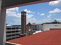 The belltower of the St. John Bosco Basilica.
 -
 In Casco Viejo.
 -
A Casco Viejo street paralleling the water, near to the Hospedaje Casco Viejo.
-
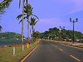 Causeway connecting Naos, Perico and Flamenco Islands to the mainland. A bicycle path parallels the roadway.
 -
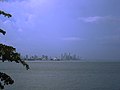 Panama City at dusk as seen from the Bay of Panama.
 -
 The entrance to the Panama Canal from the Pacific Ocean, the Bridge of the Americas at night.
 -
 Panama City seen from Isla Flamenco, an island linked to the city by Amador Causeway, a link made with rocks excavated from the Canal.
 -
French Plaza (Plaza de Francia) in Casco Viejo. In the image, a monument erected in the Plaza de Francia in honor of the workers and French engineers that participated in the construction of the Panama Canal.


References
- ^ The Panama Railroad from Trainweb
- ^ [http://cdl.library.cornell.edu/cgi-bin/moa/pageviewer?frames=1&coll=moa&view=50&root=%2Fmoa%2Fharp%2Fharp0010%2F&tif=00553.TIF&cite=http%3A%2F%2Fcdl.library.cornell.edu%2Fcgi-bin%2Fmoa%2Fmoa-cgi%3Fnotisid%3DABK4014-0010-69 Harper's New Monthly Magazine March 1856 , Volume 11, Issue 58, p.543]
- ^ "Panama City Hall"
- ^ "Panama City". Weather Underground. Retrieved 2009-08-01.
- ^ Las Bovedas: Casco Viejo Bar
- ^ Jogging in Paradise...but where is everbody? The Panama Report
- ^ Panama:Bridge of Life|Biodiversity Museum
- ^ "World Heritage Site"
- ^ "UNESCO Official Site"
- ^ http://www.arcoproperties.com/blogs/main/PermaLink,guid,fdc48ceb-4b4e-427c-af4c-e3131de40e66.aspx
- ^ “Panama City Hall (Spanish”
- ^ Canopy Tower, a famous birdwatchers hotel
- ^ "burica wordpress"
- ^ “La Prensa Newspaper”
- ^ “La Prensa Newspaper”
- ^ Municipio de Panamá
- ^ Panama Real Estate News
- ^ “Skyscraper page Panama City”
- ^ “Skyscraper page Cities List”
- ^ “La Prensa Newspaper”
- ^ “Panama City Hall – Healthcare”
- Mellander, Gustavo A.; Nelly Maldonado Mellander (1999). Charles Edward Magoon: The Panama Years. Río Piedras, Puerto Rico: Editorial Plaza Mayor. ISBN 1563281554. OCLC 42970390.
- Mellander, Gustavo A. (1971). The United States in Panamanian Politics: The Intriguing Formative Years. Danville, Ill.: Interstate Publishers. OCLC 138568.