
Opportunity (rover): Difference between revisions
| Line 408: | Line 408: | ||
====Leaving Cape York==== |
====Leaving Cape York==== |
||
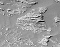
[[Image:PIA17074-MarsOpportunityRover-EsperanceRock-20130223-fig1.jpg|thumb| |
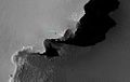
[[Image:PIA17074-MarsOpportunityRover-EsperanceRock-20130223-fig1.jpg|thumb||150px|"[[List of rocks on Mars#Opportunity|Esperance]]" [[Rock (geology)|rock]] on Mars – viewed by the ''Opportunity'' Rover (February 23, 2013).]] |
||
Opportunity began the year at the edge of Endeavour Crater's Cape York,<ref name=sol3174/> and the total distance travelled since landing on Mars was {{convert |35|km |mi |abbr=on}}.<ref name=sol3174/><ref>[http://www.marsdaily.com/reports/Opportunity_Scores_Another_Dust_Cleaning_Event_At_Vermillion_999.html Mars Daily Staff - Opportunity Scores Another Dust Cleaning Event At Vermillion]</ref> After completing work at Matijevic Hill the Opportunity rover headed south to the rim of Endeavour Crater. Next, the rover headed south across a gap in the rim to a place the researchers called Botany Bay, then up onto the next rim segment to the south. There are two hills to the south of it, one called Solander Point and farther south is Cape Tribulation.<ref name="SFN-20130125">{{cite web |last=Harwood |first=William |title=Opportunity rover moves into 10th year of Mars operations |url=http://www.spaceflightnow.com/news/n1301/25opportunity/ |date=January 25, 2013 |publisher=Space Flight Now |accessdate=February 18, 2013 }}</ref> The current aim is for Opportunity to reach Solander Point before winter reaches the Martian southern hemisphere as the area has ground tilted to the north allowing the rover to stay active during the winter months. In addition Solander Point has a large geological stack for Opportunity to explore.<ref>[http://www.nasa.gov/mission_pages/mer/news/mer20130607.html [[NASA]] - Mars Rover Opportunity Trekking Toward More Layers]</ref> |
Opportunity began the year at the edge of Endeavour Crater's Cape York,<ref name=sol3174/> and the total distance travelled since landing on Mars was {{convert |35|km |mi |abbr=on}}.<ref name=sol3174/><ref>[http://www.marsdaily.com/reports/Opportunity_Scores_Another_Dust_Cleaning_Event_At_Vermillion_999.html Mars Daily Staff - Opportunity Scores Another Dust Cleaning Event At Vermillion]</ref> After completing work at Matijevic Hill the Opportunity rover headed south to the rim of Endeavour Crater. Next, the rover headed south across a gap in the rim to a place the researchers called Botany Bay, then up onto the next rim segment to the south. There are two hills to the south of it, one called Solander Point and farther south is Cape Tribulation.<ref name="SFN-20130125">{{cite web |last=Harwood |first=William |title=Opportunity rover moves into 10th year of Mars operations |url=http://www.spaceflightnow.com/news/n1301/25opportunity/ |date=January 25, 2013 |publisher=Space Flight Now |accessdate=February 18, 2013 }}</ref> The current aim is for Opportunity to reach Solander Point before winter reaches the Martian southern hemisphere as the area has ground tilted to the north allowing the rover to stay active during the winter months. In addition Solander Point has a large geological stack for Opportunity to explore.<ref>[http://www.nasa.gov/mission_pages/mer/news/mer20130607.html [[NASA]] - Mars Rover Opportunity Trekking Toward More Layers]</ref> |
||
In April 2013, the rover passed through a three-week long solar conjunction, when communication with Earth was blocked because of the Sun.<ref name=nasa3291>[http://marsrover.nasa.gov/mission/status_opportunityAll.html#sol3291 NASA - Sol 3291]</ref> The rover arm was positioned on a rock during that time so the APXS could collect data.<ref name=nasa3291/> |
In April 2013, the rover passed through a three-week long solar conjunction, when communication with Earth was blocked because of the Sun.<ref name=nasa3291>[http://marsrover.nasa.gov/mission/status_opportunityAll.html#sol3291 NASA - Sol 3291]</ref> The rover arm was positioned on a rock during that time so the APXS could collect data.<ref name=nasa3291/> |
||
Revision as of 17:33, 25 March 2014
 | |
| Mission type | Mars rover |
|---|---|
| Operator | NASA |
| COSPAR ID | 2003-032A |
| SATCAT no. | 27849 |
| Website | JPL's Mars Exploration Rover |
| Mission duration | Planned: 90 sols (92.5 days) Current: 7522 days since landing Currently: 7321 sols |
| Spacecraft properties | |
| Spacecraft type | Mars Exploration Rover |
| Dry mass | 185 kilograms (408 lb) (Rover only) |
| Start of mission | |
| Launch date | July 7, 2003[1][2] |
| Rocket | Delta II 7925H-9.5[2][3][4] |
| Launch site | Cape Canaveral SLC-17B |
| Contractor | Boeing |
| Orbital parameters | |
| Reference system | Heliocentric (transfer) |
| Mars rover | |
| Spacecraft component | Rover |
| Landing date | January 25, 2004,[1] 05:05 UTC SCET MSD 46236 14:35 AMT |
| File:Nasa mer daffy.jpg The launch patch for Opportunity, featuring Duck Dodgers (Daffy Duck) | |

Opportunity, MER-B (Mars Exploration Rover – B), is a robotic rover active on the planet Mars since 2004.[1] Launched on July 7, 2003, Opportunity landed on Mars' Meridiani Planum on January 25, 2004 at 05:05 Ground UTC (about 13:15 Mars local time), three weeks after its twin Spirit (MER-A), also part of NASA's Mars Exploration Rover Mission, touched down on the other side of the planet.[5] While Spirit became immobile in 2009 and ceased communications in 2010, Opportunity remains active as of 2014, having already exceeded its planned 90 sol (Martian days) duration of activity by 20 years, 125 days (in Earth time). Opportunity has continued to move, gather scientific observations, and report back to Earth for over 40 times its designed lifespan.
Mission highlights include the initial 90 sol mission, finding extramartian meteorites such as Heat Shield Rock (Meridiani Planum meteorite), and over two years studying Victoria crater. It survived dust-storms and reached Endeavour crater in 2011, which has been described as a "second landing site".[6]
The Jet Propulsion Laboratory (JPL), a division of the California Institute of Technology in Pasadena, California, manages the Mars Exploration Rover project for NASA's Science Mission Directorate in Washington, D.C..
Objectives

The scientific objectives of the Mars Exploration Rover mission are to:[7]
- Search for and characterize a variety of rocks and soils that hold clues to past water activity. In particular, samples sought will include those that have minerals deposited by water-related processes such as precipitation, evaporation, sedimentary cementation or hydrothermal activity.
- Determine the distribution and composition of minerals, rocks, and soils surrounding the landing sites.
- Determine what geologic processes have shaped the local terrain and influenced the chemistry. Such processes could include water or wind erosion, sedimentation, hydrothermal mechanisms, volcanism, and cratering.
- Perform calibration and validation of surface observations made by Mars Reconnaissance Orbiter instruments. This will help determine the accuracy and effectiveness of various instruments that survey Martian geology from orbit.
- Search for iron-containing minerals, identify and quantify relative amounts of specific mineral types that contain water or were formed in water, such as iron-bearing carbonates.
- Characterize the mineralogy and textures of rocks and soils and determine the processes that created them.
- Search for geological clues to the environmental conditions that existed when liquid water was present.
- Assess whether those environments were conducive to life.
During the next two decades, NASA will continue to conduct missions to address whether life ever arose on Mars. The search begins with determining whether the Martian environment was ever suitable for life. Life, as we understand it, requires water, so the history of water on Mars is critical to finding out if the Martian environment was ever conducive to life. Although the Mars Exploration Rovers do not have the ability to detect life directly, they are offering very important information on the habitability of the environment in the planet's history.
Design and construction
Opportunity (along with its twin, Spirit) is a six-wheeled, solar-powered robot standing 1.5 meters (4.9 ft) high, 2.3 meters (7.5 ft) wide, and 1.6 meters (5.2 ft) long and weighing 180 kilograms (400 lb). Six wheels on a rocker-bogie system enable mobility. Each wheel has its own motor, the vehicle is steered at front and rear and is designed to operate safely at tilts of up to 30 degrees. Maximum speed is 5 centimetres per second (2.0 in/s) although average speed is about a fifth of this (0.89 centimetres per second (0.35 in/s)). Both Spirit and Opportunity have pieces of the fallen World Trade Center's metal on them that were "turned into shields to protect cables on the drilling mechanisms".[8][9]
Solar arrays generate about 140 watts for up to four hours per Martian day (sol) while rechargeable lithium ion batteries store energy for use at night. Opportunity's onboard computer uses a 20 MHz RAD6000 CPU with 128 MB of DRAM, 3 MB of EEPROM, and 256 MB of flash memory. The rover's operating temperature ranges from −40 to +40 °C (−40 to 104 °F) and radioisotope heaters provide a base level of heating, assisted by electrical heaters when necessary.[10] A gold film and a layer of silica aerogel provide insulation.
Communications depends on an omnidirectional low-gain antenna communicating at a low data rate and a steerable high-gain antenna, both in direct contact with Earth. A low gain antenna is also used to relay data to spacecraft orbiting Mars.
Fixed science/engineering instruments include:
- Panoramic Camera (Pancam) – examines the texture, color, mineralogy, and structure of the local terrain.
- Navigation Camera (Navcam) – monochrome with a higher field of view but lower resolution, for navigation and driving.
- Miniature Thermal Emission Spectrometer (Mini-TES) – identifies promising rocks and soils for closer examination, and determines the processes that formed them.
- Hazcams, two B&W cameras with 120 degree field of view, that provide additional data about the rover's surroundings.
The rover arm holds the following instruments:
- Mössbauer spectrometer (MB) MIMOS II – used for close-up investigations of the mineralogy of iron-bearing rocks and soils.
- Alpha particle X-ray spectrometer (APXS) – close-up analysis of the abundances of elements that make up rocks and soils.
- Magnets – for collecting magnetic dust particles
- Microscopic Imager (MI) – obtains close-up, high-resolution images of rocks and soils.
- Rock Abrasion Tool (RAT) – exposes fresh material for examination by instruments on board.
The cameras produce 1024-pixel by 1024-pixel images, the data is compressed with ICER, stored, and transmitted later.
The rover's name was chosen through a NASA sponsored student essay competition.
Mission overview


The primary surface mission for Opportunity was planned to last 90 sols. The mission has received several extensions and has been operating for 7522 days since landing. An archive of weekly updates on the rover's status can be found at the Opportunity Update Archive.[11]
From its initial landing, by chance, into an impact crater amidst an otherwise generally flat plain, Opportunity has successfully investigated soil and rock samples and taken panoramic photos of its landing site. Its sampling allowed NASA scientists to make hypotheses concerning the presence of hematite and past presence of water on the surface of Mars. Following this, it was directed to travel across the surface of Mars to investigate another crater site, Endurance crater, which it investigated from June – December 2004. Subsequently, Opportunity examined the impact site of its own heat shield and discovered an intact meteorite, now known as Heat Shield Rock, on the surface of Mars.
From late April 2005 to early June of that year, Opportunity was perilously lodged in a sand dune, with several wheels buried in the sand. Over a six-week period Earth-based physical simulations were performed to decide how best to extract the rover from its position without risking a permanent immobilization of the valuable vehicle. Successful maneuvering a few centimeters at a time eventually freed the rover, which resumed its travels.
Opportunity was directed to proceed in a southerly direction to Erebus crater, a large, shallow, partially buried crater and a stopover on the way south towards Victoria crater, between October 2005 and March 2006. It experienced some mechanical problems with its robotic arm.
In late September 2006, Opportunity reached Victoria crater and explored along the rim in a clockwise direction. In June 2007 it returned to Duck Bay, its original arrival point; in September 2007 it entered the crater to begin a detailed study. In August 2008, Opportunity left Victoria crater for Endeavour crater, which it reached on August 9, 2011.[12] Here at the rim of the Endeavour crater the rover moved around a geographic feature named Cape York. The Mars Reconnaissance Orbiter had detected Phyllosilicates there, and the rover analyzed the rocks with its instruments to check this sighting on the ground. This structure was analyzed in depth until summer 2013. At May 2013 the rover was heading south to a hill named Solander Point.
Opportunity's total odometry as of November 5, 2013 (sol 3478) is 38.53 km (23.94 mi).[13]
Mission timeline
2004
Landing site: "Eagle" crater


Opportunity landed in Meridiani Planum at 1°57′S 354°28′E / 1.95°S 354.47°E, about 25 kilometers (16 mi) downrange (east) of its intended target on January 25, 2004 at 05:05.[14] Although Meridiani is a flat plain, without the rock fields seen at previous Mars landing sites, Opportunity rolled into an impact crater 22 meters in diameter, with the rim of the crater approximately 10 meters (33 ft) from the rover.[14] NASA Scientists were so excited about landing in a crater that they called the landing a "hole in one"; however, they were not aiming for the crater (and did not know it existed). Later, the crater was named Eagle crater and the landing site designated "Challenger Memorial Station".[15] This was the darkest landing site ever visited by a spacecraft on Mars. It would be two weeks before Opportunity was able to get a better look at its surroundings.
Scientists were intrigued by the abundance of rock outcrops dispersed throughout the crater, as well as the crater's soil, which appeared to be a mixture of coarse gray grains and fine reddish grains. This sweeping look at the unusual rock outcropping near Opportunity was captured by the rover's panoramic camera. Scientists believe the seemingly layered rocks are either volcanic ash deposits or sediments laid down by wind or water. It was given the name Opportunity Ledge.
Geologists said that the layers—some no thicker than a finger—indicate the rocks likely originated either from sediments carried by water or wind, or from falling volcanic ash. "We should be able to distinguish between those two hypotheses", said Dr. Andrew Knoll of Harvard University, Cambridge, a member of the science team for Opportunity and its twin, Spirit. If the rocks are sedimentary, water is a more likely source than wind, he said.[16]
These layered rocks measure only 10 centimeters (3.9 in) tall and are thought to be either volcanic ash deposits or sediments carried by water or wind. The layers are very thin measuring just a few millimeters thick in some cases.
"Opportunity Ledge" outcroppings

On Sol 15, Opportunity took a close up of the rock "Stone Mountain" in the outcrop area of the crater, raising speculation that the rock consisted of very fine grain or dust, in contrast to Earth sandstone, which is compacted sand with rather large grains. The weathering agent eroding away layers of this rock seemed to be visible as dark spots.[17]
A picture received on February 10 (taken on Sol 16) showed that the thin layers in the bedrock converge and diverge at low angles, suggesting that some "moving current" such as volcanic flow, wind, or water formed these rocks. The discovery of these layers was significant for scientists who had planned this mission to test the "water hypothesis" rigorously.
El Capitan outcropping

On February 19 the survey of "Opportunity Ledge" was declared successful. A specific target in the outcrop (dubbed "El Capitan"), whose upper and lower portions appeared to differ in layering and weathering characteristics, was selected for further investigation. El Capitan, about 10 centimeters (3.9 in) high, was named after a mountain in Texas.[18] Opportunity reached "El Capitan" on Sol 27, and took a first picture of the rocks with its panoramic camera.
On Sol 30, Opportunity used its Rock Abrasion Tool (RAT) for the first time to investigate the rocks around El Capitan. The image on the right-hand side shows a close up view taken after the drilling and cleaning process was complete. Due to chance, two spherules were also cut partially, and seem to show scratches and other marks made by the diamond-crusted grind tool. The black areas are artifacts of the imaging process, when parts of the picture are missing.
During a press conference on 36 March 2, 2004, mission scientists discussed their conclusions about the bedrock, and the evidence for the presence of liquid water during their formation. They presented the following reasoning to explain the small, elongated voids in the rock visible on the surface and after grinding into it (see last two images below).[19]
These voids are consistent with features known to geologists as "vugs". These are formed when crystals form inside a rock matrix and are later removed through erosive processes, leaving behind voids. Some of the features in this picture are "disk-like", which is consistent with certain types of crystals, notably sulfate minerals.
Additionally, mission members presented first data from the MIMOS II Mössbauer spectrometer taken at the bedrock site. The iron spectrum obtained from the rock El Capitan shows strong evidence for the mineral jarosite. This mineral contains hydroxide ions, which indicates the presence of water when the minerals were formed. Mini-TES data from the same rock showed that it consists of a considerable amount of sulfates.
-
 Close up of a rock outcrop.
 -
 Thin rock layers, not all parallel to each other.
 -
 Section of hole created by RAT.
 -
 Voids or "vugs" inside the rock.


Analyzing soil through digging a trench

In order to analyze the soil inside the crater it was decided to try to dig a trench with the wheels. The rover alternately pushed soil forward and backward out of the trench with its right front wheel while other wheels held the rover in place. The rover turned slightly between bouts of digging to widen the hole. The process lasted 22 minutes. The resulting trench — the first dug by either Mars Exploration Rover — is about 50 centimeters (20 in) long and 10 centimeters (3.9 in) deep.[20] Two features that caught scientists' attention were the clotty texture of soil in the upper wall of the trench and the brightness of soil on the trench floor.
By inspecting the sides and floor of a hole it dug, Opportunity found some things it did not see beforehand, including round pebbles that are shiny and soil so fine-grained that the rover's microscope could not make out individual particles.
What's underneath is different from what is at the immediate surface.[21] The soils consist of fine-grained basaltic sand and a surface lag of hematite-rich spherules, spherule fragments, and other granules. Underlying the thin soil layer, are flat-lying sedimentary rocks. These rocks are finely laminated, are rich in sulfur, and contain abundant sulfate salts.[22]
Endurance crater

On sol 84 April 20, 2004, the rover reached Endurance crater, which was known to have many layers of rocks.[23] In May the rover circumnavigated the crater, and made observations with Mini-TES and the panoramic camera. The rock "Lion Stone" was investigated on Sol 107[24] and found to be similar in composition to the layers found in Eagle crater.
On sol 127 June 4, 2004 mission members announced their intention to drive Opportunity into Endurance, even if it should turn out to be impossible to get back out, targeting the various rock layers that were identified in the pictures from the crater rim. "This is a crucial and careful decision for the Mars Exploration Rovers' extended mission", said Dr. Edward Weiler, NASA's associate administrator for space science. Steve Squyres, principal investigator from Cornell University said: "Answering the question of what came before the evaporites is the most significant scientific issue we can address with Opportunity at this time."[25]
A first drive into the crater was executed on sol 131 June 8, and Opportunity backed out again the same day.[26] It was found that the angle of the surface was well inside the safety margin (about 18 degrees), and the full excursion toward the rock layer of interest was started. During Sols 134 (June 12), 135, and 137 the rover drove deeper and deeper into the crater. Although some wheel slip was observed, driving was discovered to be possible even at slope angles up to 30 degrees.
Wispy clouds, similar to Earth's cirrus clouds, were spotted.
Opportunity spent roughly 180 sols inside the crater, before backing out of it again in mid December 2004, on Sol 315.[27] Scientific results of the sedimentary geology of the crater were published in the journal Earth and Planetary Science Letters[28]

2005
Heat Shield Rock and stuck in sand
After exiting Endurance crater, in January 2005 Opportunity went to examine its own discarded heat shield. While in the vicinity of the heat shield, on Sol 345 it happened to come upon an object that was immediately suspected and soon confirmed to be a meteorite. The meteorite was promptly named Heat Shield Rock,[29] and is the first meteorite identified on another planet (although the Bench Crater and Hadley Rille meteorites were found earlier on the Moon).
After about 25 sols of observations Opportunity headed south for a crater named Argo, nearly 300 meters (980 ft) from the heat shield.[30]
The rover was commanded to dig another trench on the vast plains of Meridiani Planum, on Sol 366, and observations continued until Sol 373 (February 10, 2005). The rover then passed the craters "Alvin" and "Jason", and by Sol 387, approached a "crater triplet" on its way to Vostok Crater. Along the way, Opportunity set a distance record for one-day travel by either rover: 177.5 meters (582 ft), on sol 381 February 19, 2005. On Sol 387 (February 26, 2005), the rover approached one of the three craters, dubbed Naturaliste. A rock target named "Normandy" was chosen for investigation on Sol 392, and Opportunity remained there until Sol 395.
Opportunity reached Vostok Crater on Sol 399, finding it mostly filled with sand and lined by outcrops. It was then ordered south into what has been called "etched terrain", to search for more bedrock.
On March 20, 2005 (Sol 410) Opportunity set a new Martian record for the longest single day drive when it drove 220 meters (720 ft).[31][32][33]
By Sol 415, Opportunity stopped by some soil ripples to investigate the differences between soil in the trough of a ripple and its crest. Various soil targets included "Mobarak" in the trough, named in honor of Persian New Year, and "Norooz" and "Mayberooz" on the crest. By Sol 421, the rover left the ripple for "Viking" crater.
Between April 26, 2005 (Sol 446) and June 4, 2005 (Sol 484) Opportunity was stuck in a Martian sand dune. The problem began on sol 445 (April 26, 2005) when Opportunity inadvertently dug itself into a sand dune: Mission scientists reported that images indicated all four corner wheels were dug in by more than a wheel radius, just as the rover attempted to climb over a dune about 30 centimeters (12 in) tall. The sand dune was designated "Purgatory Dune" by mission planners.
The rover's condition was simulated on Earth prior to any attempt to move, out of concern that the rover might become permanently immobilized. After various simulations intended to mimic the properties and behavior of Martian sand were completed, the rover executed its first wheel movements on sol 461 (May 13, 2005), intentionally advancing only a few centimeters, after which mission members evaluated the results.
During Sol 465 and 466 more drive commands were executed, and with each trial the rover moved another couple of centimeters. At the end of each movement, panoramic images were acquired to investigate the atmosphere and the surrounding dune field. The sand dune escape maneuver was successfully completed on sol 483 (June 4, 2005), and all six wheels of Opportunity were on firmer ground. After studying "Purgatory" from Sol 498 to Sol 510, Opportunity proceeded southward toward "Erebus crater".
-
 Heat Shield Rock was the first meteorite ever identified on another planet.
 -
 Heat shield, with Heat Shield Rock just above and to the left in the background.
 -
 Dug in back wheels on Sol 468.


Erebus crater
Opportunity studied Erebus crater, a large, shallow, partially buried crater and a stopover on the way south toward Victoria crater, between October 2005 and March 2006.
New programming to measure the percentage of slip in the wheels was successful in preventing the rover from getting stuck again. Another "Purgatory"-like incident was averted on Sol 603, when onboard slip check software stopped a drive after slip reached 44.5%.[34] It proceeded over many ripples and 'half-pipes', taking photographs after each sol's journey.
On Sol 631 (November 3, 2005) Opportunity woke up in the midst of a mild dust storm that lasted three days. The rover was able to drive in self-protective auto-mode during the storm, but it could not take any post-drive images. Less than three weeks later, another cleaning event cleared the dust off of the solar array so as to produce around 720 watt-hours (80% of max). On Sol 658 (December 1, 2005), it was discovered the motor used to stow the robotic arm for travel was stalling. This problem took nearly two weeks to fix. Initially the arm was stowed only for travel, and was extended at night to prevent the arm from getting stuck. However further stalling convinced engineers to leave the arm extended at all times to avoid the arm becoming stuck in the stowed position and becoming unusable.
Opportunity observed numerous outcroppings around Erebus crater.
It also collaborated with ESA's Mars Express by using the miniature thermal emission spectrometer and panoramic camera (Pancam), and took images of a transit across the Sun by Phobos. On Sol 766 (March 22, 2006), Opportunity began the journey to its next destination, Victoria crater, which it would reach in September 2006 (Sol 951).[35] It would stay at Victoria crater until August 2008 (Sol 1630–1634).[36]

Shoulder troubles
The "shoulder" joint of Opportunity's arm has had troubles since Sol 2 (January 25, 2004), the rover's second day on Mars. Engineers discovered that the heater on the shoulder azimuth joint, which controls side-to-side motion of the robotic arm, was stuck in the "on" position. Closer investigation revealed that the on-off switch had probably failed during assembly, test, and launch operations on Earth. Fortunately for Opportunity, the rover was equipped with a built-in safety mechanism called a "T-stat box" (thermostatic switch) that provided protection against overheating. When the shoulder azimuth joint, also known as Joint 1, got too hot, the T-stat switch automatically opened and temporarily disabled the heater. When the joint got cold again, the T-stat closed. As a result, the heater stayed on all night but not all day.

The safety mechanism worked until Opportunity approached the first winter on Mars. As the Sun began to retreat lower in the sky and solar power levels dropped, it became clear that Opportunity would not be able to keep the batteries charged with a heater draining power all night long. On Sol 121 (May 28, 2004), rover operators began using a procedure known as "deep sleep," during which Opportunity disconnected the batteries at night. Deep sleep prevented the stuck heater (and everything else on the rover except the clock and the battery heaters) from drawing power. When the Sun came up the next morning and sunlight began hitting the solar arrays, the batteries automatically reconnected, the robotic arm became operational, the shoulder joint warmed up, and the thermostatic switch opened, disabling the heater. As a result, the shoulder joint was extremely hot during the day and extremely cold at night. Such huge temperature swings, which tend to make electric motors wear out faster, were taking place every sol.
This strategy worked for Opportunity until Sol 654 (November 25, 2005), when the Joint-1 azimuth motor stalled because of increased electrical resistance. Rover operators responded by delivering higher-than-normal current to the motor. This approach also worked, though Joint 1 continued to stall periodically. Typically, the rover's handlers simply tried again the next sol and the joint worked. They determined that the Joint-1 motor stalls were most likely due to damage caused by the extreme temperature cycles the joint experienced during deep sleep. As a precaution, they started keeping the robotic arm out in front of the rover overnight, rather than stowing it underneath the rover deck, where it would be virtually unusable in the event of a Joint-1 motor failure. They stowed the arm only while driving and unstowed it immediately at the end of each drive.
2006
Journey to Victoria crater
On March 22, 2006 (Sol 760), Opportunity left Erebus crater and began the journey to Victoria crater, which it reached in September 2006 (Sol 951[35]). It would stay at Victoria crater until August 2008 (Sol 1630–1634).[36]
Arrival at Victoria crater
Victoria crater is a massive impact crater approximately 7 kilometers (4.3 mi) from the original landing site. Victoria's diameter is six times larger than Endurance crater. Scientists believed that rock outcrops along the walls of Victoria would yield more information about the geologic history of Mars, if the rover survived long enough to investigate them.
On Sol 949 (September 26, 2006) Opportunity reached the rim of Victoria Crater[37] and transmitted the first substantial views of Victoria, including the dune field at the bottom of the crater. The Mars Reconnaissance Orbiter photographed Opportunity at the rim of the crater.[38]

2007
Moving around Victoria's rim
On January 4, 2007, both rovers received new flight software for their computers. The update was received just in time for the third anniversary of their landing. The new systems let the rovers decide whether to transmit an image, and whether to extend their arms to examine rocks, which would save much time for scientists, as they would not have to sift through hundreds of images to find the one they want, or examine the surroundings to decide to extend the arms and examine the rocks.[39]
The APXS instrument was now for the first time used to determine the amount of the noble gas argon in the atmosphere of Mars. The same measurements were done on the other side of the planet by its rover twin Spirit. The purpose of this experiment was to determine the atmospheric mixing processes and track their changes with time.[40]
In January the rover drove along the north side of the crater rim and imaged the cliffs from different view points. While driving another meteorite was found: Santa Caterina.[41] In March the Valley without peril was reached. This point had thought to be a possible entry point into the crater. But it turned out that this point had a too steep slope to drive carefully downside. After two additional cliffs where inspected it was decided to drive the whole way back to the point, where Opportunity arrived at Victoria crater. On June 15, 2007 the rover arrived at Duck Bay and prepared for entering the crater.
A series of cleaning events beginning on Sol 1149 (April 20, 2007) allowed Opportunity's solar energy production to rise to above 800 watt-hours per Sol. By Sol 1163 (May 4, 2007) the solar array current was peaking above 4.0 amperes, values not seen since Sol 16 (February 10, 2004).[42] However, the advent of extensive dust storms on Mars starting in mid-2007 (in-line with Mars' six Earth-year global dust storm cycle), dropped energy production levels to 280 watt-hours per day.[43]
Dust storms

Toward the end of June 2007, a series of dust storms began clouding the Martian atmosphere with dust. The storms intensified and by July 20, both Opportunity and Spirit were facing the real possibility of system failure due to lack of power. NASA released a statement to the press that said (in part) "We're rooting for our rovers to survive these storms, but they were never designed for conditions this intense".[44] The key problem caused by the dust storm was a dramatic reduction in solar power. There was so much dust in the atmosphere that it blocked 99 percent of direct sunlight to the rover. The Spirit rover, on the other side of the planet was getting slightly more sunlight than Opportunity.
Normally the solar arrays are able to generate about 700 watt-hours of energy per day. During the storms, the power generated is greatly reduced. If the rovers get less than 150 watt-hours per day they have to start draining their batteries. If the batteries run dry, key electrical elements are likely to fail due to the intense cold. On July 18, 2007, the rover's solar-panel only generated 128 watt-hours, the lowest level ever. NASA responded by commanding Opportunity to only communicate with Earth once every three days, the first time that this had happened since the start of the mission.
The dust storms continued through July and at the end of the month, NASA announced that the rovers, even under their very-low-power mode were barely getting enough energy to survive. If the temperature of the Opportunity's electronics module continued to drop, according to the announcement, "there is a real risk that Opportunity will trip a low-power fault. When a low-power fault is tripped, the rover's systems take the batteries off-line, putting the rover to sleep and then checking each sol to see if there is sufficient available energy to wake up and perform daily fault communications. If there is not sufficient energy, Opportunity will stay asleep. Depending on the weather conditions, Opportunity could stay asleep for days, weeks or even months, all the while trying to charge its batteries with whatever available sunlight there might be."[45] It was quite possible that the rover would never wake up from a low-power fault.
By sol 1255 August 7, 2007 the storms appeared to be weakening, and although power levels were still low they were sufficient for Opportunity to begin taking and returning images.[46] By August 21 dust levels were still improving, the batteries were fully charged and Opportunity was able to make its first drive since the dust storms began.[47]
Opportunity made a short drive into Duck Bay on sol 1290 September 11, 2007 and then reversed out again to test traction on the initial slope into Victoria Crater.[48] On sol 1291 September 13, 2007 it returned to begin a more thorough exploration of the inner slope, examining a series of layers of pale-coloured rock in the upper parts of Duck Bay and the face of the promontory Cape Verde in detail.
-
 Victoria crater (HiRise).
 -
 Opportunity at the rim of Victoria Crater, as imaged by MRO (October 3, 2006).
 -
 Opportunity at the rim of Victoria Crater, as imaged by MRO (November 29, 2006).
 -
 Opportunity tracks, as seen by HiRISE. The white dots are places where rover stopped to perform scientific observations or turned (6/2007).


2008
Inspecting Victoria crater
On Sol 1502 (April 15, 2008) the motor stalled at the beginning of an unstowing operation at the end of a drive, when the arm was still tucked underneath the rover. The motor continued to stall on all subsequent attempts, sol after sol. Engineers performed tests at various times of day to measure electrical resistance. They found that the resistance was lowest (essentially normal) when the joint was at its warmest—in the morning, following deep sleep, after the heater had been on for several hours, and just before the T-stat opened. They decided to try to unstow the arm one more time under these conditions.
At 08:30 local Mars time on Sol 1529 (May 14, 2008), they allowed Opportunity to direct as much current as possible to the warm, joint-1 azimuth motor in order to get the robotic arm into a usable position, in front of the rover. It worked.
Because Opportunity will likely never again stow the robotic arm, engineers devised a strategy for driving the rover safely with the arm deployed in front.[49]
Departing Victoria crater

The rover exited Victoria crater's Duck Bay on August 24–28, 2008 (sol 1630–1634).[36] Before exiting the crater the rover experienced a current spike similar to the one that preceded the malfunction of the right front wheel of its twin Spirit. After Victoria crater and during its journey to Endeavour crater the rover investigated sets of "dark cobbles" on the Meridiani plains.[50]
Endeavour is 22 km (14 mi) in diameter and is 12 kilometers (7.5 mi) south-east of Victoria.[51] Rover drivers estimated that this distance could be traversed in about two years.[51] Scientists expected to see a much deeper stack of rock layers at the crater than those examined by Opportunity in Victoria.[51] The discovery of phyllosilicate clay-bearing rock on the Endeavour crater rim promised exposure to a rock-type that is even more hospitable to life than types previously analyzed.[52]
The solar conjunction, where the Sun is between Earth and Mars, started on sol Expression error: Unexpected < operator November 29, 2008 and communication with the rovers was not possible until December 13, 2008. During this time the rover team planned to have Opportunity use the Mössbauer spectrometer to examine a rock outcrop named "Santorini".[53]
2009
Driving through Meridiani plains
On sol 1818 (March 7, 2009) Opportunity first saw the rim of Endeavour after driving about 3.2 km (2.0 mi) since it left Victoria in August 2008.[54][55] Opportunity also saw Iazu crater that was about 38 kilometers (24 mi) away and is about 7 kilometers (4.3 mi) in diameter.[55]
On sol 1848 (April 7, 2009) Opportunity generated 515 watt-hours after a cleaning event of the solar arrays increased energy production by about 40%.[56] From April 16 to 22 (sol 1859 to 1865) Opportunity made a series of drives and during that week traveled a total distance of 478 meters (1,568 ft).[57] The drive actuator for the right front wheel, which had been rested while Opportunity studied a rock outcrop called "Penrhyn", had motor currents very close to normal levels.[56][57][58][59][60][61]
More meteorite findings
On sol 1947 (July 18, 2009) a large dark rock was noted in the opposite direction from which Opportunity was traveling and so the rover headed toward it, reaching it on sol 1957 (July 28).[62] The rock turned out to be a meteorite and was named Block Island. Opportunity spent until September 12, 2009 (Sol 2004) investigating the meteorite, before returning to its journey toward Endeavour Crater.[63]
Its journey was interrupted on Sol 2022 by the find of another meteorite, a 0.5 meters (1.6 ft) specimen dubbed 'Shelter Island',[64] which the rover investigated until Sol 2034. It then headed for another meteorite, 'Mackinac Island', which it reached four sols later on sol 2036 (October 17, 2009). The rover conducted a drive-by imaging sequence but otherwise did not investigate this meteorite, resuming its journey to Endeavour.[65]
On sol 2059 (November 10, 2009) the rover reached a rock target of interest, named 'Marquette Island'.[66] Prolonged study until sol 2121 January 12, 2010[67] ensued, as it was uncertain what type of rock this represented, but the eventual conclusion was that it was rock ejecta from deep within the surface of Mars rather than a meteorite.[68]
-
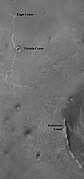
 Annotated image showing the position of Opportunity on March 7, 2009 and names for the craters Iazu, Endeavour, and Victoria.
 -
 On July 18, 2009 Opportunity eyed an oddly shaped, dark rock, which was found to be a meteorite.
 -
 Opportunity prepares to inspect the unusual rock, now dubbed Block Island. It is the largest meteorite found by a Martian rover so far.
 -
 Opportunity took this picture of a rock informally named 'Marquette Island' as it approached the rock for investigations that have suggested the rock ejecta from deep within Mars rather than a meteorite.


2010
Concepción
On January 28, 2010 (Sol 2138) Opportunity arrived at Concepcion crater.[69] Opportunity successfully circumnavigated the 10-meter (33 ft) diameter crater before continuing on towards Endeavour. Energy production varied from about 305 watt-hours to about 270 Wh during this period.[69]
On sol 2231 (May 5, 2010), due to potentially hazardous dune fields along the direct path between Victoria and Endeavour, a new route was charted that extended the distance to travel between the two craters to 19 kilometers (12 mi).[70]
On (May 19, 2010), Opportunity reached 2244 sols of operation, making it the longest Mars surface mission in history, breaking the record of 2245 sols set by Viking 1.[71]
Santa Maria crater
In July 2010, it was announced that the Opportunity team would use the theme of names given to places visited by British Royal Navy Captain, Lieutenant James Cook, in his 1769–1771 Pacific Ocean voyage in command of HMS Endeavour, for informal names of sites at Endeavour Crater. These would include "Cape Tribulation" and "Cape Dromedary", "Cape Byron" (the most easterly point of the Australian mainland), and "Point Hicks" (the part of the Australian mainland first sighted by the Endeavour in 1770).[72]
On sol 2353 (September 8, 2010), the halfway point of the 19 kilometers (12 mi) journey between Victoria crater and Endeavour crater was reached.[73]
In November the rover spent a few days imaging a 20 meters (66 ft) crater called Intrepid while navigating through a field of small impact craters. On sol 2419 November 14, 2010 total odometry passed the 25 kilometers (16 mi) mark. Average solar array energy production in October and November was about 600 watt-hours.[74]
On sol 2449 (December 15, 2010) the rover arrived at Santa Maria and spent several weeks investigating the 90 meters (300 ft) wide crater.[75] The results from Opportunity were compared to data taken from orbit by the CRISM instrument, a spectrometer, on the Mars Reconnaissance Orbiter.[75] CRISM had detected water-bearing minerals at Santa Maria crater, and the rover helped further analyze this.[75] Opportunity drove farther in that Martian year (that is about 2 Earth years), than in any previous year.[75]
.jpg)
2011
Heading to Endeavour crater
After its arrival at the edge of Santa Maria crater, the team positioned the rover at its southeastern rim and collected data.[76] They also prepared for the two-week solar conjunction of late January, when the Sun was between Earth and Mars and communication was blocked. In late March Opportunity began the 6.5 kilometers (4.0 mi) journey between Santa Maria and Endeavour, and on June 1, the rover passed the 30 kilometers (19 mi) traverse milestone (over 50 times its designed distance).[76][77] Two weeks later, on sol 2657 (July 17, 2011), Opportunity had driven 32 km (20 mi) on Mars.[78]
By sol 2699 (August 29, 2011), Opportunity had continued to function effectively 30 times longer than its planned 90-sol mission, aided by solar cell cleaning events, and performed extensive geological analysis of Martian rocks and planetary surface features with its instruments.[79]
Endeavour crater arrival
Opportunity arrived at Endeavour crater on sol 2709 (August 9, 2011), at a landmark called Spirit Point named after its rover twin, after traversing 21 km (13 mi) from Victoria crater, over a three-year period.[80] Endeavour is 23 km (14 mi) wide and offers scientists new terrain to explore, including older rocks than encountered heretofore, and clay minerals that may have formed in the presence of water. The rover's deputy principal investigator, Ray Arvidson, said it will probably not enter Endeavour crater as it appears to contain material observed previously. The rocks on the rim are older than any previously studied by Opportunity. "I think there's much more interest in driving around the perimeter of the rim," said Arvidson.[81]
Upon arriving at Endeavour, Opportunity almost immediately began discovering Martian phenomena not previously observed. On sol 2692 (August 22, 2011) the rover began examining Tisdale 2, a large ejecta block. “This is different from any rock ever seen on Mars," said Steve Squyres, principal investigator for Opportunity at Cornell University in Ithaca, New York. "It has a composition similar to some volcanic rocks, but there's much more zinc and bromine than we've typically seen. We are getting confirmation that reaching Endeavour really has given us the equivalent of a second landing site for Opportunity."[6][82]
-
 West Rim of Endeavour Crater
 -
 Spirit Point at Endeavour Crater
 -
 Opportunity examines Tisdale 2
 -
 "Homestake" formation


In December the Homestake formation was analyzed, which was concluded to be formed of gypsum. Using three of the rover's instruments - the Microscopic Imager, the Alpha Particle X-Ray Spectrometer and the Panoramic Camera's filters - researchers determined the deposit to be hydrated calcium sulfate, or gypsum, a mineral that does not occur except in the presence of water. This discovery was called "slam dunk" evidence that "water flowed through underground fractures in the rock." [83]
Opportunity had driven more than 34 km (21 mi) by November 22, 2011 (sol 2783), as preparations were made for the coming Martian winter.[84] It moved to terrain that positioned it about 15 degrees to the north, an angle more favorable for solar energy production during the Martian winter.[85]
2012
Greeley Haven

In January 2012 the rover returned data from Greeley Haven, named after the geologist Ronald Greeley, while enduring its 5th Martian winter.[85] It studied the Martian wind, which has been described as "the most active process on Mars today", and conducted a radio science experiment.[85] By carefully measuring radio signals, wobbles in Martian rotation may show whether the planet has a solid or liquid interior.[85] The winter work site sits on the Cape York segment of the rim of Endeavor Crater. Opportunity reached the edge of this 23 km (14 mi) crater in August after three years of driving from smaller Victoria Crater, which it studied for two years.[86]
On Sol 2852 (February 1, 2012) the energy production from the solar array was 270 watt-hours, with a Mars atmospheric opacity (Tau) of 0.679, a solar array dust factor of 0.469, with total odometry at 34.36 km (21.35 mi).[87] By March (around Sol 2890), 'Amboy' rock was studied with the MIMOS II Mössbauer spectrometer and the Microscopic Imager, and the amount of Argon gas in the Martian air was measured.[88] The Mars winter solstice passed on March 30, 2012 (Sol 2909) and on April 1 there was a small cleaning event.[89] On Sol 2913 (April 3, 2012) solar array energy production was 321 watt-hours.[89]
The mission of Mars rover Opportunity continued, and by May 1, 2012 (Sol 2940), energy production had increased to 365 watt-hours, with the solar array dust factor at 0.534.[90] The team prepared the rover for movement and finished up collecting data on Amboy rock.[90] 60 Doppler radio passes were completed over the winter.[91]
On May 8, 2012 (Sol 2947), the rover moved 12 feet (3.7 m).[92] On that day the Solar energy production was 357 watt-hours with a solar array dust factor of 0.536.[92] Opportunity had been stationary on Greeley Haven for 130 Sols (Mars' days), with a 15 degrees tilt to the North to help survive the winter; after the drive the northerly tilt decreased to 8 degrees.[92] The drive marked the end of the geodynamics science experiment, which used radio Doppler measurements while the rover was stationary.[92] By June 2012, it studied Mars dust and a nearby rock vein christened "Monte Cristo" as it headed North.[91]
Exploring Matijevic hill at Cape York
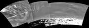
On July 2, 2012 Opportunity's 3000 Sols on Mars were celebrated.[93] By July 5, 2012, NASA published a new panorama (seen below) showing the surroundings of Opportunity at the Greeley Haven position.[94] Also, the other end of the Endeavour crater is seen in the right half of the scene, a crater that spans 22 kilometers (14 mi) in diameter. On July 12, 2012 (Sol 3010), solar arrays produced 523 watt-hours and 34,580 m (21.49 mi) was the total distance traveled from landing.[95] That month, Mars Reconnaissance Orbiter spotted a dust storm and water ice clouds near the rover.[95]

Before Curiosity landed on August 6, 2012, Opportunity sent special Ultra High Frequency radio signals to simulate Curiosity for a radio observatory in Australia.[93] August activities for Opportunity included collecting data on atmospheric opacity,[93] visiting Sao Rafael and Berrio craters,[96] and achieving 35 kilometers (22 mi) of driving on Sol 3056 (August 28, 2012).[97] Also, on August 19, 2012 Mars Express orbiter automatically exchanged data with both Curiosity and Opportunity in one orbit, its first double contact.[98]

In the fall Opportunity headed south, exploring Matijevic hill and searching for phyllosilicate minerals.[97] Some data was sent to Earth directly using X-Band radio signals, as opposed to orbiter relays.[97] Finally, the number of power cycles on the rover's Inertial Measurement Unit were reduced.[97] Science work included testing various hypotheses about the newly discovered spherules.[99]
A small dust cleaning event occurred on Sol 3175 (Dec. 29, 2012), improving the energy production by about 40 watt-hours per sol. As of Sol 3180 (Jan. 3, 2013), the solar array energy production was 542 watt-hours with an atmospheric opacity (Tau) of 0.961 and an improved solar array dust factor of 0.633.
— NASA[100]
2013
Leaving Cape York

Opportunity began the year at the edge of Endeavour Crater's Cape York,[100] and the total distance travelled since landing on Mars was 35 km (22 mi).[100][101] After completing work at Matijevic Hill the Opportunity rover headed south to the rim of Endeavour Crater. Next, the rover headed south across a gap in the rim to a place the researchers called Botany Bay, then up onto the next rim segment to the south. There are two hills to the south of it, one called Solander Point and farther south is Cape Tribulation.[102] The current aim is for Opportunity to reach Solander Point before winter reaches the Martian southern hemisphere as the area has ground tilted to the north allowing the rover to stay active during the winter months. In addition Solander Point has a large geological stack for Opportunity to explore.[103] In April 2013, the rover passed through a three-week long solar conjunction, when communication with Earth was blocked because of the Sun.[104] The rover arm was positioned on a rock during that time so the APXS could collect data.[104]
On May 16, 2013, NASA announced that Opportunity had driven further than any other NASA vehicle on a world other than Earth.[105] After Opportunity's total odometry went over 35.744 kilometers (22.210 mi) it surpassed the total distance driven by the Apollo 17 Lunar Roving Vehicle.[105] The record for longest distance driven by a vehicle on another world is currently held by the Lunokhod 2 lunar rover.[105] Based on wheel rotations Lunokhod 2 was thought to have covered 37 kilometers (23 mi), but Russian scientists have revised that to an estimated distance of about 42 kilometers (26 mi) based on orbital images of the lunar surface.[106][107]
On May 17, 2013, NASA announced that a preliminary analysis of one of the rock targets, named "Esperance", suggested that water in the past may have had a neutral pH.[108] This was later confirmed in further studies, supporting the notion that ancient Mars was a "water-rich world with conditions amenable for life".[109] As of June 20, 2013 (Sol 3344), Opportunity's total odometry was reported at 36.84 km (22.89 mi), while en route to 'Solander Point.'[110] June 21, 2013 marked five Martian years on the 'red planet'.[111] The project manager, noting the harsh conditions of the planet, has said each day is "a gift".[112]
Solander Point
By early July 2013 Opportunity was approaching Solander Point, with daily drives ranging from dozens of meters (yards) to over a hundred.[114] It arrived at its base in early August 2013, after investigating a curious terrain patch along the way.[115] Solander can provide a northward facing slope to aid in sunlight collection, as the Martian winter is approaching (as the season changes, the angle of the Sun is shifting).[115] On Sol 3390 (August 6, 2013) energy intake was 385 watt-hours, down from 395 on Sol 3384 (July 31, 2013), and 431 on Sol 3376 (July 23, 2013).[115] In May 2013 it had been as high as 546 watt-hours.[115] Other factors that impact collection include the atmospheric opacity (i.e. "Tau") and "solar array dust factor"—dust that collects on the panels.[115] Although the rover cannot clean the dust off, such systems were considered for the rover during its development.[116]
In September, numerous surface targets and rocks around Solander were examined by the rover.[115] Solar array energy production dropped to 346 watt-hours by Sol 3430 (September 16, 2013),[115] and 325 watt-hours by Sol 3452 (October 9, 2013).[117] By traveling to locations with favorable tilt, dubbed "lily pads", Opportunity managed to receive over about 300 watt-hours per day even as the heart of the Mars winter approached.[118] The Martian winter minimum is predicted for February 2014, but by making use of the northward slopes it is expected the rover will have enough power to remain mobile during the Martian winter.[119] By the end of October the rover was climbing up Solander point, where it is hoped some of the oldest rocks yet seen will be examined.[120] The rocks are believed to date to Mars's Noachian Period about 4 billion years ago, and may provide some science surprises by Christmas.[121] The team is hunting for "juicy" slopes of 5 to 20 degrees for more power.[121]

As it ascended, it doglegged in early November to avoid an area of dusty ripples.[118] It continued to collect data on Martian rocks and dust in the area.[118] Total odometry by November 5, 2013, or in Mars day since the landing, Sol 3478, was 23.94 miles (38.53 kilometers).[118] Energy production from the Sun on that date was 311 watt-hours, with Tau at 0.536 and the dust factor at 0.491.[118]
| Date | Watt-hours |
|---|---|
| Sol 3376 (July 23, 2013) | |
| Sol 3384 (July 31, 2013) | |
| Sol 3390 (August 6, 2013) | |
| Sol 3430 (September 16, 2013) | |
| Sol 3452 (October 9, 2013) | |
| Sol 3472 (October 30, 2013) | |
| Sol 3478 (November 5, 2013) | |
| Sol 3507 (Dec. 5, 2013) | |
| Sol 3534 (Jan. 1, 2014) |
Before Spirit rover stopped responding in 2010, it reported 134 watt-hours as temperatures plunged below minus 41.5 degrees Celsius (minus 42.7 degrees Fahrenheit).[122]
By early December power levels had hit 270 watt-hours per day, even as it climbed higher up the ridge.[123] It maintained a northerly tilt to increase energy production on Solander point.[124] In early December one of the communication relay satellites at Mars, Odyssey, had some difficulties so the rover sent its telemetry directly to Earth.[124] The orbiter returned to operation after December 10, 2013 and the rover prepared for additional drives.[124] On Sol 3521 (Dec. 19, 2013) the rover took micro-images and used the Alpha Particle X-ray Spectrometer.[125] Between December 31 and New Year's Day cleaning events removed dust, improving the Solar Array Dust Factor to 0.566 (where higher is better and 1.0 is totally clean).[125] Energy production increased 35 watt-hours/day after this cleaning, to 371 watt-hours/day.[125]


2014


Opportunity started off 2014 on the western ridge of Endeavour crater, providing elevated panoramas of the surrounding region.[125] Research on data from Mars orbiters identified interesting minerals on the outcrop.[125] Some communication and difficulties the previous month delayed investigating these rocks, but on the positive side, the wait, along with a cleaning event over January 1, allowed for more electrical power to be available.[125] The rover is tilted towards the Sun to help it get more power, and it is expected that it can remain active during the Martian winter.[119]
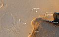
On January 17, NASA reported that a rock, named "Pinnacle Island", that was not in a rover image taken on Sol 3528, "mysteriously" appeared 13 days later in a similar image taken on Sol 3540. One possible explanation, presented by Steven Squyres, principal investigator of the Mars Exploration Rover Mission, was that the rover, in one of its turning motions, flicked the rock from a few meters away and into the new location.[126][127]
In response, Rhawn Joseph published an article in the fringe journal Journal of Cosmology on January 17, 2014,[129] and filed a writ of mandamus on January 27, 2014 in San Francisco Federal Court, stating that the object is a living entity and demanded that NASA re-examine the rock more closely.[130][131][132] However, NASA already had examined the rock with the rover's microscope[132] and analyzers, and confirmed it was a rock with a high sulphur, manganese, and magnesium content.[128] According to Steven Squyres, "We have looked at it with our microscope. It is clearly a rock."[132] On February 14, 2014, NASA released an image showing the location from where the "Pinnacle Island" rock was dislodged by the Opportunity rover.
On January 23, 2014, NASA celebrated the tenth anniversary (officially, January 25, 2014) of the rover's landing on Mars by sharing a self-portrait of the rover from above.[14]
On January 23, 2014, NASA reported on the latest discoveries of some Martian rocks and stated, "These rocks are older than any we examined earlier in the mission, and they reveal more favorable conditions for microbial life than any evidence previously examined by investigations with Opportunity."[133][134][135]
On January 24, 2014, NASA reported that current studies on the planet Mars by the Curiosity and Opportunity rovers will now be searching for evidence of ancient life, including a biosphere based on autotrophic, chemotrophic and/or chemolithoautotrophic microorganisms, as well as ancient water, including fluvio-lacustrine environments (plains related to ancient rivers or lakes) that may have been habitable.[135][136][137][138] The search for evidence of habitability, taphonomy (related to fossils), and organic carbon on the planet Mars is now a primary NASA objective.[136]
| Date | Watt-hours |
|---|---|
| Sol 3534 (Jan. 1, 2014) | |
| Sol 3602 (March 12, 2014) |
Among many activities in March, the rover studied the rock Augustine and on Sol 3602 (March 12, 2014), produced 498 watt-hours from sunlight.[139]
Scientific findings
Opportunity has provided substantial evidence in support of the mission's primary scientific goals: to search for and characterize a wide range of rocks and soils that hold clues to past water activity on Mars. In addition to investigating the water, Opportunity has also obtained astronomical observations and atmospheric data.
Honors
Honoring Opportunity's great contribution to the exploration of Mars, the asteroid 39382 has been named Opportunity.[140] The name was proposed by Ingrid van Houten-Groeneveld who, along with Cornelis Johannes van Houten and Tom Gehrels, discovered the asteroid on September 24, 1960. Opportunity's lander is Challenger Memorial Station.[15]
Pictures
The rover can take pictures with its different cameras, but only the PanCam camera has the ability to photograph a scene with different color filters. The panorama views are usually built up from PanCam images. Up November 20, 2013, Opportunity rover returned 186,246 pictures.[141]
Views
-
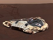 Image taken by the panoramic camera aboard Opportunity showing the rover's empty lander, the Challenger Memorial Station.
 -
 Cirrus clouds in the Martian sky
 -
 Pancam view from August 2012 (Sol 3058)
 -
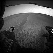
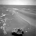
![Solander Point is visible on the horizon, and the foreground reveals the terrain of Botany Bay; there is about 1.0 m (3.3 ft) between the wheels.[142]](http://178.128.105.246/cars-http-upload.wikimedia.org/wikipedia/commons/thumb/a/a4/Pia17271_sol3355-rearhaz_3.jpg/180px-Pia17271_sol3355-rearhaz_3.jpg) Solander Point is visible on the horizon, and the foreground reveals the terrain of Botany Bay; there is about 1.0 m (3.3 ft) between the wheels.[142]
Solander Point is visible on the horizon, and the foreground reveals the terrain of Botany Bay; there is about 1.0 m (3.3 ft) between the wheels.[142]


![Solander Point is visible on the horizon, and the foreground reveals the terrain of Botany Bay; there is about 1.0 m (3.3 ft) between the wheels.[142]](http://178.128.105.246/cars-https-en.wikipedia.org/wiki/File:Pia17271_sol3355-rearhaz_3.jpg)
Panoramas


Microscopic images
-
 "Blueberries" (hematite spheres) on a rocky outcrop at Eagle Crater. Note the merged triplet in the upper left.
 -
 "Newberries": This view displays an area about 6 centimeters across. It was taken at an outcrop named Kirkwood at the Cape York on the rim of Endeavour crater on Mars. The spheres seen here are about 3 millimeters in diameter. The Microscopic Imager took this image at the 3064 sol.

From orbit
-
 Opportunity landing site, lander, as imaged by MRO
(November 29, 2006) -
 Opportunity landing site, parachute and backshell, as imaged by MRO (November 29, 2006)
 -
 Opportunity landing site, heat shield, as imaged by MRO
(November 29, 2006) -
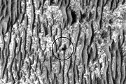 Opportunity (circled) as seen by HiRISE on January 29, 2009. Endeavour Crater is 17 km (11 mi) away.


Maps
-
 Opportunity traverse map, from sol 1 (2004) through sol 2055 (2009)
 -
 Annotated Opportunity traverse map as of December 8, 2010 (Sol 2442)
 -
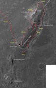 Opportunity's traverse on Cape York from Sol 2678 to Sol 3317 with some additional annnotations of the main features.


See also
|
|
References
- ^ a b c Nelson, Jon. "Mars Exploration Rover - Opportunity". NASA. Retrieved February 2, 2014.
- ^ a b "Launch Event Details – When did the Rovers Launch?". Retrieved April 25, 2009.
- ^ "Mars Exploration Rover project, NASA/JPL document NSS ISDC 2001 27/05/2001" (PDF). p. 5. Retrieved April 28, 2009.
- ^ Jonathan McDowell (July 15, 2003). "Jonathan's Space Report No. 504". Jonathan's Space Report. Retrieved April 28, 2009.
- ^ "Spirit" landed on January 4, 2004.
- ^ a b Tony Fitzpatrick - Opportunity on verge of new discovery
- ^ The scientific objectives of the Mars Exploration Rover
- ^ Chang, Kenneth (November 7, 2004). "Martian Robots, Taking Orders From a Manhattan Walk-Up". The New York Times. Retrieved April 9, 2009.
- ^ Squyres, Steve (2005). Roving Mars: Spirit, Opportunity, and the Exploration of the Red Planet. Hyperion Press. pp. 113–117. ISBN 978-1-4013-0149-1.
- ^ "MER - Batteries and Heaters". Jet Propulsion Laboratory. NASA. Retrieved August 13, 2012.
- ^ "Opportunity Update Archive". NASA/JPL. Retrieved May 4, 2009.
- ^ "NASA - NASA Mars Rover Arrives at New Site on Martian Surface". Nasa.gov. Retrieved July 15, 2012.
- ^ "Opportunity Updates". Retrieved July 31, 2012.
- ^ a b c "NASA Facts: Mars Exploration Rover" (PDF). NASA/JPL. October 24, 2004. Retrieved March 26, 2009.
- ^ a b "Space Shuttle Challenger Crew Memorialized on Mars". Retrieved July 24, 2008.
- ^ "Scientists Thrilled To See Layers in Mars Rocks Near Opportunity". Retrieved July 8, 2006.
- ^ "Embedded in it like blueberries in a muffin are these little spherical grains", said Dr. Steve Squyres of Cornell University, Ithaca, N.Y., principal investigator for the rovers' scientific instruments. He also said: "One other treasure, a clue that just popped up, not gonna quote any numbers yet, but we have now completed an APXS measurement on the outcrop and it has got a lot of sulfur in it. Maybe a few times more sulfur than we've seen on any other location on Mars." [1]
- ^ Moffett field (February 25, 2004). "El Capitan Is That A Rock Or What". Space Daily. Retrieved August 5, 2010.
- ^ "Opportunity Rover Finds Strong Evidence Meridiani Planum Was Wet". Retrieved July 8, 2006.
- ^ "Opportunity Digs; Spirit Advances". Retrieved July 8, 2006.
- ^ "Opportunity Examines Trench As Spirit Prepares To Dig One". Retrieved August 7, 2006.
- ^ S. Squyres, et al., "The Opportunity Rover's Athena Science Investigation At Meridiani Planum, Mars," Science, Vol. 306, Issue 5702, 1698–1703 (December 3, 2004).
- ^ "Opportunity Arrives at 'Endurance Crater'". Retrieved August 9, 2011.
- ^ "Opportunity Digs, Scuffs, and Cruises". Retrieved August 9, 2011.
- ^ "Mars Rover Opportunity Gets Green Light To Enter Crater". Retrieved July 7, 2006.
- ^ "Opportunity Takes A Dip". Retrieved August 9, 2011.
- ^ "Out of 'Endurance'". Retrieved August 9, 2011.
- ^ S. W. Squyres and A. H. Knoll, Sedimentary Geology at Meridiani Planum, Mars, Elsevier, Amsterdam, ISBN 978-0-444-52250-4 (2005); reprinted from Earth and Planetary Science Letters, Vol. 240, No. 1 (2005).
- ^ "Hovering Near Heat Shield and a Holey Rock". Retrieved August 9, 2011.
- ^ "Opportunity Continues on the Plains After Marking One Year on Mars". Retrieved August 9, 2011.
- ^ "Opportunity Continues to Set Martian Records". NASA/JPL. March 31, 2005. Retrieved April 26, 2009.
- ^ "Durable Mars Rovers Sent Into Third Overtime Period". NASA/JPL. April 5, 2005. Retrieved April 26, 2009.
- ^ "Mars rover mission extended". CNN. April 7, 2005. Retrieved April 26, 2009.
- ^ "Opportunity Update: Opportunity Backs Out of Potentially Sticky Situation (October 11, 2005)". Retrieved June 3, 2006.
- ^ a b "PIA08813: 'Victoria Crater' at Meridiani Planum". Retrieved June 28, 2010.
- ^ a b c "PIA13088: Opportunity's Wheel Tracks at Victoria Crater". Retrieved June 28, 2010.
- ^ "NASA Mars Rover Arrives at Dramatic Vista on Red Planet". Retrieved September 30, 2006.
- ^ "Mars orbiter looks down on rover". BBC News. October 6, 2006. Retrieved November 15, 2007.
- ^ "Old rovers learn new tricks". CBC News. January 4, 2007.
- ^ [2]
- ^ [3]
- ^ "Opportunity Status Updates: Sols 1152–1156, 1157–1163, and 1164–1170". Retrieved May 7, 2007.
- ^ "'Scary Storm' on Mars Could Doom Rovers". Retrieved July 15, 2007.
- ^ JPL.NASA.GOV: News Releases
- ^ Mars Exploration Rover Mission: Press Releases
- ^ "Martian Skies Brighten Slightly". Retrieved August 8, 2007.
- ^ "Mars Exploration Rover Status Report: Rovers Resume Driving". Retrieved September 13, 2007.
- ^ "Opportunity Takes A Dip Into Victoria Crater". Retrieved September 13, 2007.
- ^ Mars Exploration Rover Mission: All Opportunity Updates
- ^ A.J.S Rahl (August 31, 2008). "Opportunity Exits Victoria Crater, Spirit Picks Up Pace on Panorama". Planetary Society. Retrieved September 16, 2008. [dead link]
- ^ a b c "Mars Exploration Rover to head toward bigger crater". Retrieved September 22, 2008.
- ^ "Opportunity Prepares for Two Weeks of Independent Study". NASA/JPL. Retrieved November 30, 2008.
- ^ "One Mars Rover Sees A Distant Goal; The Other Takes A New Route". NASA/JPL. March 18, 2009. Retrieved March 20, 2009.
- ^ a b "One Mars Rover Sees A Distant Goal; The Other Takes A New Route". NASA/JPL. March 18, 2009. Retrieved March 20, 2009.
- ^ a b "Cleaning Event Boosts Energy". NASA/JPL. April 8, 2009. Retrieved April 9, 2009.
- ^ a b "Five Long Drives". NASA/JPL. April 22, 2009. Retrieved April 24, 2009.
- ^ "At Outcrop with Endeavour in Sight". NASA/JPL. March 19, 2009. Retrieved April 24, 2009.
- ^ "Brushing and Examining an Outcrop". NASA/JPL. March 25, 2009. Retrieved April 24, 2009.
- ^ "Examining Rock's Interior". NASA/JPL. March 31, 2009. Retrieved April 24, 2009.
- ^ "Five Long Drives". NASA/JPL. April 15, 2009. Retrieved April 24, 2009.
- ^ "Heading Toward 'Block Island' Cobble". NASA/JPL. Retrieved August 9, 2011.
- ^ "Departing Block Island". NASA/JPL. Retrieved August 9, 2011.
- ^ "Opportunity Knocks with Another Meteorite Find". NASA/JPL. Retrieved August 9, 2011.
- ^ "A Meteorite Called 'Mackinac'". NASA/JPL. Retrieved August 9, 2011.
- ^ "Approaching "Marquette Island"". NASA/JPL. Retrieved August 9, 2011.
- ^ "Leaving Marquette Behind". NASA/JPL. Retrieved August 9, 2011.
- ^ "Preparing to Grind". NASA/JPL. Retrieved August 9, 2011.
- ^ a b "Driving to 'Concepcion' Crater". NASA/JPL. January 20, 2010. Retrieved January 30, 2010.
- ^ "Opportunity's Long and Winding Road to Endeavour Crater". Universe Today. May 5, 2010. Retrieved August 4, 2010.
- ^ "Opportunity rover breaks Mars longevity record". Retrieved August 4, 2010.
- ^ "Opportunity To See More Detail At Crater Destination". Marsdaily.com. June 30, 2010. Retrieved July 2, 2010.
- ^ "Opportunity Rover Reaches Halfway Point of Long Trek". NASA/JPL. September 8, 2010. Retrieved September 11, 2010.
- ^ sols 2418–2423, November 12–17, 2010 NASA/JPL November 17, 2010
- ^ a b c d NASA Spacecraft Provides Travel Tips for Mars Rover NASA/JPL December 16, 2010
- ^ a b NASA JPL Opportunity Updates: 2011 (Opportunity Rover Update Archive)
- ^ "NASA - Opportunity Passes Small Crater and Big Milestone". Nasa.gov. Retrieved July 15, 2012.
- ^ NASA's Opportunity Tops 20 Miles of Mars Driving Jet Propulsion Laboratory, July 19, 2011.
- ^ "Opportunity Mission Manager Update". Retrieved September 12, 2011.
- ^ NASA Mars Rover Arrives at New Site on Martian Surface Jet Propulsion Laboratory, August 10, 2011.
- ^ NASA Rover Arrives at Huge Mars Crater After 3-Year Trek Space.com, August 10, 2011.
- ^ "NASA's Mars Rover Opportunity begins study of Martian crater". DefenceWeb. September 6, 2011. Retrieved July 15, 2012.
- ^ Opportunity finds more evidence of water on Mars
- ^ "NASA Opportunity rover updates". NASA. November 22, 2011. Retrieved November 29, 2011.
- ^ a b c d "NASA - Durable NASA Rover Beginning Ninth Year of Mars Work". January 24, 2012.
- ^ "'Greeley Haven' is Winter Workplace for Mars Rover". nasa.gov. January 5, 2012.
- ^ JPL - Opportunity daily
- ^ Opportunity Status Sol 2887 (NASA)
- ^ a b "NASA Sol 2907".
- ^ a b "NASA Sol 2935".
- ^ a b NASA - Robotic Arm Gets to Work on Veins of Gypsum
- ^ a b c d "Opportunity on the Road Again!". Retrieved May 11, 2012.
- ^ a b c NASA - With Curiosity on the Surface Opportunity Will Resume Driving Soon
- ^ "'Greeley Panorama' from Opportunity's Fifth Martian Winter (False Color)". Retrieved July 7, 2012.
- ^ a b NASA - Slow-Going for Opportunity This Week
- ^ Opportunity is on the Move Again!
- ^ a b c d More Driving And Imaging At 'Matijevic Hill'
- ^ Mars Express - Mars Express rocking and rolling with NASA’s Curiosity & Opportunity by T. Ormston - 2012
- ^ NASA - ars Rover Opportunity Working at 'Matijevic Hill' - September 28, 2012
- ^ a b c NASA - Sol 3174
- ^ Mars Daily Staff - Opportunity Scores Another Dust Cleaning Event At Vermillion
- ^ Harwood, William (January 25, 2013). "Opportunity rover moves into 10th year of Mars operations". Space Flight Now. Retrieved February 18, 2013.
- ^ NASA - Mars Rover Opportunity Trekking Toward More Layers
- ^ a b NASA - Sol 3291
- ^ a b c "Nine-Year-Old Mars Rover Passes 40-Year-Old Record". NASA/JPL. May 16, 2013. Retrieved May 25, 2013.
- ^ Lakdawalla, Emily (June 21, 2013). "Is Opportunity near Lunokhod's distance record? Not as close as we used to think!". The Planetary Society. Retrieved June 26, 2013.
- ^ Witze, Alexandra (June 19, 2013). "Space rovers in record race". Nature News. Retrieved June 26, 2013.
- ^ Webster, Guy; Brown, Dwayne (May 17, 2013). Mars Rover Opportunity Examines Clay Clues in Rock "Mars Rover Opportunity Examines Clay Clues in Rock". NASA. Retrieved June 8, 2013.
{{cite web}}: Check|url=value (help) - ^ Chang, Kenneth (June 7, 2013). "Martian Rock Another Clue to a Once Water-Rich Planet". New York Times. Retrieved June 7, 2013.
- ^ "sols 3340-3344, Jun. 16, 2013-Jun. 20, 2013: Opportunity is Healthy and Driving to 'Solander Point'". NASA/JPL. June 20, 2013. Retrieved June 24, 2013.
- ^ NASA - Sol 3340
- ^ Universe Today - Opportunity Rover Discovers Martian Habitable Zone Favorable for Pre-biotic Chemistry by K. Kremer
- ^ PIA17078: Opportunity's view of 'Solander Point'
- ^ NASA - Sol 3351
- ^ a b c d e f g NASA - Sol 33591 Cite error: The named reference "sol3391" was defined multiple times with different content (see the help page).
- ^ Why don't the Mars rovers have dust wipers? - New Scientist (2008)
- ^ NASA - Sol 3445
- ^ a b c d e NASA - Sol 3473
- ^ a b NASA - Mars Rover Opportunity Working at Edge of 'Solander'
- ^ a b NASA -Mars Rover Opportunity Heads Uphill
- ^ a b TPS - A.J.S. Rayl - Mars Exploration Rovers Update: Opportunity Gets Back to the Past at Winter Site : Sols 3444 - 3473
- ^ NASA - Sprit Sol 2204
- ^ NASA - Sol 3499
- ^ a b c NASA - Sol 3508
- ^ a b c d e f NASA - 3520
- ^ a b O'Neill, Ian (January 17, 2014). "Mystery Rock 'Appears' in Front of Mars Rover". Space.com. Retrieved January 18, 2014.
- ^ a b Chang, Kenneth (January 24, 2014). "Mars Rover Marks an Unexpected Anniversary With a Mysterious Discovery". New York Times. Retrieved January 24, 2014.
- ^ a b Staff (January 24, 2014). "Scientist closer to solving Mars rock mystery, says NASA exper". The Telegraph. Retrieved January 31, 2014.
- ^ Joseph, Rhawn Gabriel (January 17, 2014). "Apothecia on Mars? Life Discovered on the Red Planet". Journal of Cosmology. Retrieved February 1, 2014.
- ^ Lecher, Colin (January 28, 2014). "Lawsuit Alleges NASA Is Failing To Investigate Alien Life". Popular Science. Retrieved January 31, 2014.
- ^ Weiss, Debra Cassens (January 29, 2014). "Suit says NASA was 'recklessly negligent and bizarre' for failing to investigate Mars rock". American Bar Association. Retrieved January 31, 2014.
- ^ a b c Bailey, Lorraine (January 29, 2014). "Is Mysterious Mars Rock a Fungus?". Courthouse News Service. Retrieved January 31, 2014. Cite error: The named reference "CHN-20140129" was defined multiple times with different content (see the help page).
- ^ Brown, Dwayne; Webster, Guy (January 23, 2014). "NASA's Opportunity at 10: New Findings from Old Rover". NASA. Retrieved January 24, 2014.
- ^ "Ancient Aqueous Environments at Endeavour Crater, Mars". Science. 343 (6169). January 24, 2014. doi:10.1126/science.1248097. Retrieved January 24, 2014.
{{cite journal}}: Unknown parameter|authors=ignored (help) - ^ a b "Special Collection - Curiosity - Exploring Martian Habitability". Science. January 24, 2014. Retrieved January 24, 2014.
{{cite journal}}: Unknown parameter|authors=ignored (help) - ^ a b Grotzinger, John P. (January 24, 2014). "Introduction to Special Issue - Habitability, Taphonomy, and the Search for Organic Carbon on Mars". Science. 343 (6169): 386–387. doi:10.1126/science.1249944. Retrieved January 24, 2014.
- ^ "Special Issue - Table of Contents - Exploring Martian Habitability". Science. 343 (6169): 345–452. January 24, 2014. Retrieved January 24, 2014.
{{cite journal}}: Unknown parameter|authors=ignored (help) - ^ "A Habitable Fluvio-Lacustrine Environment at Yellowknife Bay, Gale Crater, Mars". Science. 343 (6169). January 24, 2014. doi:10.1126/science.1242777. Retrieved January 24, 2014.
{{cite journal}}: Unknown parameter|authors=ignored (help) - ^ NASA - Sol 3596
- ^ "Mars Exploration Rover Mission; "Like Rover, Like Asteroid"". Retrieved June 9, 2008.
- ^ Opportunity: All Raw Images
- ^ Opportunity's View in 'Botany Bay' Toward 'Solander Point'
External links
NASA links
- JPL's Mars Exploration Rover home page
- JPL's Mars Exploration Rover Mission page
- Opportunity Mission Profile by NASA's Solar System Exploration
- Mission Status updates from NASA JPL
MSSS and WUSTL links
- Finding Opportunity: high resolution images of landing site (Mars Global Surveyor – Mars Orbiter Camera)
- MER Analyst's Notebook, Interactive access to mission data and documentation
Other links
- Wikisource:MER press briefing, January 28, 2004
- Full-page, high-res spherical panorama of Opportunity in Erebus Crater, nasatech.net, Nov 23, to Dec 5, 2005 (long download, uses Java)
- Full-page, high-res spherical panorama of Opportunity in Victoria Crater, nasatech.net, October 23 to December 11, 2007 (long download, uses Java)
- Finding Opportunity: interactive Mars atlas based on Viking images: you can zoom in/out and pan images, to find your preferred site (has broken links)
- MER Imagery: automatically generated 3D s/imagerghtereo anaglyphs and pseudo-color images based on JPL raw images
- (AXCH) 2004 Mars Exploration Rovers Highlights – News, status, technical info, history, and more.
- Unmanned Spaceflight.com discussion on Opportunity
- Road to Endeavour travelogue blog
- Mars Exploration Rover Manual (Unofficial)
- Video (02:59): Opportunity's View Of Three-Year 13-Mile Trek Across Mars (309-Images)
- Latest images (Midnightplanets.com)
Image map of Mars
The following imagemap of the planet Mars has embedded links to geographical features in addition to the noted Rover and Lander locations. Click on the features and you will be taken to the corresponding article pages. North is at the top; Elevations: red (higher), yellow (zero), blue (lower).
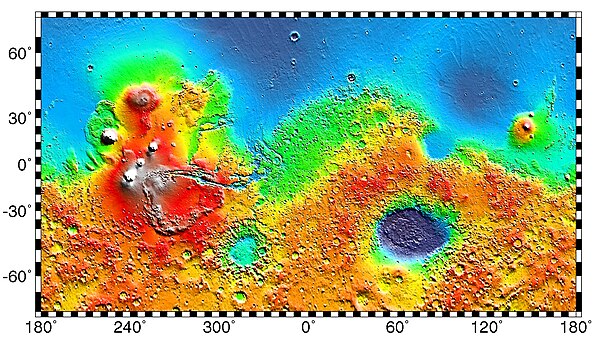
 Clickable image: Clicking on the labels will open a new article.
| General |
|  |
|---|---|---|
| Spirit rover | ||
| Opportunity rover | ||
| Instruments |
| |
| Related |
| |
| Active |
|  .jpg) .jpg) | |||||||||
|---|---|---|---|---|---|---|---|---|---|---|---|
| Past |
| ||||||||||
| |||||||||||
| Future |
| ||||||||||
| |||||||||||
| Exploration |
| ||||||||||
Missions are ordered by launch date. Sign † indicates failure en route or before intended mission data returned. | |||||||||||
| Geography |
| ||||||||||
|---|---|---|---|---|---|---|---|---|---|---|---|
| Astronomy |
| ||||||||||
| Exploration |
| ||||||||||
| Related | |||||||||||