Edukira joan

Fitxategi:Caloris high res.png

Orriaren edukia ez da onartzen beste hizkuntza batzuetan.
Wikipedia, Entziklopedia askea

Bereizmen handikoa((4.200 × 4.200 pixel, fitxategiaren tamaina: 18,05 MB, MIME mota: image/png))

Fitxategi hau Wikimedia Commonsekoa da. Hango deskribapen orriko informazioa behean duzu.
Commons gordailu bat da, lizentzia askea duten multimedia fitxategiena. Lagun dezakezu.

Fitxategi hau Wikimedia Commonsekoa da

Laburpena

Deskribapena
Русский: Равнина Жары на Меркурии. Мозаика из снимков Мессенджера, сделанных 14 января 2008
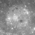
English: Caloris Planitia on Mercury. Mosaic of images, made by MESSENGER 14 January 2008.
This view is a mosaic of multiple MDIS images and shows the Caloris basin in its entirety. The Caloris basin was discovered in 1974 from Mariner 10 images, but when Mariner 10 flew by Mercury, only the eastern half of the basin was in daylight. During MESSENGER’s first Mercury flyby, the spacecraft was able to acquire high-resolution images of the entire basin, revealing the full extent of this great basin for the first time.
Geologists use the term "basin" to refer to an impact crater that is larger than about 300 kilometers (186 miles) in diameter and often displays multiple concentric rings. Caloris has one main topographic ring (1550-kilometer diameter). Patterns of concentric structures both inside and outside the main ring have been mapped and interpreted as evidence for additional rings. Caloris is one of the largest impact basins in the Solar System, and MESSENGER's orbital observations will provide much more data for this impressive geologic feature, including high-resolution color and low-Sun images for discerning morphology. This mosaic was obtained when the Sun was high overhead. Such lighting conditions emphasize brightness differences among the surface materials, with little shadowing to provide a sense of the texture and topography. The interior of the basin has been filled with lighter-hued plains, which in turn have been modified by impact craters. The craters range from small bright dots to larger craters with bright rays. Some of the larger craters exhibit dark rims. The dark rims suggest that dark material underlies the interior plains in some places and was exposed through the formation of those impact craters.
Date Acquired: January 14, 2008
Instrument: Narrow Angle Camera (NAC) of the Mercury Dual Imaging System (MDIS)
Scale: Caloris basin is 1,550 kilometers in diameter (960 miles)
Data
Jatorria

http://messenger.jhuapl.edu/gallery/sciencePhotos/image.php?image_id=394

http://photojournal.jpl.nasa.gov/catalog/PIA13675
Egilea NASA

Lizentzia

Public domain This file is in the public domain in the United States because it was solely created by NASA. NASA copyright policy states that "NASA material is not protected by copyright unless noted". (See Template:PD-USGov, NASA copyright policy page or JPL Image Use Policy.)
Warnings:

Irudi-oineko testuak

Add a one-line explanation of what this file represents

Fitxategi honetan agertzen diren itemak

honako hau irudikatzen du

14 urtarrila 2008

media type ingelesa

image/png

checksum ingelesa

b625a009e4960866b4ba3a414a4846405bf3a6ad

data size ingelesa

18.923.165 Byte

4.200 pixel

4.200 pixel

Fitxategiaren historia

Data/orduan klik egin fitxategiak orduan zuen itxura ikusteko.

Data/OrduaIruditxoaNeurriakErabiltzaileaIruzkina
oraingoa17:36, 2 abuztua 201417:36, 2 abuztua 2014 bertsioaren iruditxoa4.200 × 4.200 (18,05 MB)SneeuwschaapUser created page with UploadWizard

Hurrengo orrialdeek dute fitxategi honetarako lotura:

Fitxategiaren erabilera orokorra

Hurrengo beste wikiek fitxategi hau darabilte:

Metadatuak