Owu Nkurow Akɛse
| Native label | المدن المنسية |
|---|---|
| Culture | Byzantine Empire |
| Country | Syria |
| Located in/on physical feature | Limestone Massif |
| Coordinate location | 36°20′3″N 36°50′39″E |
| Significant event | list of World Heritage in Danger |
| Time period | late antiquity |
| Heritage designation | World Heritage Site |
| World Heritage criteria | (iii), (iv), (v) |

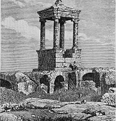
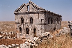
Owu Nkurow Akɛse (Arabic: المدن الميتة) anaa Nkurow a hɔn werɛ afi (Arabic: المدن المنسية) yɛ ekuw a ɔwɔ akuraase 700 a hɔn agyaw hɔ wɔ Syria atsifi atɔeɛ wɔ Aleppo na Idlib ntam. Nkuraase bɛyɛ 40 a hɔn aboaboa ano wɔ fam tutu mmɔntsen do atrae awɔtwe a ɔwɔ Syria atsifi fam atɔe no ma yehu nkuraase asetra wɔ Tsetse mber no awiei na Byzantium ber do. Wogyaw nkuraase dodow no ara a efi afeha a edzi kan kosi afeha a ɔtɔ do 7 mu no wɔ afeha a ɔtɔ do 8 na 10 ntam hɔ. Nkurow no kyerɛ adansi nkaeɛ a hɔn akora do yie a ɔfa adan, abosonsom asɔredan, asɔredan, abura, aguaree na nea ɔkeka ho Nkuropɔn a ewuwu a ɔho hia no bi nye Asɔre a ɔwɔ Saint Simeon Stylites, Serjilla na al Bara.
Owu Nkurow Akɛse no wɔ bea bi a ɔkorɔn a wɔdze abo a wɔfrɛ no limestone ayɛ a wɔfrɛ no Limestone Massif. Saa tsetse atraeɛ yi yɛ bea a nye tsɛtrɛtɛ yɛ kilomita 20–40 (akwansin 12–25) na nye tsentsen bɛyɛ kilomita 140 (akwansin 87). Mbepɔw akuw ebasa ka Massif no ho: nea edzi kan nye Bepɔw Simeon na Kurd Bepɔw a ɔwɔ atsifi fam kuw no; finimfin kuw a ɔtɔ do ebien nye Harim Mmepɔw kuw no; anafo fam kuw a ɔto do ebaasa na Zawiya Bepɔw kuw no.
Abakɔsɛm
[sesa mu | sesa ekyirsɛm]Chris Wickham, wɔ tumi mu nhwehwɛmu a ɔfa Roma ekyi wiadze no ho no, "Framing the Early Middle Ages" (2006) kyerɛ dɛ na eyinom yɛ akuafo a wodzi yiye atrae a ɔwɔ nkurow akɛse mu ndzɛmba pɔtsee kakraa bi anaadɛ ennyi bi koraa. Ɔman no mu adansi ho ndzɛmba a aka a ɔyɛ nwonwa no fi akuafo a wonyaa mfaso fii amanaman ntsam ngodua ngo aguadzi a emu yɛ dzen a ɔkɔɔ do wɔ Tsetse mber no awiei no mu bae.
Ekyingye foforo ne dɛ na eyinom yɛ nkurow a edzi yiye a ɔrenya nkɔdo osiandɛ na ɔwɔ aguadzi akwan atsitsir do wɔ Byzantium Ahemman no mu ntsi, na ɔnyɛ akuafo atrae a wodzi yiye ara kwa. Ber a Arabfo dzii do nkonyim ekyi no, aguadzi akwan no sesae, na dzea efii mu bae nye dɛ saa nkurow yi hweree aguadzi a ɔmaa hɔn sikasɛm nyaa nkɔdo no fa kɛse no ara. Wɔ saa adwene yi ho no, awiei koraa no, atubrafo gyaw hɔn nkurow no dze hɔn enyi kyerɛɛ nkurow afoforo a na ɔrenya nkɔdo wɔ Arabfo na Umayyadfo ase ber a nkurow akɛse a ɔrenya nkɔ anyim no gyee nye do nkɛntsɛndo no.
Tsetse nkuraase a na ɔwɔ Nkurow a ewu no mu no kyerɛ nsakrae a ɔbaa Roma Ahemman no tsetse abosonsomfo wiadze no mu kɔɔ Byzantium Kristosom mu.
Wɔkyerɛw Owu Nkurow Akɛse no dɛ UNESCO Wiadze Agyapadze Bea wɔ afe 2011 mu, wɔ dzin "Tsetse Nkuraase a Ɔwɔ Syria Atsifi Fam" ase.
Ansa na Syria Ɔmanko no reba no na ɔnyɛ dzen dɛ wobetumi akɔ mbea dodow no ara no, na hɔn akora nkurow a ewuwu no mu dodow no ara so yiye na na nsrahwɛfo tumi kɔ mbea no a wontua hwee, ɔwom dɛ ɔyɛ dzen yiye dɛ wobedu Nkurow a ewu no bi ho a wonnyi akwankyerɛ nwoma (akwankyerɛ nwoma bi wɔ hɔ dze). Abdallah Hadjar na ɔkyerɛwee a ɔwɔ asase mfonin a ɔkɔ akyir a mfaso wɔ do dɛ wobehu mbea a wonnyim pii no; St Simeon Stylites Asɔredan (The Church of St Simeon Stylites) na Fam tutu ho adesua mbea afofor a ɔwɔ Simeon na Halaqa Mbepɔw do.
Fam Tutu Ho Adesua Bea
[sesa mu | sesa ekyirsɛm]Owu Nkurow Akɛse na mbea a wotutu fam hwehwɛ tsetsefo ndzɛmba mu wɔ Limestone Massif no bi nye Asɔredan a ɔwɔ Ahotsefo Simeon Stylites, Serjilla, Bara, Basufan, Barisha, Qalb Loze, Barad, Cyrrhus, Turmanin, Banabil, Kafr Aruq, Kafr Dariyan, Babuline, Hazarin, Jarada, Maghara, Shinan, . Farkya, Ein Laruz, Ebla, Deir Sunbul, Al-Dana, Sarmada ne Al-Dana. Nyimpa a wɔste ase wɔ ber a wɔdze yɛ edwuma no mu.
Mount Simeon, Mount Kurd and Mount Ḥalqa
[sesa mu | sesa ekyirsɛm]| Name | Image | Coordinates | Governorate | Notes |
|---|---|---|---|---|
| Barad | 
|
36°23′8″N 36°53′57″E | Aleppo | An ancient settlement, located 32 km (20 mi) west of Aleppo, has many old basilicas; for example, the Saint Julianus Maronite monastery (399-402 AD) where the shrine of Saint Maron is located, and a basilica at the northern part of the village built in 561. |
| Barjaka or Burj Suleiman village | 
|
36°19′25.80″N 36°53′35.71″E | Aleppo | Located 26 km (16 mi) northwest of Aleppo. The site has remnants of an old hermit tower and a well-preserved chapel from the 6th century. |
| Basufan | 
|
36°20′26.69″N 36°52′33.11″E | Aleppo | |
| Batuta | 
|
36°18′21″N 36°53′14″E | Aleppo | Village founded in the 4th century. By the 6th century, it had two churches and more than twelve other stone buildings. |
| Baziher | 36°19′7″N 36°52′29″E | Aleppo | ||
| Benastur Monastery | 
|
36°18′12.00″N 36°55′23.00″E | Aleppo | |
| Churches of Sheikh Suleiman village | 
|
36°16′24.00″N 36°54′36.00″E | Aleppo | Located 28 km (17 mi) west of Aleppo, is notable for its three ancient churches: a ruined church located at the centre of the village, a well-preserved southern basilica which was built in 602, and the Church of the Virgin Mary which belongs to the late fifth century and is considered one of the most beautiful churches in northern Syria.[1] There is a hermit tower in the northern side of the village. |
| Church of Saint Simeon Stylites (Deir Semaan) | 
|
36°19′35.00″N 36°50′01.00″E | Aleppo | One of the most celebrated ecclesiastical monuments in Syria and among the oldest standing Christian churches in the world. It is located about 35 km (22 mi) northwest of Aleppo. |
| Cyrrhus | 
|
36°44′39″N 36°57′33″E | Aleppo | An ancient city located 65 km (40 mi) north of Aleppo, is the site of Saints Cosmas and Damian Church (commonly known as Nabi Houri church), as well as a Roman amphitheatre and two old Roman bridges. |
| Deir Amman churches | 36°12′8″N 36°49′18″E | Aleppo | ||
| Deir Mishmish Church | 
|
36°27′47″N 36°55′1″E | Aleppo | |
| Deir Turmanin | 
|
36°14′30″N 36°49′24″E | Idlib | The ruins of the Byzantine monastery of Deir Turmanin are built around a paved courtyard containing two cisterns, a sarcophagus and several tombs. They include a building that housed the monks' dormitories, and the large basilica built around 480 AD. |
| Fafertin Church | 36°19′13.79″N 36°54′26.41″E | Aleppo | A half-ruined Late Roman basilica dates to 372 AD; it is located 22 km (14 mi) northwest of Aleppo. According to the Aleppine historian Abdallah Hajjar, Fafertin Basilica is among the oldest dated churches in the world.[2] | |
| Kafr Kira settlement in Burj Heidar village | 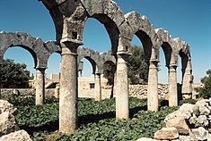
|
36°20′36.05″N 36°54′09.08″E | Aleppo | Located 24 km (15 mi) northwest of Aleppo, has many half-ruined Christian structures dating back to the fourth and sixth centuries. |
| Kafr Lab | 36°20′08.09″N 36°53′26.79″E | Aleppo | ||
| Kafr Lusein | 36°15′19.88″N 36°42′42.03″E | Aleppo | ||
| Kafr Nabu | 
|
36°21′36.54″N 36°54′28.88″E | Aleppo | Located 29 km (18 mi) west of Aleppo, is an Assyrian settlement of the ninth century BC and the site of a Roman temple which was converted into a church. There are also well-preserved residential buildings from the fifth and sixth centuries. |
| Kalota Castle and churches | 
|
36°21′18.22″N 36°56′33.51″E | Aleppo | Located 20 km northwest of Aleppo. The castle was originally built as a Roman temple during the 2nd century AD. After converting to Christianity, the temple was turned into a basilica within the 5th century.[3] As a result of the wars between the Hamadanids and the Byzantine Empire, the church was turned into a castle during the 10th century.[4] There are two well-preserved churches near the castle: the eastern church built in 492 and the western church of the 6th century. |
| Kharab Shams Basilica | 
|
36°20′22.0″N 36°56′34.0″E | Aleppo | One of the oldest best-preserved Christian structures in the Levant dates to the fourth century CE.[5] The Byzantine church is located 21 km (13 mi) northwest of Aleppo. |
| Kimar, near Basuta village | 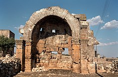
|
36°25′25.3″N 36°53′45.4″E | Aleppo | Located 35 km (22 mi) northwest of Aleppo, is a fifth-century CE village of the Late Roman and Byzantine eras; it has many well-preserved churches, towers and old water cisterns. |
| Mushabbak Basilica | 
|
36°15′17.00″N 36°53′01.00″E | Aleppo | A well-preserved church from the second half of the fifth century (around 470), is located 25 km (16 mi) west of Aleppo, near the town of Daret A'zzeh. |
| Qatura | 36°18′02.71″N 36°49′48.34″E | Aleppo | ||
| Refade | 
|
36°18′57″N 36°49′19″E | Idlib | |
| Sargible | 
|
36°14′17″N 36°42′59″E | Idlib | |
| Set al-Roum | 
|
36°18′37″N 36°50′3″E | Aleppo | |
| Sheikh Barakat | 36°16′40″N 36°49′18″E | Aleppo | ||
| Sinkhar historic settlement | 
|
36°17′52.00″N 36°54′30.00″E | Aleppo | Locally known as Simkhar, is located 24 km (15 mi) northwest of Aleppo in an isolated valley. The village was inhabited between the second and seventh centuries. Its Basilica is among the oldest churches in Syria and dates back to the fourth century, while the nearby chapel is sixth century. |
| Sugane village | 36°26′11.5″N 36°55′40.0″E | Aleppo | Located 40 km (25 mi) northwest of Aleppo, is home to two half-ruined churches and old water cisterns. | |
| Surqaniya village | 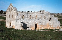
|
36°18′59.00″N 36°54′02.00″E | Aleppo | Located 23 km (14 mi) northwest of Aleppo, preserves the remains of an old Byzantine settlement with a half-ruined sixth-century chapel. |
| Taladah Church and Monastery | 36°15′5″N 36°48′4″E | Idlib | ||
| Taqla | 
|
36°19′09.96″N 36°50′51.03″E | Aleppo | |
| Zarzita | 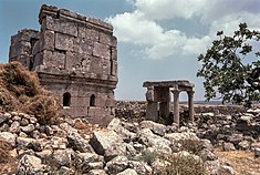
|
36°17′34.24″N 36°48′03.48″E | Aleppo |
Harim Mountains (Mount Bārīshā and Mount Aʻlā)
[sesa mu | sesa ekyirsɛm]Hwɛ iyi Nso
[sesa mu | sesa ekyirsɛm]- ↑ "Walking through the ruins". Jamahir News (in Arabic). Archived from the original on 2012-03-08.
- ↑ "Aleppo Fafertin Church". Esyria.sy. Retrieved 2013-06-10.
- ↑ "Aleppo: Kalota village". Esyria.sy. Retrieved 2013-06-10.
- ↑ "Kalota Church". Qenshrin. Retrieved 2013-06-10.
- ↑ "Kharab Shams in history". Esyria.sy. 2008-12-13. Retrieved 2013-06-10.


