« Xian de Zamtang » : différence entre les versions
m robot Ajoute: vi:Nhưỡng Đường |
|||
| (29 versions intermédiaires par 17 utilisateurs non affichées) | |||
| Ligne 1 : | Ligne 1 : | ||
{{ébauche |
{{ébauche|Tibet}} |
||
{{Infobox Ville de Chine |
|||
{{Unicode chinois}} |
|||
=Rǎngtáng |
|||
| |
|=壤塘县 |
||
|image=Location of Zamtang within Sichuan (China).png |
|image=Location of Zamtang within Sichuan (China).png |
||
| ⚫ | |||
|largeur=300 |
|||
| ⚫ | |||
| ⚫ | |||
| ⚫ | |||
| ⚫ | |||
| ⚫ | |||
| ⚫ | |||
| district = |
|||
| ⚫ | |||
| préfixe = |
|||
|district= |
|||
| cp = 624300<ref>{{Référence CP Chine|Sichuan}}</ref> |
|||
|préfixe= |
|||
| codeAITA = |
|||
|codepostal=624300<ref>{{en}} [http://www.cpi.com.cn/cpi-e/code/schuan.asp Codes postaux du Sichuan]</ref> |
|||
| ⚫ | |||
|codeAITA= |
|||
| ⚫ | |||
| ⚫ | |||
| maire = |
|||
| ⚫ | |||
| latitude = 32.2655 |
|||
|maire= |
|||
| longitude = 100.979 |
|||
|coordonnées= |
|||
|altitude= |
|altitude= |
||
| superficie = |
|||
|km²= |
|||
|population |
|population |
||
| année_pop = 1999 |
|||
|densité= |
|||
|PIBtotal= |
|PIBtotal= |
||
|PIBhabitant= |
|PIBhabitant= |
||
| drapeau = |
|||
|emblème= |
|||
}} |
}} |
||
Le |
Le '''[[Xian (subdivision )|xian]] de Zamtang''' (壤塘县 ; ) est un district administratif de la [[Provinces de Chine|province]] du [[Sichuan]] en [[Chine]]. Il est placé sous la juridiction de la [[préfecture autonome tibétaine et qiang ]]. |
||
== Histoire == |
|||
=== Fuite des Jonang pendant l'oppression par le dalaï-lama en 1642 === |
|||
Les survivants [[Jonang]]s des massacres par [[Lobsang Gyatso]], le {{5e}} [[dalaï-lama]] et leurs alliés mongols [[qoshots]] guidés par [[Güshi Khan]] en 1642 fuirent dans le xian de Zamtang (ou Dzamthang). Les [[Gélugpa]] considéraient la vision des jonangs du [[Shentong|Zhentong]] de la vacuité, comme hérétique. Ils scellèrent les bibliothèques Jonangs et brûlèrent leur livres, ils furent persécutés et leurs monastères annexés. Il a tout de même subsisté le monastère de Tsangwa, situé à Dzamthang<ref>{{lien web|lang=en| auteur=Michael Sheehy et Rudy Harderwijk| url=http://kalachakranet.org/kalachakra_tantra_jonang_history.html| titre=History of the Jonang Tradition| site=International Kalachakra Network}}</ref>. |
|||
== Démographie == |
== Démographie == |
||
La population du |
La population du était de {{31567}} en 1999<ref>{{en}} National Population Statistics Materials by County and City - 1999 Period, ''in'' http://www.people.fas.harvard.edu/~chgis/work/downloads/faqs/1999_pop_faq.html China County & City Population 1999 Harvard China Historical GIS</ref>. |
||
== Notes et références == |
== Notes et références == |
||
| Ligne 36 : | Ligne 40 : | ||
== Voir aussi == |
== Voir aussi == |
||
=== Bibliographie === |
=== Bibliographie === |
||
* [[Andreas Gruschke]]: ''The Cultural Monuments of Tibet’s Outer Provinces: Amdo - Volume 2. The Gansu and Sichuan Parts of Amdo'', White Lotus Press, Bangkok 2001. |
* [[Andreas Gruschke]]: ''The Cultural Monuments of Tibet’s Outer Provinces: Amdo - Volume 2. The Gansu and Sichuan Parts of Amdo'', White Lotus Press, Bangkok 2001. |
||
* Tsering Shakya: ''The Dragon in the Land of Snows. A History of Modern Tibet Since 1947'', London 1999, ISBN |
* Tsering Shakya: ''The Dragon in the Land of Snows. A History of Modern Tibet Since 1947'', London 1999, ISBN0-14-019615-3 |
||
=== Liens externes === |
=== Liens externes === |
||
* {{zh}} [http://www.abazhou.gov.cn/gxzc/gxzc-xt-xqgk.html Site gouvernemental] |
* {{zh}} [http://www.abazhou.gov.cn/gxzc/gxzc-xt-xqgk.html Site gouvernemental] |
||
* {{zh}} [http://www.bashu.net/geography/aba/rangtang.htm Page descriptive] |
* {{zh}} [http://www.bashu.net/geography/aba/rangtang.htm Page descriptive] |
||
{{Saut|10px}} |
|||
| ⚫ | |||
| ⚫ | |||
| ⚫ | |||
| ⚫ | |||
| ⚫ | |||
| ⚫ | |||
| ⚫ | |||
| ⚫ | |||
| ⚫ | |||
[[no:Zamtang]] |
|||
| ⚫ | |||
[[vi:Nhưỡng Đường]] |
|||
[[zh:壤塘县]] |
|||
Dernière version du 25 juillet 2022 à 23:04
| Rǎngtáng xiàn 壤塘县 | |
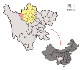
 Localisation du xian de Zamtang (en rose) dans la préfecture d'Aba (en jaune) | |
| Administration | |
|---|---|
| Pays | |
| Province ou région autonome | Sichuan |
| Préfecture | Aba |
| Statut administratif | Xian |
| Code postal | 624300[1] |
| Indicatif | +86 (0) |
| Démographie | |
| 31 567 hab. (1999) | |
| Densité | 4,8 hab./km2 |
| Géographie | |
| Coordonnées | 32° 15′ 56″ nord, 100° 58′ 44″ est |
| Superficie | 664 022 ha = 6 640,22 km2 |
| Localisation | |
 Localisation dans la préfecture de Aba. | |
| Liens | |
| Site web | www.rangtang.gov.cn |
| modifier |
|
Le xian de Zamtang (chinois : 壤塘县 ; pinyin : ; tibétain : ཛམ་ཐང་རྫོང, Wylie : dzam thang rdzong, pinyin tibétain : Camtang Zong, THL : Dzamthang) est un district administratif de la province du Sichuan en Chine. Il est placé sous la juridiction de la préfecture autonome tibétaine et qiang d'Aba.
Histoire
[modifier | modifier le code]Fuite des Jonang pendant l'oppression par le dalaï-lama en 1642
[modifier | modifier le code]Les survivants Jonangs des massacres par Lobsang Gyatso, le 5e dalaï-lama et leurs alliés mongols qoshots guidés par Güshi Khan en 1642 fuirent dans le xian de Zamtang (ou Dzamthang). Les Gélugpa considéraient la vision des jonangs du Zhentong de la vacuité, comme hérétique. Ils scellèrent les bibliothèques Jonangs et brûlèrent leur livres, ils furent persécutés et leurs monastères annexés. Il a tout de même subsisté le monastère de Tsangwa, situé à Dzamthang[2].
Démographie
[modifier | modifier le code]La population du district était de 31 567 habitants en 1999[3].
Notes et références
[modifier | modifier le code]- (en) Codes postaux et téléphoniques du Sichuan, (en) China Zip Code/ Telephone Code, ChinaTravel.
- (en) Michael Sheehy et Rudy Harderwijk, « History of the Jonang Tradition », sur International Kalachakra Network
- (en) National Population Statistics Materials by County and City - 1999 Period, in « China County & City Population 1999 », sur Harvard China Historical GIS (version du sur Internet Archive)
Voir aussi
[modifier | modifier le code]Bibliographie
[modifier | modifier le code]- Andreas Gruschke: The Cultural Monuments of Tibet’s Outer Provinces: Amdo - Volume 2. The Gansu and Sichuan Parts of Amdo, White Lotus Press, Bangkok 2001.
- Tsering Shakya: The Dragon in the Land of Snows. A History of Modern Tibet Since 1947, London 1999, (ISBN 0-14-019615-3)
Liens externes
[modifier | modifier le code]- (zh) Site gouvernemental
- (zh) Page descriptive


