Clare, Iowa
Appearance
Clare, Iowa | |
|---|---|
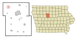
 Location of Clare, Iowa | |
| Coordinates: 42°35′16″N 94°20′37″W / 42.58778°N 94.34361°W | |
| Country | |
| State | |
| County | Webster |
| Incorporated | 1882 |
| Area | |
| • Total | 0.50 sq mi (1.28 km2) |
| • Land | 0.50 sq mi (1.28 km2) |
| • Water | 0.00 sq mi (0.00 km2) |
| Elevation | 1,155 ft (352 m) |
| Population | |
| • Total | 136 |
| • Density | 274.19/sq mi (105.92/km2) |
| Time zone | UTC-6 (CST) |
| • Summer (DST) | UTC-5 (CDT) |
| ZIP code | 50524 |
| Area code | 515 |
| FIPS code | 19-13485 |
| GNIS feature ID | 0455422 |
Clare is a city in Iowa in the United States.
References
- ↑ "2020 U.S. Gazetteer Files". United States Census Bureau. Retrieved March 16, 2022.
- ↑ "Clare city, Iowa". United States Census Bureau. Retrieved November 4, 2023.
