 Yahoo奇摩新聞
吳德榮
- 三立新聞網 setn.com • 2 小時前
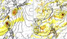
準氣象/準山陀兒離台越近「環流也越強」!吳德榮示警:直逼強颱
今(27)日衛星雲圖顯示,台灣周遭仍有些雲層環繞,因此容易在午後被對流激發,尤其是北台灣基隆一帶對流發展就相當強,時雨量還有達到50毫米左右,因此容易造成短暫淹水的現象,其餘地方則較微弱,雖然降雨範圍看似很大,但整體程度都沒有很強。
- 新頭殼 • 1 天前
燕子颱風恐穿台!「這天」最靠近 吳德榮示警:威脅大
[Newtalk新聞] 中央氣象���今(26)日指出,台灣東南方有熱帶擾動發展,有機會增強為颱風「燕子」。氣象專家吳德榮指出,根據美國模式預測,燕子颱風恐直接穿過台灣,下週一(30日)至週三最靠近台灣。吳德榮也示警「離台灣最近時的強度,恐怕達到中度颱風以上,對台灣威脅大」。 今、明兩日熱帶擾動逐漸會成形,週末就會成為熱帶性低氣壓或颱風,並且往台灣東南海域靠近。吳德榮表示,歐洲模式預測燕子颱風將往東北部移動,而美國模式預測路徑更接近,甚至可能直接穿過...
- 三立新聞網 setn.com • 2 天前
準氣象/熱帶擾動恐變「中度以上颱風」 吳德榮:這時間可能通過台灣
低壓帶減弱!三立氣象主播吳德榮指出,今(25)日北台灣清晨有雨,下午仍有雲層發展,不過今日對流較弱,僅午後山區有雨。氣溫方面,全台高溫在34度至35度,氣溫較為悶熱。另外,吳德榮指出下週一(30日)至下週三(2日)可能會有颱風���成。
- 三立新聞網 setn.com • 1 天前
準氣象/下週輕颱機率達100%!4成機率變中颱 吳德榮曝對台影響
颱風「燕子」最快明日生成,「山陀兒」也緊隨其後預計週末誕生,氣象署預估前者對台灣無影響,但「山陀兒」路徑仍有不確定性,且不排除有登陸台灣的可能性。
- 三立新聞網 setn.com • 3 天前
準氣象/雨區才剛變小…明晚又有鋒面來襲!午後雷雨連炸4天
天氣持續不穩定!三立氣象主播吳德榮指出,今(24)日的降雨範圍比前兩天小,明(25)日的天氣也和今日類似,值得注意的是,明晚將有鋒面接近台灣,它到達台灣上空後雖然會減弱,但仍將持續影響天氣,造成連日大氣不穩,每天下午易有強降雨,到了週六(28日)鋒面依舊會影響台灣天氣。
- 三立新聞網 setn.com • 2024年9月20日 晚上 09:20
準氣象/熱帶低壓會成颱?吳德榮給「1答案」 週末雨彈炸全台
留意週末天氣!三立氣象主播吳德榮指出,今(20)日有熱帶性低氣壓生成,發展成颱風的機會雖不高,但仍可能會影響到台灣的天氣,造成明(21)日北台灣的雨持續下到晚上。另外,位在台灣南方的低壓雨帶逐漸逼近,預估在週日(22日)就會籠罩全台,要注意局部性大雨等劇烈天氣。雨帶預計週二(24日)就會北抬,但台灣的天氣依舊不穩定。
- 鏡週刊Mirror Media • 2024年9月18日 上午 09:46
颱風蘇力將成形「不會侵台」 吳德榮:將讓台灣進入多雨環境
近日颱風接連成形,氣象專家吳德榮今(18日)日在「三立準氣象.老大洩天機」專欄表示,南海一熱帶低壓今將發展為第15號輕颱「蘇力」,雖然預測不會侵台,但水氣的增加將使台灣逐漸進入多雨的環境,需持續關注天氣變化。
- 太報 • 2024年9月20日 早上 08:32
低壓環流北移 今起5天防「劇烈天氣」
中央氣象局表示,今(9/20)起全台進入多雨天氣,今天環境風場偏南風,受南方雲系北移影響,天氣不穩定,明天起到下週二全台陷入濕濕的天氣,週日南部更可能出現局部豪雨;氣象專家吳德榮指出,由於大「季風低壓環流」北移,將帶來劇烈天氣,應隨時注意最新資料。
- 中天新聞網 • 2024年9月20日 早上 07:16
季風低壓通過…天氣極度不穩! 吳德榮警示:今起連五天恐炸雨
近日天氣不穩定,午後時不時會有強降雨,氣象專家吳德榮今(20日)表示,由於季風低壓通過,未來五天將出現大雷雨及劇烈天氣威脅,呼籲大家留意。
- 三立新聞網 setn.com • 2024年9月20日 早上 06:55
3縣市豪雨特報!季風低壓環流通過 吳德榮示警全台連5天炸雨防劇烈天氣
生活中心/施郁韻報導 中央氣象署針對3縣市發布豪雨特報,南方雲系北移及對流雲系發展旺盛,易有短延時強降雨,今(20)日屏東縣有局部大雨或豪雨,高雄及台東地區有局部大雨
- 三立新聞網 setn.com • 2024年9月19日 晚上 11:55
準氣象/明起天氣極不穩!雨彈連炸4天 「這2天」雨最強
三立準氣象/倪譽瑋報導雨下不停!三立氣象主播吳德榮指出,雖然目前蘇力、葡萄桑颱風對台灣沒有影響,但颱風離開後,季風低壓將會逐漸接近台灣,從明(20)日起南部便會迎接水氣,隨著季風低
- 中央社 • 2024年9月17日 上午 10:53
吳德榮:中秋台灣東側水氣多 西半部多雲時晴 (圖)
氣象專家吳德榮表示,最新歐洲模式模擬顯示,17日中秋節台灣東側水氣多,大台北、東半部雲量多、偶有局部短暫雨;西半部多雲時晴、午後山區偶有局部短暫陣雨。圖為台北市松山區上午天氣晴朗,民眾撐傘防曬。
- 三立新聞網 setn.com • 2024年9月19日 早上 07:00
蘇力颱風最快今生成!吳德榮示警「連5天全台炸雨」時間曝 防劇烈天氣
生活中心/施郁韻報導 氣象專家吳德榮指出,今(19)日2時中央氣象署「路徑潛勢預測圖」顯示,第14號輕颱「葡萄桑」向西北西、已進入東海,下午起侵襲浙江北部。另一熱帶低
- 三立新聞網 setn.com • 2024年9月18日 晚上 10:15
準氣象/台灣受雙颱影響?「這天」起雨越下越猛 放晴時間點曝光
三立準氣象/魏君程報導 受颱風外圍水氣影響,三立氣象主播吳德榮指出,今(18)日東部、北部地區有雨,中南部山區、部分平地下午開始有小範圍對流發展,帶來較強降雨。氣溫方
- 三立新聞網 setn.com • 2024年9月18日 凌晨 05:55
蘇力颱風恐今生成!最新路徑曝光 吳德榮示警這天起「大雷雨連炸5天」
生活中心/施郁韻報導 氣象專家吳德榮指出,今(18)日2時中央氣象署「路徑潛勢預測圖」顯示,第14號輕颱「葡萄桑」向西北西朝琉球前進,經東海撲向浙江。另一熱帶低壓在南
- 三立新聞網 setn.com • 2024年9月17日 早上 06:05
5縣市豪大雨!「蘇力估今生成」恐3颱共舞 吳德榮揭侵台機率
生活中心/林昀萱報導 中央氣象署發布5縣市豪雨特報,今(17)日花蓮縣及臺東縣有局部大雨或豪雨,高雄、屏東地區、蘭嶼、綠島及宜蘭山區有局部大雨發生的機率。
- 三立新聞網 setn.com • 2024年9月16日 早上 06:55
中秋東雨西晴!吳德榮揭葡萄桑「偏南」路徑 還有1熱帶擾動更需注意
生活中心/林昀萱報導中央氣象署發布4縣市高溫資訊,今(16)日中午前後臺東縣為橙色燈號,有連續出現36度高溫的機率,請加強注意。臺北市、新北市、桃園市為黃色燈號,請注意。今日白天臺
- 三立新聞網 setn.com • 2024年9月16日 晚上 07:55
準氣象/蘇力估明生成「雙颱環繞台灣」!吳德榮揭對台影響
三立準氣象/黃依婷報導 今(16)日衛星雲圖顯示,台灣東邊雲系逐漸增多,但上半天天氣仍屬晴朗,因此整體氣溫仍舊偏高,目前為止雖然降雨較不明顯,不過降雨機率將會逐漸提高
- 三立新聞網 setn.com • 2024年9月15日 早上 06:25
貝碧佳增強轉中颱!路徑曝光 今1地區午後炸大雨!吳德榮揭中秋節天氣
生活中心/施郁韻報導 氣象專家吳德榮表示,今(15)日2時中央氣象署路徑潛勢預測圖顯示,第13號中颱「貝碧佳」已進入東海,撲向長江口,今晚至明日對長江三角洲構成嚴重威
- 中時新聞網 • 2024年9月15日 早上 08:16
貝碧佳轉中颱 多個擾動發展!中秋賞月天氣曝
貝碧佳颱風目前位於台北東北方790公里海面上,向西北西轉西前進,氣象署表示,貝碧佳今天凌晨2時增強為中度颱風,今天與台灣距離相對較近,雖然沒有直接影響,但今、明兩天要注意長浪。氣象專家吳德榮表示,今、明天晴時多雲,至於中秋賞月機率,明晚至周二中秋節大台北、東半部偶有雨,西半部多雲時晴,周三大季風環流內有多個擾動發展,是否增強成熱帶性低氣壓或颱風,要再觀察。
- 三立新聞網 setn.com • 2024年9月14日 早上 07:30
老大洩天機/貝碧佳將轉中颱最新路徑曝 「中秋節天氣」吳德榮解答了
文/吳德榮 三立準氣象‧老大洩天機 今(14)日2時中央氣象署「路徑潛勢預測圖顯示,第13號輕颱「貝碧佳」續朝琉球前進、明(15日)進入東海,以中颱之姿、撲向長江口,對
- 中央社 • 2024年9月9日 下午 03:49
吳德榮:未來一週各地多短暫陣雨 (圖)
氣象專家吳德榮9日表示,未來一週天氣不穩定,有多個低氣壓、擾動存在;9日至11日台灣東北方有低壓接近、通過,各地有短暫陣雨;14、15日可能有另一個低壓接近,待持續觀察。圖為民眾自碧山巖眺望台北市。中央社記者王飛華攝 113年9月9日
- 三立新聞網 setn.com • 2024年9月13日 晚上 09:00
準氣象/下週估又有「2熱帶擾動」生成!是否影響中秋吳德榮解答了
三立準氣象/黃依婷報導 今日衛星雲圖顯示,颱風「貝碧佳」目前仍在日本南方海面,並持續往琉球方向前進,且也有部分雲層往台灣前進,東半部也因此受到影響出現降雨,不過大部分
- 三立新聞網 setn.com • 2024年9月9日 晚上 09:55
準氣象/歐洲模式估中秋節「颱風環流」現蹤台灣周遭!吳德榮示警2地區
三立準氣象/黃依婷報導今(9)日衛星雲圖顯示,低壓雲系不斷接近台灣,不過尚未有實際影響,主要降雨出現在午後的新竹以南有強對流胞發展,其中以嘉義、台南一帶最為劇烈,氣象署對此也發布大
- 鏡週刊Mirror Media • 2024年9月10日 早上 06:50
「貝碧佳」最快明成颱!全台有雨「中南部防午後雷雨」 吳德榮示警了
中央氣象署指出,今日低氣壓影響,北部及東北部地區有局部短暫陣雨,並有局部較大雨勢發生的機率,東部及東南部地區亦有零星短暫陣雨,其他地區為多雲,午後中南部地區及各地山區有局部短暫雷陣雨。此外,第13號颱風「貝碧佳」最快明天生成,週五到下週一台灣北側水氣增多。
- 三立新聞網 setn.com • 2024年9月8日 早上 06:50
今起雨彈恐炸7天警戒區曝!吳德榮示警:下週低壓通過變天 擾動醞釀中
生活中心/施郁韻報導氣象專家吳德榮指出,今(8)日凌晨2時中央氣象署「路徑潛勢預測圖」顯示,第11號輕颱「摩羯」在越南北部,向西北西,下午減弱為熱帶低壓。最新歐洲模式模擬顯示,週二
- 鏡週刊Mirror Media • 2024年9月8日 早上 07:39
低壓接近 全台天氣轉不穩定!吳德榮:關島有擾動醞釀中
中央氣象署指出,今日受低壓帶影響,水氣偏多,各地及澎湖、金門、馬祖有局部短暫陣雨或雷雨,並有局部大雨發生的機率。氣象專家吳德榮也指出,本週水氣多、易降雨,至於關島附近有擾動醞釀中。
- 三立新聞網 setn.com • 2024年9月11日 凌晨 05:35
颱風貝碧佳生成!明起「大雷雨狂炸3天」半個台灣濕答答 吳德榮示警了
生活中心/張家寧報導 氣象專家吳德榮表示,今(11)日2時中央氣象署「路徑潛勢預測圖顯示,TD15向西北、朝浙江前進,對台無影響;第12號輕颱「貝碧佳」昨晚生成,預測
- 三立新聞網 setn.com • 2024年9月10日 早上 06:00
低壓籠罩變天!「北台雨彈狂灌」全台警戒區曝光 吳德榮示警了
生活中心/張家寧報導 氣象專家吳德榮表示,最新歐洲模式未來10天的模擬顯示,台、菲東方及日本南方海面的大低壓環流內、有多個低壓擾動存在。今(10)日20時模擬顯示,低
- 三立新聞網 setn.com • 2024年9月14日 凌晨 05:50
今全台濕答答!「午後大雷雨狂灌」警戒區曝 吳德榮示警了
生活中心/張家寧報導 氣象專家吳德榮表示,今(14)日2時中央氣象署「路徑潛勢預測圖顯示,第13號輕颱「貝碧佳」續朝琉球前進、明進入東海,以中颱之姿、撲向長江口,對台