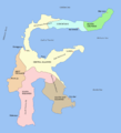
Payl:Sulawesi map.PNG
Appearance

Gidak-on ning maong paunang tan-aw: 543 x 599 ka mga piksel. Uban pang mga resoluyon: 217 x 240 ka mga piksel | 435 x 480 ka mga piksel | 696 x 768 ka mga piksel | 928 x 1,024 ka mga piksel | 1,492 x 1,647 ka mga piksel.
Tibuok resolusyon (1,492 × 1,647 pixels, size sa payl: 83 KB, MIME type: image/png)
Kaagi sa payl
I-klik ang petsa/oras aron makit-an ang hulagway sa payl niadtong panahona.
| Petsa/Takna | Thumbnail | Mga dimensyon | Tiggamit | Komento | |
|---|---|---|---|---|---|
| kasamtangan | 12:11, 11 Marso 2006 |  | 1,492 × 1,647 (83 KB) | Roke~commonswiki | fixed borders of provinces |
| 04:55, 11 Marso 2006 |  | 1,492 × 1,647 (82 KB) | Roke~commonswiki | Sulawesi showing provinces, their capital cities, a few other cities and some surrounding areas of water. Note that there are other islands in this area which are not shown as this is a map of Sulawesi island itself. Category:Sulawesi [[Category:Maps |
Mga paggamit sa payl
Ang mosunod nga 3 panid misumpay niining payl:
Global nga paggamit sa payl
Kining ubang wiki naggamit ning maong payl:
- Paggamit sa af.wikipedia.org
- Paggamit sa bg.wikipedia.org
- Paggamit sa bn.wikipedia.org
- Paggamit sa bug.wikipedia.org
- Paggamit sa ca.wikipedia.org
- Paggamit sa cs.wikipedia.org
- Paggamit sa cy.wikipedia.org
- Paggamit sa el.wikipedia.org
- Paggamit sa en.wikipedia.org
- Paggamit sa es.wikipedia.org
- Paggamit sa eu.wikipedia.org
- Paggamit sa fa.wikipedia.org
- Paggamit sa fi.wikipedia.org
- Paggamit sa fr.wikipedia.org
- Paggamit sa ga.wikipedia.org
- Paggamit sa gl.wikipedia.org
- Paggamit sa gl.wiktionary.org
- Paggamit sa hi.wikipedia.org
- Paggamit sa hu.wikipedia.org
- Paggamit sa id.wiktionary.org
- Paggamit sa ilo.wikipedia.org
- Paggamit sa is.wikipedia.org
- Paggamit sa it.wikipedia.org
- Paggamit sa ja.wikipedia.org
- Paggamit sa kk.wikipedia.org
- Paggamit sa km.wikipedia.org
- Paggamit sa la.wikipedia.org
- Paggamit sa map-bms.wikipedia.org
- Paggamit sa mi.wikipedia.org
- Paggamit sa ml.wikipedia.org
- Paggamit sa mrj.wikipedia.org
- Paggamit sa mr.wikipedia.org
- Paggamit sa ms.wikipedia.org
View more global usage of this file.

