''Megalopolis'' is a Western deformation of the Greek word that derived from {{lang-gr|μέγας}} - 'great' and {{lang-gr|πόλις}} - 'city', therefore literally a 'great city'. This term is closer in meaning to ''[[megacity]]''. Because in Greek, πόλις is feminine, the correct term is '''megalopolis'''.
''Megalopolis'' is a Western deformation of the Greek word that derived from {{lang-gr|μέγας}} - 'great' and {{lang-gr|πόλις}} - 'city', therefore literally a 'great city'. This term is closer in meaning to ''[[megacity]]''. Because in Greek, πόλις is feminine, the correct term is '''megalopolis'''.
Modern interlinked ground [[transportation corridors]], such as rail and highway, often aid in the development of megalopolises. Using these commuter passageways to travel throughout the megalopolis is informally called ''megaloping''. This term was coined by Davide Gadren and Stefan Berteau.<ref>{{cite web |url=http://www.citypaper.net/articles/2007/05/31/fumbling-toward-portland |title=Fumbling Toward Portland |last=Tremble |first=Sam |date=May 30, 2007 |work=Philadelphia City Paper}}</ref>
Modern interlinked ground [[transportation corridors]], such as rail and highway, often aid in the development of megalopolises. Using these commuter passageways to travel throughout the megalopolis is informally called ''megaloping''. This term was coined by Davide Gadren and Stefan Berteau.<ref>{{cite web |url=http://www.citypaper.net/articles/2007/05/31/fumbling-toward-portland |title=Fumbling Toward Portland |last=Tremble |first=Sam |date=May 30, 2007 |work=Philadelphia City Paper}}</ref>
Line 16:
Line 16:
* [[Cairo]]–[[Giza]]–[[Qalyubia]]–[[Helwan]]–[[6th of October City]] ([[Greater Cairo]]), Egypt (16 million) The area around the [[Nile]] is also very densely populated.
* [[Cairo]]–[[Giza]]–[[Qalyubia]]–[[Helwan]]–[[6th of October City]] ([[Greater Cairo]]), Egypt (16 million) The area around the [[Nile]] is also very densely populated.
* [[Nile River Delta]] Governorates (Alexandria, Beheira, Kafr el-Sheikh, Gharbia, Monufia, Qalyubia, Dakahlia, Damietta, Al Sharqia, and Port Said) have a combined population of 41,045,135. The total area of these Governorates is 18,199 square miles making the population density 2,255.4 per square mile.
* [[Nile River Delta]] Governorates (Alexandria, Beheira, Kafr el-Sheikh, Gharbia, Monufia, Qalyubia, Dakahlia, Damietta, Al Sharqia, and Port Said) have a combined population of 41,045,135. The total area of these Governorates is 18,199 square miles making the population density 2,255.4 per square mile.
* The [[Gauteng]] City Region ([[Pretoria-Witwatersrand-Vereeniging|PWV]]) in South Africa, which includes the urbanised portion of Gauteng Province ([[Pretoria]], [[Centurion, Gauteng|Centurion]], [[Midrand]], [[Johannesburg]] and the [[Vaal Triangle]], with a population of over 10 million)<ref>[http://www.joburg.org.za/2006/aug/aug30_globalcity.stm ]{{deadlink|date=April2017}}</ref><ref>[http://www.joburg.org.za/2006/july/jul20_cityregion.stm ]{{deadlink|date=April2017}}</ref><ref>{{cite web|url=http://www.info.gov.za/speeches/2006/06082311451004.htm |title=Welcome to the official South African government online site! | South African Government |website=Info.gov.za |date= |accessdate=2017-04-06}}</ref>
* The [[Gauteng]] City Region ([[Pretoria-Witwatersrand-Vereeniging|PWV]]) in South Africa, which includes the urbanised portion of Gauteng Province ([[Pretoria]], [[Centurion, Gauteng|Centurion]], [[Midrand]], [[Johannesburg]] and the [[Vaal Triangle]], with a population of over 10 million)<ref>http://www.joburg.org.za/2006/aug/aug30_globalcity.stm |= }}</ref><ref>http://www.joburg.org.za/2006/july/jul20_cityregion.stm |= }}</ref><ref>{{cite web|url=http://www.info.gov.za/speeches/2006/06082311451004.htm |title=Welcome to the official South African government online site! | South African Government |website=Info.gov.za |date= |accessdate=2017-04-06}}</ref>
*The region in Morocco including [[El Jadida]]-[[Casablanca]]-[[Rabat]]-[[Salé]]-[[Kenitra]], concentrating in the long coastal belt, on around 250 km with a depth of 40 to 50 km, more than 11 million inhabitants.{{Citation needed|date=January 2013}}
*The region in Morocco including [[El Jadida]]-[[Casablanca]]-[[Rabat]]-[[Salé]]-[[Kenitra]], concentrating in the long coastal belt, on around 250 km with a depth of 40 to 50 km, more than 11 million inhabitants.{{Citation needed|date=January 2013}}
* The [[Nairobi]] Metropolitan Region consisting of the counties of ([[Kajiado County|Kajiado]]-[[Kiambu County|Kiambu]]-[[Nairobi County|Nairobi]]-[[Machakos County|Machakos]]-[[Murang'a County|Murang'a]]) in Kenya, which have a combined population of 8 million people.<ref>{{cite web|author= |url=http://www.standardmedia.co.ke/thecounties/article/2000152596/cabinet-secretary-names-team-to-modernize-nairobi-city-transport |title=Cabinet Secretary names team to modernize Nairobi city transport :: Kenya - The Standard |website=Standardmedia.co.ke |date=2015-02-23 |accessdate=2017-04-06}}</ref>
* The [[Nairobi]] Metropolitan Region consisting of the counties of ([[Kajiado County|Kajiado]]-[[Kiambu County|Kiambu]]-[[Nairobi County|Nairobi]]-[[Machakos County|Machakos]]-[[Murang'a County|Murang'a]]) in Kenya, which have a combined population of 8 million people.<ref>{{cite web|author= |url=http://www.standardmedia.co.ke/thecounties/article/2000152596/cabinet-secretary-names-team-to-modernize-nairobi-city-transport |title=Cabinet Secretary names team to modernize Nairobi city transport :: Kenya - The Standard |website=Standardmedia.co.ke |date=2015-02-23 |accessdate=2017-04-06}}</ref>
Line 64:
Line 64:
# [[Dhaka]] (Greater Dhaka Megalopolis consists four city Corporations: [[Dhaka South City Corporation|Dhaka South]], [[Dhaka North City Corporation|Dhaka North]], [[Gazipur City|Gazipur]], and [[Narayanganj]] and five municipals: [[Savar Upazila]] (A class), [[Dohar Upazila]] (A class), [[Dhamrai Upazila]] (A class), [[Tongi]] (Special Class), [[Sonargaon]] (B class) [http://www.adb.org/sites/default/files/linked-documents/42169-013-ban-ssa.pdf (17,000,000)]
# [[Dhaka]] (Greater Dhaka Megalopolis consists four city Corporations: [[Dhaka South City Corporation|Dhaka South]], [[Dhaka North City Corporation|Dhaka North]], [[Gazipur City|Gazipur]], and [[Narayanganj]] and five municipals: [[Savar Upazila]] (A class), [[Dohar Upazila]] (A class), [[Dhamrai Upazila]] (A class), [[Tongi]] (Special Class), [[Sonargaon]] (B class) [http://www.adb.org/sites/default/files/linked-documents/42169-013-ban-ssa.pdf (17,000,000)]
| 110–130<ref>{{cite web|url=http://www.eu-partner.com/index.php?option=com_content&view=article&id=9:the-blue-banana&catid=1:news&Itemid=16|title=The European Blue Banana|author=Ina Schmidt|publisher=|accessdate=5 October 2014}}</ref>
| 110–130<ref>{{cite web|url=http://www.eu-partner.com/index.php?option=com_content&view=article&id=9:the-blue-banana&catid=1:news&Itemid=16|title=The European Blue Banana|author=Ina Schmidt|publisher=|accessdate=5 October 2014}}</ref>
A megalopolis (sometimes called a megapolis; also megaregion, or supercity)[1] is typically defined as a chain of roughly adjacent metropolitan areas. The term was used by Patrick Geddes in his 1915 book Cities in Evolution,[2] by Oswald Spengler in his 1918 book The Decline of the West, and Lewis Mumford in his 1938 book The Culture of Cities, which described it as the first stage in urban overdevelopment and social decline. Later, it was used by Jean Gottmann in his landmark 1961 study, Megalopolis: The Urbanized Northeastern Seaboard of the United States, to describe the chain of metropolitan areas along the northeastern seaboard of the U.S. extending from Boston, Massachusetts, through New York City, Philadelphia, Baltimore, and ending in Washington, D.C. and Northern Virginia.[3][4][5] The latter is sometimes called the "BosWashmegalopolis".
Definitions
Megalopolis is a Western deformation of the Greek word that derived from Greek: μέγας - 'great' and Greek: πόλις - 'city', therefore literally a 'great city'. This term is closer in meaning to megacity. Because in Greek, πόλις is feminine, the correct term is megalopolis.
A megalopolis, also known as a megaregion, is a clustered network of cities. Gottmann defined its population as 25 million.[6] Doxiadis defined a small megalopolis a similar cluster with a population of about 10 million.[7][8][9] America 2050,[10] a program of the Regional Plan Association, lists 11 megaregions in the United States and Canada.[7] Literally, megalopolis in Greek means a city of exaggerated size where the prefix megalo- represents a quantity of exaggerated size.[11]Megapolitan areas were explored in a July 2005 report by Robert E. Lang and Dawn Dhavale of the Metropolitan Institute at Virginia Tech.[12] A later 2007 article by Lang and Nelson uses 20 megapolitan areas grouped into 10 megaregions.[13] The concept is based on the original Megalopolis model.[9]
Modern interlinked ground transportation corridors, such as rail and highway, often aid in the development of megalopolises. Using these commuter passageways to travel throughout the megalopolis is informally called megaloping. This term was coined by Davide Gadren and Stefan Berteau.[14]
Nile River Delta Governorates (Alexandria, Beheira, Kafr el-Sheikh, Gharbia, Monufia, Qalyubia, Dakahlia, Damietta, Al Sharqia, and Port Said) have a combined population of 41,045,135. The total area of these Governorates is 18,199 square miles making the population density 2,255.4 per square mile.
The region in Morocco including El Jadida-Casablanca-Rabat-Salé-Kenitra, concentrating in the long coastal belt, on around 250 km with a depth of 40 to 50 km, more than 11 million inhabitants.[citation needed]
The central Liaoning city cluster in China. Within 150 km from its center Shenyang (7.2 million), it has Fushun (3 million), Anshan City (3.6 million), Benxi (1.5 million), Liaoyang (1.8 million), Yingkou (2.2 million), Panjin (1.2 million), and Tieling (3.4 million), with a total population of 23 million. And it can be further extended to Dalian (6.2 million), Fuxin (2 million) and Dandong (2.4 million). This area used to be the most industrialized region in China. It declined during 1980s-1990s, but in recent years, it has rapidly revived.
Greater Tehran: A region located in Iranian Tehran and Alborz Province in central Northern Iran with its influence expanding in Qom Province, Qazvin Province and Mazandaran Province, home for at least 15 million people, it is one of the most populous urban areas in the Greater Middle East and the surrounding regions. Tehran was a small village 200 years ago when it was first chosen as the Capital city and it has been growing at a very fast rate.
Turkey
(all figures extrapolated from end of 2014 and end of 2015 figures of,[30] to middle of year 2016)
Greater Istanbul: Includes Istanbul city proper, with continuous urbanization spilling over to neighboring provinces, as well as nearby dense population and highly industrialized areas. Istanbul, eastern counties of Tekirdağ province, entire coast of Izmit bay, and Adapazarı add up to 17.5 million population.
Constituent urban areas of each megalopolis are based on reckoning by a single American organization, the Regional Plan Association (RPA). The RPA definition of the Great Lakes Megalopolis includes some Canadian metropolitan areas with the United States, including some but not all major urban centres in the Windsor-Quebec City Corridor. Note that one city, Houston, is listed in two different Megalopolis regions as defined by the RPA, (the Gulf Coast and Texas Triangle).[7][42]
The following megaregions in Colombia are expected to have nearly 93% (55 Million people) of its population by 2030, up from the current 72%. There are currently 4 major megaregions in Colombia.
^"Archived copy". Archived from the original on 2006-10-07. Retrieved 2007-01-01. {{cite web}}: Unknown parameter |deadurl= ignored (|url-status= suggested) (help)CS1 maint: archived copy as title (link)
^"Archived copy". Archived from the original on 2006-09-24. Retrieved 2007-01-01. {{cite web}}: Unknown parameter |deadurl= ignored (|url-status= suggested) (help)CS1 maint: archived copy as title (link)
^"地域活性化戦略(案)資料"(PDF) (in Japanese). Ministry of Economy, Trade and Industry. p. 4. Retrieved August 13, 2016.
^"2015 Population Census". Statistics Bureau, Ministry of Internal Affairs and Communications. Retrieved August 13, 2016.
^A government publication states that on 1 November 2010, the population of "Seoul Metropolitan Area" stood at 23,616 thousand, which is the sum of the figures given for Gyeonggi-do (11,270 thousand), Seoul (9,708 thousand) and Incheon (2,638 thousand), apparently including the periphery. Source: "Preliminary Results of the 2010 Population and Housing Census" (PDF). Statistics Korea. 21 January 2011. Retrieved 23 July 2011.
^"Brookings". The Brookings Institution. 30 November 2012. Archived from the original on 6 January 2013. Retrieved 5 October 2014. {{cite web}}: Unknown parameter |deadurl= ignored (|url-status= suggested) (help)
^Ordóñez Burbano, Luis A. (2007). Universidad del Valle 60 años 1945-2005: Atando cabos en clave de memoria. Cali, Valle del Cauca, Colombia: Universidad del Valle. p. 58. OCLC645219600


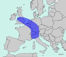 The Blue Banana
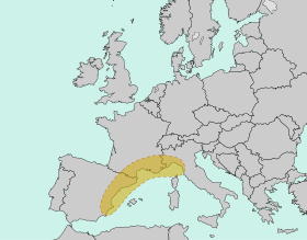 The Golden Banana
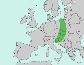 The Green Banana


.jpg)


