
Walensee
| Walensee | |
|---|---|
| Lake Walen Lake Walenstadt | |
 Walensee and Unterterzen, Quarten | |
 Walensee  Walensee  Walensee  Walensee | |
 Map | |
| Location | St. Gallen, Glarus |
| Coordinates | 47°7′N 9°12′E / 47.117°N 9.200°E |
| Primary inflows | Linth (Escherkanal), Seez, Murgbach |
| Primary outflows | Linth canal |
| Basin countries | Switzerland |
| Surface area | 24.19 km2 (9.34 sq mi) |
| Average depth | 104.7 m (344 ft) |
| Max. depth | 151 m (495 ft) |
| Water volume | 2.5 km3 (2,000,000 acre⋅ft) |
| Residence time | 1.45 years |
| Surface elevation | 419 m (1,375 ft) |
| Islands | Schnittlauchinsel |
| Settlements | Walenstadt, Weesen, Quinten, Quarten, Murg |
 | |
The Walensee (German pronunciation: [ˈvaːln̩ˌzeː] ), also known as Lake Walen or Lake Walenstadt, is one of the larger lakes in Switzerland, with about two thirds of its area in the canton of St. Gallen and about one third in the canton of Glarus.
Its name means 'Lake of the Walhaz' (German: See der Welschen), since in the early Middle Ages Lake Walen formed the linguistic border between the Alemanni, who settled in the west, and the Romansh people, the Walhaz (Welschen), in the east.[1]
Geography
[edit]Apart from Walenstadt at the eastern end of the lake, other lakeside towns and villages are Weesen and Quarten (including Murg, Quinten and Unterterzen). Quinten, located on the northern shore of the lake, can only be reached on foot or by boat as there are no roads. To the south, the lake is followed by the A3 motorway and the Ziegelbrücke–Sargans railway line.
The three main rivers leading to the lake are the Seez, Murgbach, and Linth. The latter continues its course from Walensee to Obersee (Lake Zurich) through the Linth canal. Until the regulation of the Linth during the early 19th century, the river bypassed Walensee west of the lake. The Seerenbach Falls and Rinquelle are adjacent to the lake. The Schnittlauchinsel, at the eastern end of the lake, is the only island in the Walensee.
The Churfirsten range raises steeply on the north side from the lake's level at 419 m (1,375 ft) to 2,306 m (7,566 ft) above sea level, joining the Mattstock (1,936 m (6,352 ft)) and Federispitz (1,865 m (6,119 ft)) to the west. On the south, the lake is overlooked by the Mürtschenstock Massif, whose peak is 2,441 m (8,009 ft) above sea level. The resort area Flumserberg overlooks the lake. The highest point of the lake's drainage basin is the Tödi (3,614 m (11,857 ft)).[2]

Arts
[edit]The lake provided the inspiration for a solo piano piece by Hungarian Romantic composer Franz Liszt, Au lac de Wallenstadt. The piece is part of a collection of solo piano works inspired by his travels to Switzerland in the 1830s.
Gallery
[edit]-
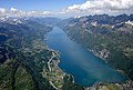 Aerial image of the Walensee
 -
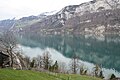 Looking to the west towards Amden


See also
[edit]References
[edit]External links
[edit] Media related to Walensee at Wikimedia Commons
- Waterlevels of Walensee at Murg
- Coolidge, William Augustus Brevoort (1911). . Encyclopædia Britannica. Vol. 28 (11th ed.). p. 258.
Lakes of Switzerland | ||
|---|---|---|
| Major lakes |
|  |
| Lists | ||
| International | |
|---|---|
| National | |
| Other | |
This Canton of St. Gallen location article is a stub. You can help Wikipedia by expanding it. |
This Canton of Glarus location article is a stub. You can help Wikipedia by expanding it. |