File:Barents sea map blank.png
Jump to navigation
Jump to search

Size of this preview: 655 × 599 pixels. Other resolutions: 262 × 240 pixels | 525 × 480 pixels | 839 × 768 pixels | 1,200 × 1,098 pixels.
Original file (1,200 × 1,098 pixels, file size: 252 KB, MIME type: image/png)
Captions
Captions
Add a one-line explanation of what this file represents

|
This locator map image could be re-created using vector graphics as an SVG file. This has several advantages; see Commons:Media for cleanup for more information. If an SVG form of this image is available, please upload it and afterwards replace this template with
{{vector version available|new image name}}.
It is recommended to name the SVG file “Barents sea map blank.svg”—then the template Vector version available (or Vva) does not need the new image name parameter. |
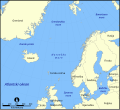
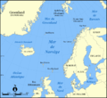
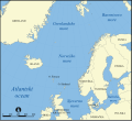
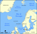
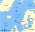
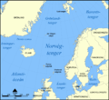
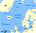
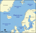
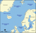
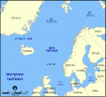
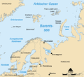
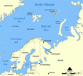
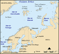
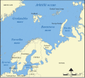
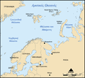
This map shows the location of the Barents Sea north of Russia and Norway, and the surrounding seas and islands.
Created by NormanEinstein, November 25, 2005.
Modified and blanked by historicair 22:27, 28 February 2006 (UTC)
I, the copyright holder of this work, hereby publish it under the following licenses:

|
Permission is granted to copy, distribute and/or modify this document under the terms of the GNU Free Documentation License, Version 1.2 or any later version published by the Free Software Foundation; with no Invariant Sections, no Front-Cover Texts, and no Back-Cover Texts. A copy of the license is included in the section entitled GNU Free Documentation License. |
| This file is licensed under the Creative Commons Attribution-Share Alike 3.0 Unported license. | ||
| ||
| This licensing tag was added to this file as part of the GFDL licensing update. |
You may select the license of your choice.
derivative works
[edit][]
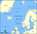
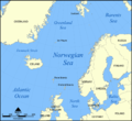
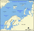
- Norwegian Sea
-

-
 bosanski
 -
 čeština
 -
 dansk
dansk -
 Deutsch
 -
 eesti
eesti -
 English
 -
 français
 -
 français (Jan Mayen localisation)
 -
 hrvatski
 -
 italiano
 -
 magyar
 -
 magyar
 -
 norsk
norsk -
 svenska
 -
 македонски
 -
 нохчийн
 -
 русский
 -
 українська
 -
 中文
中文 -
 עברית
עברית


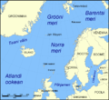
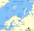
- Barents Sea
-

-
 Deutsch
 -
 English
 -
 español
 -
 hrvatski
 -
 magyar
 -
 Kiswahili
 -
 русский
 -
 Ελληνικά


File history
Click on a date/time to view the file as it appeared at that time.
| Date/Time | Thumbnail | Dimensions | User | Comment | |
|---|---|---|---|---|---|
| current | 22:27, 28 February 2006 | | 1,200 × 1,098 (252 KB) | Historicair (talk | contribs) | This map shows the location of the Barents Sea north of Russia and Norway, and the surrounding seas and islands. Created by NormanEinstein, November 25, 2005. Modified and blanked by ~~~~ {{GFDL-self}} Category:Maps of seas |
You cannot overwrite this file.
File usage on Commons
The following 30 pages use this file:
- File:Bahari ya Barents.png
- File:Barents Sea map.png
- File:Barents Sea map GR.png
- File:Barents Sea map hr.svg
- File:Barents Sea map hu.svg
- File:Barents Sea map ru.svg
- File:Barents sea map blank.png
- File:Barents sea map de.png
- File:Barents sp.png
- File:Carte de la mer de Norvège-Jan-Mayen-localisation.png
- File:Carte de la mer de Norvège.png
- File:Karte Europäisches Nordmeer.png
- File:Norra meri.png
- File:Norveško more.svg
- File:Norvég-tenger térkép 2.png
- File:Norvég tenger térkép.png
- File:Norwegian Sea blank map.png
- File:Norwegian Sea map-da.png
- File:Norwegian Sea map.png
- File:Norwegian Sea map ce.svg
- File:Norwegian Sea map ch.png
- File:Norwegian Sea map cs.png
- File:Norwegian Sea map it.png
- File:Norwegian Sea map mk.svg
- File:Norwegian Sea map no.png
- File:Norwegian Sea map ru.svg
- File:Norwegian Sea map sv.png
- File:Norwegian Sea map uk.svg
- Template:Other versions/Norwegian Sea
- Category:Barents Sea