Trimingham
Jump to navigation
Jump to search
See also Trimingham on Wikipedia
Dansk: Trimingham er en landsby i det Nord Norfolk
Deutsch: Trimingham ist eine Kleinstadt an der Nordseeküste von Norfolk in England im Distrikt North Norfolk
English: Trimingham is a village and civil parish in the North Norfolk district of Norfolk, England.
Español: Trimingham es un pueblo y una parroquia civil del distrito de North Norfolk, en el Inglaterra de Norfolk Inglaterra
Français : Trimingham est un village du comté de Norfolk en Angleterre
Parish location


Buildings
Religious buildings
Saint-John the-Baptist's head (Exterior)
Português: Igreja Cabeça de São João Batista.


.JPG)
.JPG)


Saint-John the-Baptist's head (Interior)


Primitive Methodist chapel (Former)

Other buildings and structures
Trimingham village hall


.JPG)
.JPG)
.JPG)
.JPG)

.JPG)
.JPG)
Pilgrim's Shelter
English: The vicar of the parish church in Trimingham, the Reverend Page, along with his gardeners, built the Pilgrim Shelter in 1935. It was to be used as a social club for the men of the village and once completed had a full-sized billiard table and dart board. In recent times the building has been used as Trimingham’s village hall until the completion of a new hall in 2018.


.JPG)


.JPG)
English: See:Category:Pilgrim's Shelter, Trimingham
Old school house


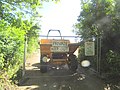
RAF Trimingham (Radome)


.JPG)

English: See:Category:RAF Trimingham
Lost buildings in Trimingham
-
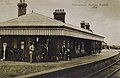 Trimingham Railway Station
 -
 Crown & Anchor Hotel
 -

.jpg)
.jpg)

Transport
Streets in Trimingham
Blackberry Hall Lane

.JPG)
.JPG)
English: See:Category:Blackberry Hall Lane, Trimingham
Beacon Road
English: See:Category:Beacon Road, Trimingham
Broadwood Close


.JPG)
.JPG)

.JPG)
English: See:Category:Broadwood Close, Trimingham
Church Street
-

-
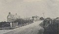
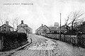 Church street in 1909
 -
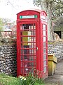 Defibrillator in an old red Telephone Box
 -

-


.JPG)
.JPG)
English: See:Category:Church Street, Trimingham
Church Road

.JPG)


English: See:Category:Church Road, Trimingham
Cromer Road


English: See:Category:Cromer Road, Trimingham
Heath Lane

.JPG)


English: See:Category:Heath Lane, Trimingham
Loop Road
-

-

-

-
 Road closed due to cliff erosion
 -
 Road closed due to cliff erosion
 -


.JPG)


English: See:Category:Loop Road, Trimingham
Middle Street


.JPG)
.JPG)


.JPG)

English: See:Category:Middle Street, Trimingham
Mundesley Road
-

-

-

-

-
 1911
1911 -

-
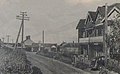
 1936
1936 -
 1936
1936


.JPG)


English: See:Category:Mundesley Road, Trimingham
Staden Park
.JPG)


.JPG)
English: See:Category:Staden Park, Trimingham
Railways
Trimingham Railway Station (Closed)
English: Trimingham railway station closed in 1953. It was a station in on the Norfolk and Suffolk Joint Railway line between Cromer Beach and North Walsham. It was located on what is now a housing development called Staden Park.


English: see:Category:Trimingham railway station
Railway Bridges
-
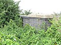 A disused, buried and overgrown former Norfolk and Suffolk Joint railway bridge
 -
A disused Norfolk and Suffolk Joint railway bridge
-
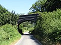 Trimingham road disused Norfolk and Suffolk Joint railway bridge
 -

.JPG)


Ships and Boats
Fishing boats
_(2).JPG)
English: see:Category:Fishing boats in Trimingham
Tourism
Caravan and Camping
Trimingham House Caravan Park

.JPG)
.JPG)
.JPG)
.JPG)
Woodland Holiday Park

.JPG)
.JPG)
.JPG)
.JPG)
Geography
Trimingham beach
-

-

-

-
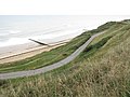 Road down to the beach
 -

-

-

-

.JPG)
.JPG)

.JPG)
.JPG)

.JPG)
.JPG)
Trimingham cliffs


.JPG)
.JPG)
.JPG)
.JPG)

Beacon Hill
-

-
-

-

-

-

-
1911
.JPG)

.JPG)
Trimingham gravel quarry


Pond Plantation
-

-

-
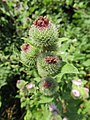 Chalk Knapweed
 -

-

-
 Sea Bindweed
 -
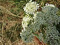 Meadowsweet
.JPG)
.JPG)
,_Trimingham_(1).JPG)
.jpg)
.JPG)
,_Trimingham.jpg)
,_Trimingham.JPG)