The Scottish Islands Portal
Welcome! — Fàilte! — Walcome!
-
-

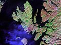
 Looking from the Isle of Mull towards Ardnamurchan peninsula as the Caledonian MacBrayne ferry MV Clansman sails past the Rubha nan Gall lighthouse
 -
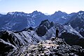
 The Cuillin, Isle of Skye
 -
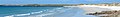
 Seilebost on Harris
 -
-
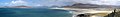
 View from Elgol on the Isle of Skye across to the Cuillin
 -
 Tombolo connecting St Ninian's Isle to Mainland, Shetland
 -

-
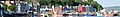
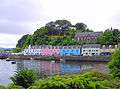
 Portree Waterfront, Isle of Skye


Scotland has around 900 offshore islands, most of which are to be found in four main groups: Shetland, Orkney, and the Hebrides, sub-divided into the Inner Hebrides and Outer Hebrides. There are also clusters of islands in the Firth of Clyde, Firth of Forth, and Solway Firth, and numerous small islands within the many bodies of fresh water in Scotland including Loch Lomond and Loch Maree. The largest island is Lewis and Harris which extends to 2,179 square kilometres, and there are a further 200 islands which are greater than 40 hectares in area. Of the remainder, several such as Staffa and the Flannan Isles are well known despite their small size. Some 94 Scottish islands are permanently inhabited, of which 89 are offshore islands. Between 2001 and 2011 Scottish island populations as a whole grew by 4% to 103,702.
The geology and geomorphology of the islands is varied. Some, such as Skye and Mull, are mountainous, while others like Tiree and Sanday are relatively low lying. Many have bedrock made from ancient Archaean Lewisian Gneiss which was formed 3 billion years ago; Shapinsay and other Orkney islands are formed from Old Red Sandstone, which is 400 million years old; and others such as Rùm from more recent Tertiary volcanoes. Many of the islands are swept by strong tides, and the Corryvreckan tide race between Scarba and Jura is one of the largest whirlpools in the world. Other strong tides are to be found in the Pentland Firth between mainland Scotland and Orkney, and another example is the "Grey Dog" between Scarba and Lunga. (More on Scottish islands...)
Selected picture
-
-

-
-
 White-tailed eagle fishing off Mull, one of several islands to which the birds have been successfully re-introduced
Credit: Jacob Spinks
-

-

-
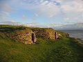
 The 1st-century Dun Carloway on Lewis is a well-preserved example of an Iron Age broch, a type of complex Atlantic roundhouse only found in Scotland
Credit: Morris R. Maciver
-
-
 Shetland mouse-ear, a rare plant species unique to Shetland and found only on two serpentine hills in the Keen of Hamar reserve on the island of Unst
Credit: Melvin Grey
-
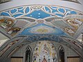 The Italian Chapel on Lamb Holm, Orkney was built from two Nissen huts by Italian prisoners of war during World War 2; the interior frescoes are by Domenico Chiocchetti
Credit: Renata
-
 The Neolithic farmstead of Knap of Howar on Papa Westray, Orkney, dates from 3700 BC and might be the oldest surviving stone dwelling in northern Europe
Credit: Me677
-

-

-
 The ferry from Glenelg to Kylerhea on Skye has run for 400 years; the present boat, MV Glenachulish, is the only hand-operated turntable ferry still in operation
Credit: Wojsyl
-
 The Bruichladdich distillery, one of eight on Islay; single-malt whisky is a major product of the islands
Credit: Bdcl1881
-
-
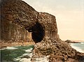
 The cliffs of Eshaness, North Mainland, Shetland
Credit: ThoWi
-
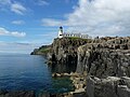 Neist Point Lighthouse on Skye was designed by David Alan Stevenson and dates from 1909
Credit: Lionel Ulmer
-
-
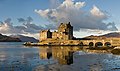 Eilean Donan Castle at the confluence of three sea lochs, Loch Duich, Loch Long and Loch Alsh
Credit: Diliff
-
 Baile Mòr, the village on Iona
Credit: Clydecoast
-

-

-
 Aerial view of the ruins of a hermitage on Canna
Credit: Peter Van den Bossche
-
 The Corryvreckan Whirlpool in the narrow Gulf of Corryvreckan between Jura and Scarba
Credit: Walter Baxter
-
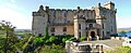
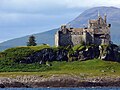 Duart Castle, a 13th-century castle on Mull, the historical seat of Clan Maclean
Credit: Philippe Giabbanelli
-
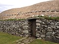 Blackhouses were the traditional form of house across the Hebrides and the Highlands; this example is at Arnol, Lewis
Credit: LornaMCampbell
-
 Rubha nan Gall lighthouse, Tobermory, Mull, built in 1857 by David and Thomas Stevenson, with a Caledonian MacBrayne ferry in the background
Credit: Colin
-
 Skye Bridge, opened in 1995; the toll was lifted in 2004
Credit: Gene Selkov
-

-

-
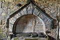 Alasdair Crotach MacLeod is the first McLeod not to be buried on Iona; his tomb on Harris dates from 1528, and is among the finest of this period in Scotland
Credit: Gvdwiele
-
 The tied island of St Ninian's Isle is joined to the Shetland Mainland by the largest tombolo in the UK
Credit: ThoWi
-
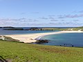
 Barra Airport is the only one in the world to use a beach as a regular runway
Credit: Steve Houldsworth
-
-
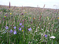 Wildflowers in machair, a coastal dune grassland found in the Outer Hebrides and elsewhere
Credit: Jon Thomson
-
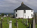 Kilarrow Parish Church, known as the Round Church, is a Georgian building in Bowmore on Islay
Credit: Ronsteenvoorden

.jpg)


.jpg)


.jpg)
.jpg)


_2.jpg)


.jpg)


Selected island group

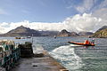
The Islands of the Firth of Clyde are the fifth largest of the major Scottish island groups after the Inner and Outer Hebrides, Orkney and Shetland. They are situated in the Firth of Clyde between Argyll and Bute in the west and Inverclyde, North Ayrshire and South Ayrshire in the east. There are about forty islands and skerries. Only four are inhabited, and only nine are larger than 40 hectares (99 acres). The largest and most populous are Arran and Bute. They are served by dedicated ferry routes, as are Great Cumbrae and Holy Island. Unlike the isles in the four larger Scottish archipelagos, none of the isles in this group are connected to one another or to the mainland by bridges.
The geology and geomorphology of the area is complex, and the islands and the surrounding sea lochs each have distinctive features. The influence of the Atlantic Ocean and the North Atlantic Drift create a mild, damp oceanic climate. There is a diversity of wildlife, including three species of rare endemic trees.
The larger islands have been continuously inhabited since Neolithic times. The cultures of their inhabitants were influenced by the emergence of the kingdom of Dál Riata, beginning in 500 AD. The islands were then politically absorbed into the emerging kingdom of Alba, led by Kenneth MacAlpin. During the early Middle Ages, the islands experienced Viking incursions. In the 13th century, they became part of the Kingdom of Scotland. (Full article...)
News

- 12 February: The BiFab construction yard at Arnish near Stornoway, Isle of Lewis, is purchased by InfraStrata.
- 11 February: Wild fires occur in Benbecula; and at Achmore and Sildinish in the Isle of Lewis; Horsaclete in Harris; Brevig in Barra; and Eubhal in North Uist.
- 19 January: Barra and Vatersay are put under tier-4 restrictions after an outbreak of Covid-19.
- 18 January: The Shetland Space Centre submits plans for a spaceport on Unst (proposed site pictured), Shetland, including three rocket launch pads.
- 8 January: Distilleries in Orkney and South Uist receive government grants to research ways of reducing their CO2 emissions.
- 4 January: After the UK leaves the European Union, the Northern Celt, an Irish fishing boat based out of Greencastle, County Donegal, is ordered to leave the 12-nautical-mile zone around Rockall by officers of Marine Scotland.
- 1 January: A total of 72 cases of Covid-19 are recorded in an ongoing outbreak in Shetland.
- 9 December: A review by a committee of MSPs into the commissioning and building of two new dual-fuel Caledonian MacBrayne ferries, MV Glen Sannox and "hull 802", criticises CMAL, Transport Scotland and the Scottish government, as well as the ship builders, Ferguson Marine.
- 3 December: North-east Lewis, Sea of the Hebrides and Shiant East Bank are designated Marine Protected Areas, while East Mainland Coast Shetland, Sound of Gigha, Coll and Tiree, Rùm, the west coast of the Outer Hebrides, and the waters off St Kilda and Foula are designated Special Protection Areas.
- 30 November: Michael Russell, MSP for Argyll and Bute, and David Stewart and John Finnie, MSPs for the Highlands and Islands region, will stand down at the 2021 election.
- 17 November: Phytophthora ramorum-infected larch trees in Arran are to be felled over a 543-acre area, to prevent the fungus-like pathogen from spreading.
- 4 November: The Scottish Wildlife Trust objects to a proposed salmon farm in the Marine Protected Area of Wester Ross, near Horse Island, Summer Isles, because of the potential impact on kelp forests and maerl beds.
Selected fauna
_specimen,_Kelvingrove,_Glasgow_-_geograph.org.uk_-_1108249.jpg)
The great auk (Pinguinus impennis) is a species of flightless alcid that became extinct in the mid-19th century. It was the only modern species in the genus Pinguinus. It is not closely related to the Southern Hemisphere birds now known as penguins, which were discovered later by Europeans and so named by sailors because of their physical resemblance to the great auk, which were called penguins.
It bred on rocky, remote islands with easy access to the ocean and a plentiful food supply, a rarity in nature that provided only a few breeding sites for the great auks. When not breeding, they spent their time foraging in the waters of the North Atlantic, ranging as far south as northern Spain and along the coastlines of Canada, Greenland, Iceland, the Faroe Islands, Norway, Ireland, and Great Britain.
The bird was 75 to 85 centimetres (30 to 33 inches) tall and weighed about 5 kilograms (11 pounds), making it the largest alcid to survive into the modern era, and the second-largest member of the alcid family overall (the prehistoric Miomancalla was larger). It had a black back and a white belly. The black beak was heavy and hooked, with grooves on its surface. During summer, great auk plumage showed a white patch over each eye. During winter, the great auk lost these patches, instead developing a white band stretching between the eyes. The wings were only 15 cm (6 in) long, rendering the bird flightless. Instead, the great auk was a powerful swimmer, a trait that it used in hunting. Its favourite prey were fish, including Atlantic menhaden and capelin, and crustaceans. Although agile in the water, it was clumsy on land. Great auk pairs mated for life. They nested in extremely dense and social colonies, laying one egg on bare rock. The egg was white with variable brown marbling. Both parents participated in the incubation of the egg for around six weeks before the young hatched. The young left the nest site after two to three weeks, although the parents continued to care for it.
The great auk was an important part of many Native American cultures, both as a food source and as a symbolic item. Many Maritime Archaic people were buried with great auk bones. One burial discovered included someone covered by more than 200 great auk beaks, which are presumed to be the remnants of a cloak made of great auks' skins. Early European explorers to the Americas used the great auk as a convenient food source or as fishing bait, reducing its numbers. The bird's down was in high demand in Europe, a factor that largely eliminated the European populations by the mid-16th century. Scientists[who?] soon began to realize that the great auk was disappearing and it became the beneficiary of many early environmental laws, but these proved ineffectual. (Full article...)
Selected history & culture article
Feb2007.jpg)
Jarlshof (/ˈjɑːrlzhɒf/ YARLZ-hof) is the best-known prehistoric archaeological site in Shetland, Scotland. It lies in Sumburgh, Mainland, Shetland and has been described as "one of the most remarkable archaeological sites ever excavated in the British Isles". It contains remains dating from 2500 BC up to the 17th century AD.
The Bronze Age settlers left evidence of several small oval houses with thick stone walls and various artefacts including a decorated bone object. The Iron Age ruins include several different types of structures, including a broch and a defensive wall around the site. The Pictish period provides various works of art including a painted pebble and a symbol stone. The Viking Age ruins make up the largest such site visible anywhere in Britain and include a longhouse; excavations provided numerous tools and a detailed insight into life in Shetland at this time. The most visible structures on the site are the walls of the Scottish period fortified manor house, which inspired the name "Jarlshof" that first appears in an 1821 novel by Walter Scott.
The site is in the care of Historic Scotland and is open from April to September. In 2012 "Zenith of Iron Age Shetland" including Mousa, Old Scatness and Jarlshof was added to the UK's tentative list of proposed World Heritage Sites. (Full article...)
Selected island
Lismore (Scottish Gaelic: Lios Mòr, pronounced [ʎis̪ ˈmoːɾ] possibly meaning "great enclosure" or "garden") is an island of some 2,351 hectares (9.1 square miles) in the Inner Hebrides of Scotland. The climate is damp and mild, with over 166 centimetres (65 in) of rain recorded annually. This fertile, low-lying island was once a major centre of Celtic Christianity, with a 6th-century monastery associated with Saint Moluag, and later became the seat of the medieval Bishop of Argyll. There are numerous ruined structures, including a broch and two 13th-century castles.
During the 19th century, various new industries were introduced, including lime quarrying. During the early decades of the 20th century, the population exceeded 1,000, but this was followed by a lengthy decline. Although resident numbers are now less than 200, there was a small increase from 2001 to 2011. About a third of the population were recorded as Gaelic-speaking at the former date. The modern economy is largely based on farming, fishing and tourism, and the largest settlement is Achnacroish. Various shipwrecks have been recorded in the vicinity. (Full article...)
Did you know?

- ... that the outlying islands of Scotland include the highest sea stack in the British Isles and one of the most isolated islets (pictured) in the oceans of the world?
- ... that Brodir and Ospak of Man were two 11th-century Danish brothers who fought on opposite sides at the Battle of Clontarf in 1014?
- ... that the German dreadnought battleship SMS König Albert was the only German dreadnought active at the time to miss the Battle of Jutland, due to engine problems?
- ... that the existence of a sea monster in Scotland has finally been proven?
Selected portrait
-

-
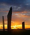 The Standing Stones of Stenness, near Stromness, Orkney, started by 3100 BC and possibly Britain's oldest henge site
Credit: Fantoman400
-
 Seals hauled out by Lyrie Geo on Hoy
Credit: Claire Pegrum
-
 Columba was a 6th-century Irish-born saint who spread Christianity in Scotland and founded Iona Abbey, where he is commemorated in this stained-glass window
Credit: Vegansoldier
-
 The 8th-century Kildalton Cross, Islay, one of the best-preserved Celtic crosses in Scotland
Credit: Tom Richardson
-
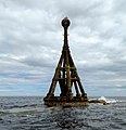 The North Carr Beacon at low tide; the unlit beacon was built between 1813 and 1821 by Robert Stevenson to warn shipping of the North Carr Reef near Fife Ness
Credit: Kathrinpassig
-
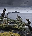 Puffins and guillemots on Lunga in the Treshnish Isles, with Bac Mòr (known as Dutchman's Cap for its distinctive shape) in the background
Credit: Simaron
-

-

-

-
 Scottish Gaelic speakers in the 2011 census; the Outer Hebrides, Tiree, Raasay, Skye and Lismore have the highest proportion of speakers
Credit: SkateTier
-

-


Selected geography article

Lochleven Castle is a ruined castle on an island in Loch Leven, in the Perth and Kinross local authority area of Scotland. Possibly built around 1300, the castle was the site of military action during the Wars of Scottish Independence (1296–1357). In the latter part of the 14th century, the castle was granted to William Douglas, 1st Earl of Douglas, by his uncle. It remained in the Douglases' hands for the next 300 years. Mary, Queen of Scots, was imprisoned there in 1567–68, and forced to abdicate as queen, before escaping with the help of her gaoler's family. In 1588, the queen's gaoler inherited the title of Earl of Morton, and moved away from the castle. In 1675, Sir William Bruce, an architect, bought the castle and used it as a focal point for his garden; it was never again used as a residence.
The remains of the castle are protected as a scheduled monument in the care of Historic Environment Scotland. Lochleven Castle is open to the public in summer, and access is available by ferry. (Full article...)
Selected biography

George Leslie Hunter (7 August 1877 – 7 December 1931) was a Scottish painter, regarded as one of the four artists of the Scottish Colourists group of painters. Christened simply George Hunter, he adopted the name Leslie in San Francisco, and Leslie Hunter became his professional name. Showing an aptitude for drawing at an early age, he was largely self-taught, receiving only elementary painting lessons from a family acquaintance. He spent fourteen years from the age of fifteen in the US, mainly in California. Hunter made an extended trip to Scotland, Paris and New York from 1903 to 1905. In 1906 he left San Francisco and returned to Scotland, painting and drawing there, notably in Fife and at Loch Lomond. Subsequently he travelled widely in Europe, especially in the South of France, but also in the Netherlands, the Pas de Calais and Italy. He also returned to New York in 1924 and 1928–1929.
Hunter painted a variety of still-lifes, landscapes and portraits, and his paintings are critically acclaimed for their treatment of light and the effects of light. Except, what Hunter set out to do was not about light, but to capture the essence of nature through pure colour. His paintings became popular with more progressive critics and collectors during his lifetime and have grown to command high prices since his death, becoming among the most popular in Scotland. (Full article...)
Related portals
Selected panorama
-
 Iona Abbey
Credit: Oliver-Bonjoch
-
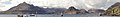
 Eilean Donan
Credit: Stefan Krause
-

-
-

-
-

-

-

-
-
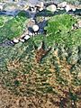
 Small freshwater islets on Loch Assynt
Credit: Vincent
-

Topics
|  | ||||||||||||||||
|
| |||||||||||||||||
| |||||||||||||||||
| |||||||||||||||||
| |||||||||||||||||
| |||||||||||||||||
| |||||||||||||||||
| |||||||||||||||||
Categories
The main category is Islands of Scotland, with subcategories

Things you can do
- Add new articles to the project by placing {{WPSI|class=|importance=}} on the talk page
- Add a link to the portal in the "See also" section of relevant articles with {{Portal|Scottish islands}}
- Take requested photographs or create requested pages, including Prehistoric Hebrides, Trialabreac, Dog Isle...
- Expand a Scottish Islands stub into a full article, adding images, citations, references and infoboxes; did you know that if you expand one 5x, you can nominate it for Did You Know?
- Improve one of the highest priority articles, including Mull, Bute, North & South Uist, Columba, Highland Clearances, Sorley MacLean, St Magnus Cathedral...
- Follow these hints to improve a B-class article and nominate it for Good Article

- Suggest articles, pictures, interesting facts, events and news to be featured here on the portal
Wikiproject

Associated Wikimedia
The following Wikimedia Foundation sister projects provide more on this subject:
-
 Commons
Free media repository -
 Wikibooks
Free textbooks and manuals -
 Wikidata
Free knowledge base -
 Wikinews
Free-content news -
 Wikiquote
Collection of quotations -
 Wikisource
Free-content library -
 Wikiversity
Free learning tools -
 Wikivoyage
Free travel guide -
 Wiktionary
Dictionary and thesaurus


