Chipita Park, Colorado
Appearance
This article needs additional citations for verification. (February 2013) |
Chipita Park | |
|---|---|
Unincorporated community | |
 Fountain Creek is a 74.5-mile-long (119.9 km) stream in El Paso and Pueblo counties, in Colorado in the United States. The creek flows southeast through the Ute Pass communities of Green Mountain Falls, Chipita Park, Cascade, Manitou Springs and on to Colorado Springs and Pueblo. | |
| Etymology: The wife of Chief Ouray | |
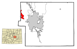
 This map shows the incorporated and unincorporated areas in El Paso County, Colorado, highlighting Cascade-Chipita Park in red. | |
| Coordinates: 38°56′36″N 105°00′08″W / 38.94333°N 105.00222°W[1] | |
| Country | United States |
| State | Colorado |
| Census-designated place | Cascade-Chipita Park |
| Elevation | 8,432 ft (2,570 m) |
| GNIS feature ID | 2407982[1] |
Chipita Park is an unincorporated community located in El Paso County, Colorado, named for the wife of Chief Ouray.[2]
Those who live in the Chipita Park area are also inhabitants of Cascade, Colorado. When receiving mail, they may put Chipita Park or Cascade for the city, as both refer to the Cascade-Chipita Park, Colorado census-designated place.
See also
[edit]References
[edit]- ^ a b c U.S. Geological Survey Geographic Names Information System: Chipita Park, Colorado
- ^ "Chipita Park Association: On the threshold of a new era". Chipita Park Association. Retrieved November 11, 2012.
