
Szólád
Szólád | |
|---|---|
Village | |
      Descending, from top: Reformed church (built in 1896), Monument of the heroes of the First World War, Country house, Roman Catholic church (built 1775-1782), Holy cross before the Roman Catholic church, Wine cellar | |
 Coat of arms | |
 | |
 Szólád Location of Szólád | |
| Coordinates: 46°47′00″N 17°51′00″E / 46.783333°N 17.85°E | |
| Country | |
| Region | Southern Transdanubia |
| County | Somogy |
| District | Siófok |
| RC Diocese | Kaposvár |
| Area | |
| • Total | 19.98 km2 (7.71 sq mi) |
| Population (2017) | |
| • Total | 484[1] |
| Demonym | szóládi |
| Time zone | UTC+1 (CET) |
| • Summer (DST) | UTC+2 (CEST) |
| Postal code | 8625 |
| Area code | (+36) 84 |
| Motorways | M7 |
| Distance from Budapest | 133 km (83 mi) Northeast |
| NUTS 3 code | HU232 |
| MP | Mihály Witzmann (Fidesz) |
| Website | Szólád Online |
Szólád is a village in Somogy county, Hungary.
The settlement is part of the Balatonboglár wine region.[2]
Main sights[edit]
- Reformed church (built in 1896)
- Monument of the heroes of the First World War
- Country houses
- Roman Catholic church (built between 1775 and 1782)
- Holy cross before the Roman Catholic church
- Wine cellars
Gallery[edit]
-
 Headboard monument for the Revolutions of 1848 and 1956
 -
 Wine cellar in Szólád
 -
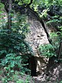 Wine cellar in Szólád
 -
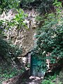
 Wine cellar in Szólád
 -
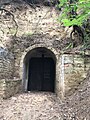
 Wine cellar in Szólád
 -
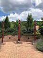
 Centre of Szólád


External links[edit]
References[edit]
Szólád's neighbours | ||||||||||||||||
|---|---|---|---|---|---|---|---|---|---|---|---|---|---|---|---|---|
| ||||||||||||||||
| Towns (3) |
| |
|---|---|---|
| Large village (1) | ||
| Villages (20) | ||


| Authority control databases: National |
|---|
This Somogy county location article is a stub. You can help Wikipedia by expanding it. |