The introductions of the country, dependency and region entries are in the native languages and in English. The other introductions are in English.
| |
|
Atlas-country

|
Canada
|
|
|
|
|
|
|
|
Canada
|
|
|
|
| English
|
Canada - Canada
Canada is the world's second-largest country by total area, occupying most of northern North America. Extending from the Atlantic Ocean to the Pacific Ocean and northward into the Arctic Ocean, Canada shares land borders with the ► United States to the south and to the northwest. To the east of Canada lies ► Greenland and to the south east ► Saint-Pierre and Miquelon is located. Further to the east lie the ► Azores. Canada is federal constitutional monarchy, with its capital Ottawa in Ontario. It consists of ten individual provinces and three territories.
|
| Français
|
Canada
Le Canada, deuxième pays du monde par sa superficie, occupe la majeure partie de l'Amérique du Nord. Il s'étend d'est en ouest de l'océan Atlantique à l'océan Pacifique et vers le nord jusqu'à l'océan Arctique. Le Canada partage deux frontières avec les États-Unis au sud et au nord-ouest (Alaska). Le Canada est un federation constituée de dix provinces et de trois territoires. Ottawa est la capital fédérale du pays.
|
|
|
|
| Short name
|
Canada
|
| Official name
|
Canada
|
| Status
|
Independent country since 1867
|
| Location
|
North America
|
| Capital
|
Ottawa
|
| Population
|
37,971,020 inhabitants
|
| Area
|
9,984,670 square kilometres (3,855,100 sq mi)
|
| Major languages
|
English and French (both official)
|
| Major religions
|
Roman Catholicism and Protestantism
|
| More information
|
Canada, Geography of Canada, History of Canada and Politics of Canada
|
| More images
|
Canada - Canada (Category).
|
|
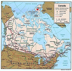
General maps

|
Map of Canada
Carte anglophone du Canada
|

|
Same map in French
Carte du Canada
|

|
Another map of the subdivisions of Canada
Une autre carte des subdivisions du Canada
|
|
Map of Canada
Carte du Canada
|

|
Topographic map of Canada
Carte topographique du Canada
|
Maps of divisions
This section holds maps of the administrative divisions.

|
The provinces, territories, and capitals of Canada
|

|
Provinces and territories of Canada
Provinces et territoires du Canada
|

|
Same map in French
Carte administrative du Canada
|
History maps
This section holds a short summary of the history of the area of present-day Canada, illustrated with maps, including historical maps of former countries and empires that included present-day Canada.

|
Map showing Scandinavian settlement in the eighth (dark red), ninth (red), tenth (orange) and eleventh (yellow) centuries. Areas denoted in green are those affected by frequent viking incursions but with little or no Scandinavian settlement.
Carte montrant la colonisation viking au Canada
|

|
Arctic cultures 800-1500
Cultures arctiques
|

|
Central Canada as part of the French colonial empire
Canada central comme une partie de l'Empire colonial français
|

|
Canada as part of the British colonial empire
Canada comme une partie de l'Empire britannique
|

|
Oregon border dispute
|
Images
-
1867: Dominion of Canada formed
-
1870: Most of British North America joins, Manitoba formed
-
1871: British Columbia joins
-
1873: Prince Edward Island joins
-
1875: Ontario expanded
-
1880: British Artic Islands join
-
1881: Manitoba expanded
-
1886: District of Keewatin adjusted
-
1889: Ontario expanded
-
1895: District of Keewatin expanded
-
1898: Yukon Territory formed, Quebec expanded
-
1901: Yukon Territory adjusted
-
1905: Alberta and Saskatchewan formed
-
1912: Manitoba, Quebec and Ontario expanded
-
1949: Newfoundland joins
-
1999: Nunavut formed
-
2001: Newfoundland renamed
Old maps
This section holds copies of original general maps more than 70 years old.

|
Il designo del discoperto della Nova Franza by Paolo Forlani, ca. 1566 – One of the first maps of North America to note the Canada's name ("pro.") (top right)
|

|
The East Coast of North America in 1702
|

|
Map of Canada in 1914
|
Legal maps

|
Status of same sex marriage before nationwide legalization
|
Other maps

|
National parks
|

|
Major Roads
|

|
Rivers
|

|
Railroads
|

|
Geological map
|

|
Countries that house a Canadian High Commission or embassy.
|
Satellite maps

|
Satellite map of Canada
|
Notes and references
General remarks:
- The WIKIMEDIA COMMONS Atlas of the World is an organized and commented collection of geographical, political and historical maps available at Wikimedia Commons. The main page is therefore the portal to maps and cartography on Wikimedia. That page contains links to entries by country, continent and by topic as well as general notes and references.
- Every entry has an introduction section in English. If other languages are native and/or official in an entity, introductions in other languages are added in separate sections. The text of the introduction(s) is based on the content of the Wikipedia encyclopedia. For sources of the introduction see therefore the Wikipedia entries linked to. The same goes for the texts in the history sections.
- Historical maps are included in the continent, country and dependency entries.
- The status of various entities is disputed. See the content for the entities concerned.
- The maps of former countries that are more or less continued by a present-day country or had a territory included in only one or two countries are included in the atlas of the present-day country. For example the Ottoman Empire can be found in the Atlas of Turkey.
|
Entries available in the atlas
- General pages
- World
- Continents and oceans
- Themes
- Historical eras
- States with wide recognition
- States with limited recognition
- Dependencies and other overseas territories
- Country subdivisions
- Belgium
- China (mainland)
- India
- Pakistan
- Spain
- United Kingdom
- United States
- Other
- Disputed subnational territories
- Other regions
- Cities
- Former sovereign states
- Former dependencies and overseas territories
- Former disputed territories
|

_-_CAN_-_UNOCHA.svg)
.svg)


 1867: Dominion of Canada formed
 1870: Most of British North America joins, Manitoba formed
 1871: British Columbia joins
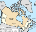 1873: Prince Edward Island joins
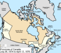 1875: Ontario expanded
 1880: British Artic Islands join
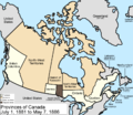 1881: Manitoba expanded
 1886: District of Keewatin adjusted
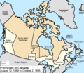 1889: Ontario expanded
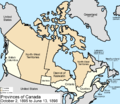 1895: District of Keewatin expanded
 1898: Yukon Territory formed, Quebec expanded
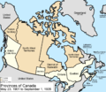 1901: Yukon Territory adjusted
 1905: Alberta and Saskatchewan formed
 1912: Manitoba, Quebec and Ontario expanded
 1949: Newfoundland joins
 1999: Nunavut formed
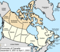 2001: Newfoundland renamed


