The introductions of the country, dependency and region entries are in the native languages and in English. The other introductions are in English.
| |
|
Atlas-country

|
Bosnia and Herzegovina
|
|
|
|
|
|
|
|
Bosna i Hercegovina
Босна и Херцеговина
|
|
|
|
| Bosanski
|
Bosna i Hercegovina (Federacija Bosne i Hercegovine / Republika Srpska)
Bosna i Hercegovina je država u jugoistočnom dijelu Evrope, smještena na zapadu Balkanskog poluotoka. Sa sjevera, zapada i jugo-zapada graniči sa Hrvatskom, a sa istoka sa Srbijom. Na jugo-istoku graniči sa Crnom Gorom. Glavni grad zemlje je Sarajevo. Nezavisnost je stekla 1. marta 1992. godine nakon odluke građana BiH referendumom o samoopredjeljenju. Prema međunarodnim procjenama, broj stanovništva iznosi 4,498,976 (2006, podaci CIA).
|
| Српски
|
Боснa и Херцеговинa (Федерација Босне и Херцеговине / Република Српска)
Босна и Херцеговина (БиХ) је држава у југоисточном делу Европе, смештена на западу Балканског полуострва. Састоји се од два ентитета: Републике Српске и Федерације БиХ. Са севера, запада и југа граничи са Хрватском, а са истока са Cрбијом и са Црном Гором. Главни град земље је Сарајево. Независност од бивше Југославије прогласила је 5. априла 1992.
|
| Hrvatski
|
Bosna i Hercegovina (Federacija Bosne i Hercegovine / Republika Srpska)
Bosna i Hercegovina je država u Europi, na zapadu Balkana. Graniči s Hrvatskom, Srbijom, i Crnom Gorom. Glavni grad je Sarajevo.
|
| English
|
Bosnia and Herzegovina - Bosnia and Herzegovina
Bosnia and Herzegovina is a country on the Balkan peninsula of southern Europe with an area of 51,129 km² (19,741 square miles), making it the 127th largest country by area, and an estimated population of around four million people. It borders to ► Serbia, ► Croatia and ► Montenegro. The country is a home to three ethnic "constituent peoples": Bosniaks, Serbs and Croats. Regardless of ethnicity, a citizen of Bosnia and Herzegovina is often identified in English as a Bosnian. In Bosnia, the pan-ethnic distinction between a Bosnian and a Herzegovinian is maintained. The country is decentralized and is administratively divided into two "entities", the ► Federation of Bosnia and Herzegovina and the ► Republika Srpska (Serbian Republic). The Federation of Bosnia and Herzegovina is primarily inhabited by Bosniaks and Bosnian Croats, which is why it is informally referred to as the Bosniak-Croat Federation.
|
|
|
|
| Short name
|
Bosnia and Herzegovina
|
| Official name
|
Bosnia and Herzegovina
|
| Status
|
Independent country since 1992
|
| Location
|
South East Europe
|
| Capital
|
Sarajevo
Сарајево
|
| Population
|
3,531,159 inhabitants
|
| Area
|
51,197 square kilometres (19,767 sq mi)
|
| Major languages
|
Bosnian, Serbian, Croat (all official)
|
| Major religions
|
Islam, Serbian Orthodox Church, Roman Catholicism
|
| More information
|
Bosnia and Herzegovina, Geography of Bosnia and Herzegovina, History of Bosnia and Herzegovina and Politics of Bosnia and Herzegovina
|
| More images
|
Bosnia and Herzegovina - Bosnia and Herzegovina (Category).
|
|
General maps

|
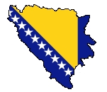
Flag map
|
|
Flag map
|

|
Topographic map
|
History maps
This section holds a short summary of the history of the area of present-day Bosnia and Herzegovina, illustrated with maps, including historical maps of former countries and empires that included present-day Bosnia and Herzegovina.
Early history

|
Illyrian ethnogenesis
|

|
Prehistoric Illyrian sites and cultures
|

|
Prehistoric Illyrian sites and cultures
|

|
Iron Age Glasinac culture (around 300 BC)
|

|
Illyrian language in antiquity
|

|
Ethnic territory of the Illyrians and Illyrian tribes (8th-3rd century BC)
|

|
Illyrian tribes in the Balkans
|

|
Illyrian tribes in the Balkans
|

|
Illyrians, Illyria Barbara, Illyria Graeca, Illyrians Proper and Environs
|

|
Approximate extent of the Illyrian territories prior to Roman conquest
|

|
Illyrian tribes in the Balkans
|

|
Illyrian tribes in the Balkans
|

|
Map of ancient settlements and roads in Bosnia and Herzegovina
|

|
Territorial development of the Roman Empire 264 BC-192, including the conquest of present-day Bosnia and Herzegovina
|

|
The extent of the Roman Republic and Roman Empire; 44 BC (late Republic, after conquests by republican generals) AD 14 (death of Augustus) |

|
Illyrian tribes in 6 AD
|

|
Great Illyrian uprising
|

|
Illyrian uprising in 6 AD
|

|
Illyrian uprising in 7 AD
|

|
Illyrian uprising in 8 AD
|

|
Illyrian uprising in 9 AD
|

|
Camps of the Roman Legions in 80
|

|
Roman provinces in BiH, 1st century
|

|
Roman provinces in the territory of BiH, 1st-2nd century
|

|
Roman Province of Dalmatia
|

|
Roman provinces in the territory of BIH, 2nd century
|

|
Territory of emperor Galerius during the Tetrarchy, 3rd-4th century
|

|
Prefecture of Illyricum, 318-379
|

|
Prefecture of Illyricum in the 4th century
|

|
Prefecture of Illyricum in the 4th century
|

|
Roman provinces, 4th century
|

|
The division of the Empire after the death of Theodosius I, ca.395 AD superimposed on modern borders.
|

|
Invasions of the Roman Empire 100-500
|

|
Division of the Roman Empire in 406
|

|
Eastern Roman Empire
|

|
Eastern Roman Empire under emperor Justinianus
|

|
Eastern Roman Empire under emperor Justinianus
|

|
Migration of the Slavs (5th-10th century)
|

|
Kingdom of Ostrogoths in 526
|

|
Kingdom of Ostrogoths
|

|
Slavic peoples (6th-7th century)
|

|
Slavic peoples (7th-8th century)
|

|
Presence of South Slavic tribes c. 700
|

|
Western Balkans in 800
|

|
Historical principalities of Zahumlje and Travunia in the 9th century
|

|
The Byzantine Empire under Basil II, c. 1025
|

|
Byzantine Empire 1025
|

|
Bosnia and Zahumlje in 1050
|

|
territorial development of medieval Bosnian state from early medieval times, before 10th century to 15th century, prior to Ottoman conquest
|

|
Map of the Byzantine Empire under Manuel Komnenos, c.1170.
|

|
Byzantine Empire 1180
|

|
Bosnia in 1189
|

|
Bosnia in 1265
|

|
Kingdom of Hungary in the 13th century - Banates of Bosnia, Soli, Usora and Slavonia
|

|
Bosnia, first half of the 14th century
|

|
Bosnia in 1322
|

|
Bosnia in 1322
|

|
Bosnia in 1326
|

|
Bosnia in 1326
|

|
Bosnia in 1340
|

|
Bosnian state in 1350
|

|
Bosnian state in 1350
|
| [[|border|251x400px]]
|
Bosnian state in the middle of the 14th century
|

|
Bosnian state in 1355
|

|
Bosnian state in 1355
|

|
State of župan Nikola Altomanović (1367-1373)
|

|
Bosnia in 1373
|

|
Bosnia, 1322-1389
|

|
Bosnia in 1390
|

|
Bosnia in 1390
|

|
Bosnia in 1390
|

|
Bosnian state in the 14th century
|

|
Bosnian state in the 14th century
|

|
Bosnian state first half of the 15th century, and before Ottoman conquest - Realms of Hrvoje Vukčić, Sandalj Hranić, and Pavle Radenović, with Usora and Soli, and royal demesne.
|

|
Bosnia and Herzegovina in 15th century.
|

|
State of Herzegovina in 1440
|

|
State of Herzegovina in 1440
|

|
State of Herzegovina in 1440
|

|
Herzegovina before Turkish invasions
|

|
Bosnian Frontier in 1455
|

|
BIH in 1482
|

|
Roman Catholic monasteries in Bosnia in the 15th century
|

|
Border between Kingdom of Hungary and Ottoman Empire in 1490
|

|
Border between Kingdom of Hungary and Ottoman Empire in the early 16th century
|

|
BIH in 1526
|

|
Growth of the Ottoman Empire
|

|
Development of the European part of the Ottoman Empire
|

|
Growth of the Ottoman Empire
|

|
Growth of the Ottoman Empire
|

|
Bunjevci migration
|

|
Serbian Patriarchate of Peć (16th-17th century)
|

|
Ottoman Empire in 1600
|

|
Bosnia in 1606
|
| [[|border|251x400px]]
|
Bosnia in the seventeenth century
|

|
Franciscan province Bosnia Argenta in 1679
|

|
Location of the Ottoman Empire in 1683
|

|
Ottoman Empire in 1683
|

|
Ottoman Empire in 1683
|

|
Bosnia Eyalet in 1683
|

|
Habsburg possesions, 1718-1739
|

|
Ottoman Empire in 1830
|

|
Bosnia and Herzegovina in 1848
|

|
Balkans after 1856
|

|
Bosnia and Herzegovina in 1868
|

|
Bosnia and Herzegovina in 1878
|

|
Ethnic map of Austria-Hungary, census 1880. German version
|

|
Religions in Austria-Hungary, Andrees Allgemeiner Handatlas, 1st Edition, Leipzig (Germany) 1881
|

|
Bosnia and Herzegovina in 1885
|

|
Ethnic map of Austria-Hungary, census 1890. English version
|

|
Austria-Hungary in 1899
|

|
Bosnia and Sandžak in 1904
|

|
Bosnia and Herzegovina in 1908
|

|
Kingdoms and countries of Austria–Hungary, see 18. Bosnia and Herzegovina
|
| [[|border|251x400px]]
|
Lands offered to Serbia by the London agreement in 1915
|

|
State of Slovenes, Croats and Serbs in 1918
|

|
Kingdom of Serbs, Croats and Slovenes in 1919
|
| [[|border|251x400px]]
|
After World War I, BIH became in 1918 part of the Kingdom of Serbs, Croats and Slovenes, renamed into Yugoslavia in 1929. This is a map of Yugoslavia in 1930
|

|
Banovinas in Yugoslavia
|

|
Banovinas in Yugoslavia
|

|
Banovinas in Yugoslavia
|

|
Banovinas in Yugoslavia
|

|
Banovinas in Yugoslavia
|

|
Drina banovina in 1931
|

|
Vrbas banovina (1929-1941)
|

|
Vrbas banovina in 1931
|

|
Vrbas banovina in 1939
|

|
Zeta banovina
|

|
German invasion of Yugoslavia in 1941
|

|
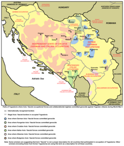
BIH in NDH in 1941-1945
|

|
BIH in NDH in 1941-1945
|

|
BIH in NDH in 1943
|

|
BIH in NDH in 1941
|

|
BIH in NDH in 1941
|

|
BIH in NDH in 1943
|

|
BIH in NDH in 1941-1945
|

|
BIH in NDH in 1941-1945
|

|
BIH in NDH in 1941-1945
|

|
BIH in NDH in 1941-1945
|

|
BIH in NDH in 1941-1945
|
|
Fascist genocide in WW2
|

|
Fascist concentration camps in WW2
|

|
Short-lived partisan Republic of Bihać in 1942
|

|
Short-lived partisan Republic of Bihać in 1942
|

|
Movement of JVuO troops in 1945
|

|
Bosnia and Herzegovina in the Socialist Federal Republic of Yugoslavia, 1945-1992
|

|
Bosnia and Herzegovina in the Socialist Federal Republic of Yugoslavia, 1945-1992
|

|
Bosnia and Herzegovina in the Socialist Federal Republic of Yugoslavia, 1945-1992
|

|
Bosnia and Herzegovina in the Socialist Federal Republic of Yugoslavia, 1945-1992
|

|
Bosnia and Herzegovina in the Socialist Federal Republic of Yugoslavia, 1945-1992
|

|
Bosnia and Herzegovina in the Socialist Federal Republic of Yugoslavia, 1945-1992
|

|
Bosnia and Herzegovina in the Socialist Federal Republic of Yugoslavia, 1945-1992
|
Maps of the Bosnian War

|
Serbian autonomous oblasts in Bosnia and Herzegovina (1991-1992)
|

|
Serbian autonomous oblasts in Bosnia and Herzegovina (1991-1992)
|

|
An animated series of maps showing the breakup of the second Yugoslavia
|

|
Wartime 1992
|

|
Wartime 1992
|

|
Bosniak-Croat war
|

|
lines of front in 1994 after the time of signing Washington agreement. HVO blue, A BiH green, VRS red
|

|
lines of front in 1994
|

|
lines of front in 1995
|

|
lines of front in 1995 - Croat and Bosniak advance
|
| [[|border|251x400px]]
|
BiH territories which were during the war controled by A BiH for some time
|

|
BiH territories that were controlled by HVO and regular Croatian Army for some time during the war.
|

|
BiH territories which were during the war controled by VRS (Army of Republika Srpska) for some time
|

|
Front lines before Dayton
|
Maps of the Bosnian peace plans

|
First Muslim cantonization proposal
|

|
HDZ-SDA cantonization proposal in 1992
|
Post-war history

|
Map of Dayton agreement (1995)
|

|
Map of Dayton agreement (1995)
|

|
Municipal borders, 1992-1995
|

|
BIH after Dayton agreement
|

|
BIH after Dayton agreement
|

|
BIH after Dayton agreement
|

|
BIH after Dayton agreement
|

|
BIH after Dayton agreement
|

|
BIH after Dayton agreement
|

|
BIH after Dayton agreement
|

|
Brčko area after Dayton agreement (1995-2000)
|

|
Territiories on which Croatian homerule was proclaimed in 2001
|

|
Former Yugoslavia compared with the present borders (2006)
|

|
Former Yugoslavia compared with the present borders (2006)
|

|
Minefield map as of 2008
|

|
Central Balkans in 2010 (de facto situation). Note: Serbia does not recognizing Independence of Kosovo.
|
Ethnic, linguistic and religion maps

|
Confessional map in 1910
|

|
Confessional map in 1910
|

|
Confessional map in 1935. Colors selected to suit other BiH maps in Wikimedia Commons
|

|
Religions in BiH in 1953
|

|
Catholics in BiH in 1953
|

|
Ethnic distribution within Bosnia in 1961 (in Serbian)
|

|
BiH ethnic relationship map in 1981
|

|
Serbs in BIH in 1981
|

|
BiH ethnic relationship map in 1991
|

|
BiH ethnic relationship map in 1991
|

|
BiH ethnic relationship map in 1991
|

|
BiH ethnic relationship map in 1991
|

|
BiH ethnic relationship map in 1991
|

|
BiH ethnic relationship map in 1991
|

|
BiH ethnic relationship map in 1991 within 2008 municipal borders
|

|
Bosniaks in the region
|

|
Population change in BiH Serb population by municipalities in period 1991-2005. Yellow are municipalities in which Serbs had less than 10% in census of 1991, dark red are municipalities in which theirs percentage has grown by more than 5 percent by the year 2005 and grey are municipalities in which their percentage has fallen by more than 5 percent in that period.
|

|
Ethnic Croat municipalities in BiH
|

|
Ethnic map of Bosnia and Herzegovina, 2006 municipality data. Bosniaks - green, Serbs - blue, Croats - red.
|

|
Roma people in BIH
|

|
Serbo-Croatian language in Bosnia and Herzegovina (as of 2005)
|

|
Ethno-political variants of the Serbo-Croatian language in Bosnia and Herzegovina (as of 2006)
|

|
Ethno-political variants of the Serbo-Croatian language in Bosnia and Herzegovina (as of 2006)
|

|
Historical distribution of Serbo-Croatian dialects (before 16th century migrations)
|

|
Historical Serbo-Croatian dialects in Bosnia and Herzegovina
|

|
Historical Serbo-Croatian dialects in Bosnia and Herzegovina
|

|
Serbo-Croatian dialects in Bosnia and Herzegovina
|

|
Shtokavian Serbo-Croatian dialects in Bosnia and Herzegovina
|

|
Shtokavian Serbo-Croatian dialects in Bosnia and Herzegovina
|

|
Shtokavian Serbo-Croatian dialects in Bosnia and Herzegovina
|

|
Eparchies of the Serbian Orthodox Church in Bosnia and Herzegovina
|

|
Roman Catholic Dioceses in Bosnia and Herzegovina
|
Administrative units

|
Cantons of Federation
|

|
District Brčko
|

|
District Brčko
|
Geographical regions

|
Bosnia region
|

|
Herzegovina region
|

|
Herzegovina region
|

|
Herzegovina region
|

|
Bosanska Krajina region
|

|
Bosanska Krajina region
|

|
Posavina region
|
| [[|border|251x400px]]
|
Neum
|

|
Neum
|
Politics

|
1990 elections
|

|
2008 elections
|
Old maps

|
Bosnia and Herzegovina in 1897
|

|
Historical map of Austria-Hungary from the Bibliothek allgemeinen und praktischen Wissens für Militäranwärter Band I, 1905
|
Other maps

|
Bosnia and Herzegovina with EU flag
|
Satellite maps

|
Satellite map
|
Notes and references
General remarks:
- The WIKIMEDIA COMMONS Atlas of the World is an organized and commented collection of geographical, political and historical maps available at Wikimedia Commons. The main page is therefore the portal to maps and cartography on Wikimedia. That page contains links to entries by country, continent and by topic as well as general notes and references.
- Every entry has an introduction section in English. If other languages are native and/or official in an entity, introductions in other languages are added in separate sections. The text of the introduction(s) is based on the content of the Wikipedia encyclopedia. For sources of the introduction see therefore the Wikipedia entries linked to. The same goes for the texts in the history sections.
- Historical maps are included in the continent, country and dependency entries.
- The status of various entities is disputed. See the content for the entities concerned.
- The maps of former countries that are more or less continued by a present-day country or had a territory included in only one or two countries are included in the atlas of the present-day country. For example the Ottoman Empire can be found in the Atlas of Turkey.
|
Entries available in the atlas
- General pages
- World
- Continents and oceans
- Themes
- Historical eras
- States with wide recognition
- States with limited recognition
- Dependencies and other overseas territories
- Country subdivisions
- Belgium
- China (mainland)
- India
- Pakistan
- Spain
- United Kingdom
- United States
- Other
- Disputed subnational territories
- Other regions
- Cities
- Former sovereign states
- Former dependencies and overseas territories
- Former disputed territories
|


.svg)
.png)
.jpg)


.svg)
.svg)
.png)
.svg)


.svg)


.png)


.PNG)


.PNG)


.jpg)

.jpg)


.png)


.png)


.png)

.png)

.jpg)

.png)
.JPG)


.png)


