
User:RandomInfinity17
Hello! I track tropical and subtropical cyclones around the world.
| This user participates in WikiProject Tropical cyclones. |
| This user participates in the Non-tropical storms task force. |
| This user likes tracking tropical cyclones. |
| This user is really fascinated by the weather. |
| This user is interested in severe weather. |
| This user is a participant in WikiProject Weather |
| This user's most intense tropical cyclone ever experienced was Hurricane Marie in 2014. |
Interesting weather and space images[edit]
-
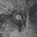
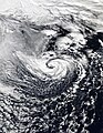
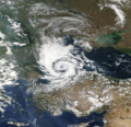 A possible subtropical cyclone in the Black Sea on September 27, 2005.
 -
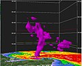 Radar scan of the 2021 Western Kentucky tornado lifting debris from the town of Mayfield 30,000 feet into the atmosphere.
 -
 Storm Dennis, the most intense European windstorm of the 21st century, on February 15, 2020.
 -

-
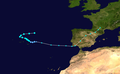 Track of Tropical Storm Five of the 1952 Atlantic hurricane season, the northernmost forming Atlantic tropical cyclone.
 -
 A house that was wiped off its foundation after the extremely violent 2011 Hackleburg–Phil Campbell tornado.
 -

-
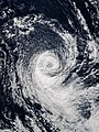 Subtropical Cyclone Katie near Easter Island on May 2, 2015.
 -
 One of the first photos of the Andromeda Galaxy, taken in 1899 by Issac Roberts.
 -
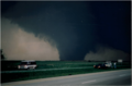 Image of the 1997 Jarrell tornado at peak intensity over the Double Creek Estates in Jarrell, Texas.
 -
 Satellite image of the 2022 Hunga Tonga–Hunga Haʻapai eruption and the extratropical remnants of Cyclone Cody.
 -
 Radar loop of the most prolific December tornado outbreak on record on December 15, 2021.
 -
 Cryovolcanoes spewing out ice at the south pole of Enceladus.
 -
 Hurricane Dorian approaching Canada as powerful extratropical cyclone on September 7, 2019.
 -
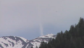 An unrated landspout tornado near Marble, Colorado on May 29, 2021.
 -
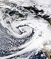 A record-breaking bomb cyclone off the coast of the Pacific Northwest on October 24, 2021.
 -
 Subtropical Storm One at peak intensity on January 16, 2023.
 -
 C/2022 E3 (ZTF), a long-period comet, on January 27, 2023.
 -
 A waterspout inside of Tropical Storm Colin on June 6, 2016.
 -
 Track of Cyclone Freddy, the longest-lived tropical cyclone on record.
 -
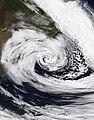
 A potential subtropical storm of the coast of Morroco on February 17, 2002.
 -
 The 1904, Moscow tornado, one of the deadliest Russian tornadoes on record.
 -
 2023 CX1 entering Earth's atmosphere over France on February 13, 2023.
 -
 Subtropical Storm Raoni off the coast of Argentina on June 28, 2021


.jpg)


-_Alessandro_Bianconi.jpg)


Tropical cyclones in 2023 (personal analysis)[edit]

Subpages[edit]
My Subpages:
Good ones/Actively working on[edit]
- My sandbox
- Effects of the 1982–83 El Niño in Peru†
- Tropical Storm Namtheun (2021)†
- Unusual areas of tropical cyclogensis†
- Potential Tropical Cyclone Four†
- F6
- 2023 Naypyidaw tornado†
- List of costliest tropical cyclones
Inactive[edit]
- Significant tornadoes of 2023
- Table of Central Pacific tropical cyclones†
- Deadliest tropical cyclones by basin
Mainspace[edit]
- List of costliest tropical cyclones
- Template:Table of F5 and EF5 tornadoes
- Weather of 1985
- October 2022 Southern Ocean cyclone
† open to editing from others
My best works[edit]
- Weather of 2023 (
 / Top ) – Started article and contributed significantly to it by adding weather events as they go
 - Template:10 deadliest tornadoes worldwide and Template:F5 and EF5 tornadoes (
 ) – Started them and my contributions are most of the template content
 - List of costliest tropical cyclones (
 / Low ) – Started article and most of the article is my contribution, had to delete "some" but I still have the original still exists here
 - Hurricane Hilary (2023) (
 / Mid ) – Started article
 - Weather of 1985 (
 / Low ) – Started article and added all events
 - October 2022 Southern Ocean cyclone (/ Mid ) – Created article
Random Tropical Cyclone ()[edit]

Hurricane Bud was a Category 4 hurricane that brought winds and severe flooding to Mexico throughout its existence as a tropical cyclone in June 2018. It was the second named storm, hurricane, and major hurricane of the 2018 Pacific hurricane season.[1] Bud originated from a tropical wave that departed from Western Africa on May 29. It traveled across the Atlantic Ocean before entering the Northeast Pacific Ocean late on June 6. The system moved towards the northwest and steadily organized, becoming a tropical depression on June 9 and Tropical Storm Bud early the next day. Favorable upper-level winds, ample moisture aloft, and warm sea surface temperatures allowed the storm to rapidly intensify to a hurricane late on June 10, and further to a major hurricane on the following day. Bud ultimately peaked the next morning with maximum sustained winds of 140 mph (230 km/h) and a minimum central pressure of 943 mbar (943 hPa; 27.8 inHg). Its track curved more northward while the storm rapidly succumbed to the effects of upwelling. Bud made landfall on Baja California Sur as a minimal tropical storm early on June 15. On the next day, land interaction and increasing wind shear caused Bud to degenerate into a post-tropical cyclone. It opened up into a trough of low-pressure on June 16. The remnants of Bud moved towards the Southwestern United States, bringing tropical moisture and gusty winds to the region.
Bud prompted the issuance of multiple watches and warnings for Baja California Sur and western and central Mexico. Bud caused two deaths in Mexico; one in Mexico City and another in Baja California Sur. Despite remaining offshore for most of its track, the hurricane caused torrential rainfall and severe flooding in several regions. A peak rainfall total of 6.50 in (165 mm) was recorded in San Lorenzo, Sinaloa. In Guadalajara, Jalisco, hundreds of vehicles were inundated and swept away. A canal overflowed in Guadalajara, causing damage to multiple stores in a mall. At least 100 additional structures were damaged in the city. In Guerrero, hundreds of businesses and homes were flooded. Over 100 businesses in Pie de la Cuesta were damaged by strong waves. More than 60 homes in Maruata, Michoacan, experienced flood or wind damage. Severe flooding along a street in Mexico City inundated dozens of vehicles, necessitating the rescue of their passengers. Rains from Bud's remnants brought relief to drought-stricken areas and slowed the growth of wildfires in Wyoming and Colorado. The influx of moisture prompted the issuance of flash flood watches for Colorado and New Mexico, and caused flooding near Cave Creek, Arizona. (Full article...)
- ^ National Hurricane Center; Hurricane Research Division; Central Pacific Hurricane Center (April 26, 2024). "The Northeast and North Central Pacific hurricane database 1949–2023". United States National Oceanic and Atmospheric Administration's National Weather Service. Archived from the original on May 29, 2024. A guide on how to read the database is available here.
 This article incorporates text from this source, which is in the public domain.