Kisherend
Appearance
Kisherend | |
|---|---|
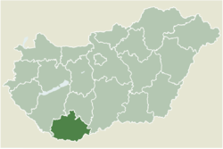
 Location of Baranya county in Hungary | |
| Coordinates: 45°57′57″N 18°19′57″E / 45.96571°N 18.33251°E | |
| Country | |
| County | Baranya |
| Government | |
| • Mayor | Varga Zsolt (Ind.) |
| Area | |
| • Total | 6.92 km2 (2.67 sq mi) |
| Population (2022)[3] | |
| • Total | 173 |
| • Density | 25/km2 (65/sq mi) |
| Time zone | UTC+1 (CET) |
| • Summer (DST) | UTC+2 (CEST) |
| Postal code | 7763 |
| Area code | 72 |
Kisherend (Croatian: Renda) is a village in Baranya county, Hungary.
References
[edit]- ^ "Település adatlap". Nemzeti Választási Iroda (in Hungarian). Retrieved 2 September 2024.
- ^ "Detailed Gazetteer of Hungary". www.ksh.hu. Retrieved 2 September 2024.
- ^ "Census 2022". Census 2022. Retrieved 2 September 2024.
External links
[edit]- Street map (in Hungarian)


