The introductions of the country, dependency and region entries are in the native languages and in English. The other introductions are in English.
| |
|
Atlas-country

|
El Salvador
|
|
|
|
|
|
|
|
El Salvador
|
|
|
|
| Español
|
El Salvador - República de El Salvador
La República de El Salvador es un país de clima tropical localizado en la América Central, con una población de aproximadamente 6.7 millones de habitantes. Debido a su extensión territorial (21,041 km²). Adquirió su independencia de España en 1821, y dejó de ser parte de las Provincias Unidas de Centroamérica en 1839. Anteriormente, se lo conocía con el nombre de Cuscatlán que significa "Tierra de Cosas Preciosas", en lengua Nahuat.
|
| English
|
El Salvador - Republic of El Salvador
The Republic of El Salvador is a country in Central America with a population of approximately 6.9 million people. It is bordered to the west by ► Guatemala, to the north and east by ► Honduras, and to the south by the Pacific Ocean. El Salvador is the most densely populated nation on the American mainland (especially in its capital, San Salvador) and the most industrialized nation in the region. The country was named after the Spanish word for "The Saviour," in honor of Jesus Christ, and its territory was known prehispanically as Cuscatlán. People from El Salvador are called "Salvadorans" (formally) and "Guanacos" (informally).
|
|
|
|
| Short name
|
El Salvador
|
| Official name
|
Republic of El Salvador
|
| Status
|
Independent country since 1821
|
| Location
|
Central America
|
| Capital
|
San Salvador
|
| Population
|
6,765,753 inhabitants
|
| Area
|
21,040 square kilometres (8,120 sq mi)
|
| Major languages
|
Spanish (official)
|
| Major religions
|
Roman Catholic
|
| More information
|
El Salvador, Geography of El Salvador, History of El Salvador and Politics of El Salvador
|
| More images
|
El Salvador - El Salvador (Category).
|
|
General maps

|
Map of El Salvador
|

|
Map of El Salvador with department borders
|

|
Relief map of El salvador
|

|
A Köppen climate classification map of El Salvador
|
Maps of divisions
This section holds maps of the administrative divisions.
-
Ahuachapan
-
Cabanas
-
Chalatenango
-
Cuscatlan
-
La Libertad
-
La Paz
-
Morazan
-
Santa Ana
-
San Miguel
-
San Salvador
-
San Vicente
-
Sonsonate
Note: The shaded areas correspond to territorial claims between Honduras and El Salvador as "los bolsones" that were resolved in 1992 by the International Court of Justice. However, these areas are still used on the country's official maps (the last two maps) for the demarcation of borders that have been fulfilled since 2006.
History maps
This section holds a short summary of the history of the area of present-day El Salvador, illustrated with maps, including historical maps of former countries and empires that included present-day El Salvador.

|
Maya civilization compared with present states
|

|
Maya languages
|

|
Pre-Spanish El Salvador
|

|
Federal Republic of Central America
|

|
Central America in 1892
|
Economy maps

|
Economy map
|

|
Vegetation and Land Use
|
Satellite maps

|
Satellite map (2002)
|
Notes and references
General remarks:
- The WIKIMEDIA COMMONS Atlas of the World is an organized and commented collection of geographical, political and historical maps available at Wikimedia Commons. The main page is therefore the portal to maps and cartography on Wikimedia. That page contains links to entries by country, continent and by topic as well as general notes and references.
- Every entry has an introduction section in English. If other languages are native and/or official in an entity, introductions in other languages are added in separate sections. The text of the introduction(s) is based on the content of the Wikipedia encyclopedia. For sources of the introduction see therefore the Wikipedia entries linked to. The same goes for the texts in the history sections.
- Historical maps are included in the continent, country and dependency entries.
- The status of various entities is disputed. See the content for the entities concerned.
- The maps of former countries that are more or less continued by a present-day country or had a territory included in only one or two countries are included in the atlas of the present-day country. For example the Ottoman Empire can be found in the Atlas of Turkey.
|
Entries available in the atlas
- General pages
- World
- Continents and oceans
- Themes
- Historical eras
- States with wide recognition
- States with limited recognition
- Dependencies and other overseas territories
- Country subdivisions
- Belgium
- China (mainland)
- India
- Pakistan
- Spain
- United Kingdom
- United States
- Other
- Disputed subnational territories
- Other regions
- Cities
- Former sovereign states
- Former dependencies and overseas territories
- Former disputed territories
|


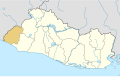 Ahuachapan
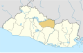 Cabanas
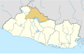 Chalatenango
 Cuscatlan
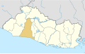 La Libertad
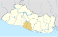 La Paz
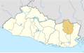 Morazan
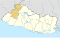 Santa Ana
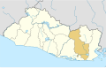 San Miguel
 San Salvador
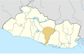 San Vicente
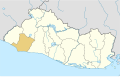 Sonsonate


