The introductions of the country, dependency and region entries are in the native languages and in English. The other introductions are in English.
| |
|
Atlas-country

|
Lithuania
|
|
|
|
|
|
|
|
Lietuva
|
|
|
|
| Lietuvių
|
Lietuva - Lietuvos Respublika
Lietuvos Respublika, valstybė pačiame geografinės Europos centre (Baltijos jūros pietrytinėje pakrantėje) ir Vakarų Europos civilizacinio arealo rytiniame pakraštyje. Ribojasi su šiomis valstybėmis: Latvija (sausumos sienos ilgis — 588 km, jūros siena — 22 km), Baltarusija (sienos ilgis — 677 km), Lenkija (sienos ilgis — 104 km), Rusija (Kaliningrado sritis) (sausumos sienos ilgis — 255 km, Kuršių mariomis — 18 km, jūra — 22 km). Baltijos jūros pakrantės ilgis — 90 km. Bendras Lietuvos sienos plotas - 1732 km.
|
| Polski
|
Litwa - Republika Litewska
Republika Litewska, państwo w Europie, jeden z krajów bałtyckich, członek Unii Europejskiej i NATO; graniczy od zachodu z Rosją (obwodem kaliningradzkim), od południowego zachodu z Polską, od wschodu z Białorusią, od północy z Łotwą.
|
| Русский
|
Литва́ - Лито́вская Респу́блика
Лито́вская Респу́блика государство в Европе, на восточном побережье Балтийского моря. На севере граничит с Латвией, на юго-востоке — с Белоруссией, на юго-западе — c Польшей и Калининградской областью России. Член НАТО (с 2004), ЕС (с 2004), ВТО, ООН.
|
| English
|
Lithuania - Republic of Lithuania
The Republic of Lithuania is a country in northern Europe. The largest of the three Baltic States situated along the Baltic Sea, it shares borders with ► Latvia to the north, ► Belarus to the southeast, ► Poland and the ► Russian enclave of the Kaliningrad Oblast to the southwest.
|
|
|
|
| Short name
|
Lithuania
|
| Official name
|
Republic of Lithuania
|
| Status
|
Independent country since at least the 13th century, interrupted between 1795 and 1918 as well as subject to soviet and nazi military occupation from 1940 to 1991, regained independence in 1991., member of the ► European Union since 2004
|
| Location
|
North Europe
|
| Capital
|
Vilnius
|
| Population
|
2,867,725 inhabitants
|
| Area
|
65,303 square kilometres (25,214 sq mi)
|
| Major languages
|
Lithuanian (official)
|
| Major religions
|
Roman Catholicism
|
| More information
|
Lithuania, Geography of Lithuania, History of Lithuania and Politics of Lithuania
|
| More images
|
Lithuania - Lithuania (Category).
|
|
In Lithuanian
General maps

|
Map of Lithuania
|

|
Map of Lithuania (German)[1]
|

|
High resolution map of Lithuania (blank or German language available)[2][3][4]
|

|
Physical map of Lithuania
|

|
Physical map
|

|
Physical map
|
Maps of divisions
This section holds maps of the administrative divisions.
-
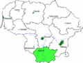
Alytus County
-
Utena County
-
Šiauliai County
-
Panevėžys County
-
Telšiai County
-
Tauragė County
-
Klaipėda County
-
Marijampolė County
-
Kaunas County
-
Vilnius County
History maps
This section holds a short summary of the history of the area of present-day Lithuania, illustrated with maps, including historical maps of former countries and empires that included present-day Lithuania.
Early history

|
Baltic Tribes around 1200
|
Independent Lithuania

|
Map showing changes in the territory of Lithuania from the 13th century to the present day:
- 13th century (during the reign of Mindaugas)
- 15th century (during the reign of Vytautas the Great)
- Polish-Lithuanian Commonwealth and border between its parts
- Border of 1923 (the area of Vilnius being a part of Poland)
- Modern Republic of Lithuania
|

|
Lithuania in the 13th and 15th century
|

|
The Monastic state of the Teutonic Knights 1308–1455
|

|
The Monastic state of the Teutonic Knights 1466
|

|
Lithuania and Poland in 1387
|

|
Lithuanian language areas in the 16th century
|
Polish Lithuanian Commonwealth

|
Map of the Commonwealth in 1569
|
Incorporation into the Russian Empire

|
The third partition meant the end of the Polish-Lithuanian Commonwealth and the final division between Prussia, Russia and Austria after 3rd partition
|

|
Lithuania's administrative divisions in the 17th century
|

|
Lithuania after 3rd partitions (1795)
|

|
The Russian Empire in 1866
|

|
History of the Russian Empire (in German)
|

|
Ethnic map of European Russia before the First World War (in French)
|

|
Lithuania in the Russian Empire (1867-1914)
|

|
Russia in 1912
|
Independent Lithuania in the interbellum

|
Lithuanian claims in Poland in 1920
|

|
Lithuania claims and the Republic of Central Lithuania
|

|
Changing border between Lithuania and Poland. In 1923 Lithuania occupies and annexes the ► Memel Territory in the "Klaipeda Revolt". The Memel Territory was a former ► German territory under protection of the League of Nations since 1920.
|
Soviet annexation

|
Lithuania is annexed by the Soviet Union in 1940. Location of the USSR
|

|
Evolution of the Soviet Union
|

|
The republics of the USSR
|

|
Soviet Lithuania
|
| [[|border|251x400px]]
|
Map of the 1974 geographic location of various ethnic groups within the Soviet Union
|

|
Soviet Union administrative divisions, 1989
|
Restored independence
History of other entities
Central Lithuania

|
1920-1922: Republic of Central Lithuania (Vidurio Lietuvos Respublika, Republika Litwy Środkowej, Рэспубліка Сярэдняе Літвы - Respublika Siaredniaje Litvy) -
|
|
|
Lithuania claims and the Republic of Central Lithuania
|
Klaipėda
|
|
1920-1923: Memel Territory (Memelgebiet, Klaipėdos kraštas) - territory under protection of the League of Nations
|

|
The Memel Territory Klaipėda Region (Lithuanian: Klaipėdos kraštas) or Memel Territory (German: Memelland or Memelgebiet; French: Territoire de Memel) was defined by the Treaty of Versailles in 1920 when it was put under the administration of the Council of Ambassadors. The Memel Territory, situated between the river and the town of that name, was occupied by Lithuania in the "Klaipeda Revolt" of 1923, returned to Germany in 1939, and made a part of the Lithuanian SSR in 1944.
|

|
Memel Territory annexed by Germany
|
Other maps

|
Population density
|

|
Ethnographic map
|

|
Litauische Ostseeküste
|
Satellite maps

|
Satellite map
|
Notes and references
General remarks:
- The WIKIMEDIA COMMONS Atlas of the World is an organized and commented collection of geographical, political and historical maps available at Wikimedia Commons. The main page is therefore the portal to maps and cartography on Wikimedia. That page contains links to entries by country, continent and by topic as well as general notes and references.
- Every entry has an introduction section in English. If other languages are native and/or official in an entity, introductions in other languages are added in separate sections. The text of the introduction(s) is based on the content of the Wikipedia encyclopedia. For sources of the introduction see therefore the Wikipedia entries linked to. The same goes for the texts in the history sections.
- Historical maps are included in the continent, country and dependency entries.
- The status of various entities is disputed. See the content for the entities concerned.
- The maps of former countries that are more or less continued by a present-day country or had a territory included in only one or two countries are included in the atlas of the present-day country. For example the Ottoman Empire can be found in the Atlas of Turkey.
- ↑ See for a Bulgarian version here.
- ↑ Blank version of this map: Image:Lithuania-blank.png
- ↑ High resolution topographic map of Lithuania (German): Image:Lithuania-topo-de.png
- ↑ Blank version of the above: Image:Lithuania-topo-blank.png
|
Entries available in the atlas
- General pages
- World
- Continents and oceans
- Themes
- Historical eras
- States with wide recognition
- States with limited recognition
- Dependencies and other overseas territories
- Country subdivisions
- Belgium
- China (mainland)
- India
- Pakistan
- Spain
- United Kingdom
- United States
- Other
- Disputed subnational territories
- Other regions
- Cities
- Former sovereign states
- Former dependencies and overseas territories
- Former disputed territories
References
|


 Alytus County
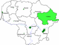 Utena County
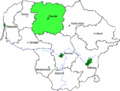 Šiauliai County
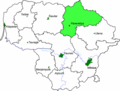 Panevėžys County
 Telšiai County
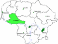 Tauragė County
 Klaipėda County
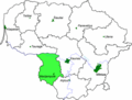 Marijampolė County
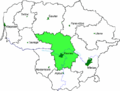 Kaunas County
 Vilnius County


