The introductions of the country, dependency and region entries are in the native languages and in English. The other introductions are in English.
| |
|
Atlas-country

|
Liechtenstein
|
|
|
|
|
|
|
|
Liechtenstein
|
|
|
|
| Deutsch
|
Liechtenstein - Fürstentum Liechtenstein
Das Fürstentum Liechtenstein ist ein souveräner Staat im mitteleuropäischen Alpenraum. Das Land liegt zwischen Österreich und der Schweiz am Ostufer des Rheins. Das Fürstentum gilt heute als konstitutionelle Erbmonarchie auf demokratisch-parlamentarischer Grundlage. Die Souveränität liegt sowohl beim Volk als auch beim Fürsten. Liechtenstein gliedert sich in elf Gemeinden, Hauptort und Fürstensitz ist Vaduz.
|
| English
|
Liechtenstein - Principality of Liechtenstein
The Principality of Liechtenstein is a small, doubly landlocked country in Central Europe, bordered by ► Switzerland to its west and by ► Austria to its east. Mountainous, it is a winter sports resort, though it is perhaps best-known as a tax haven. Despite this, it is not heavily urbanized (in the way that the Principality of Monaco and Gibraltar are). Many cultivated fields and little farms characterize its landscape both in the north (Unterland) and in the south (Oberland). It is the smallest German-speaking country in the world.
|
|
|
|
| Short name
|
Liechtenstein
|
| Official name
|
Principality of Liechtenstein
|
| Status
|
Independent country since 1806
|
| Location
|
Central Europe
|
| Capital
|
Vaduz
|
| Population
|
38,749 inhabitants
|
| Area
|
160 square kilometres (62 sq mi)
|
| Major languages
|
German (official)
|
| Major religions
|
Roman Catholicism
|
| More information
|
Liechtenstein, Geography of Liechtenstein, History of Liechtenstein and Politics of Liechtenstein
|
| More images
|
Liechtenstein - Liechtenstein (Category).
|
|
General maps

|
Location of Liechtenstein
|

|
Topographic map of Liechtenstein (in French)
|
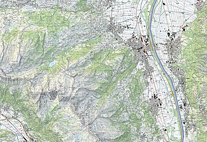
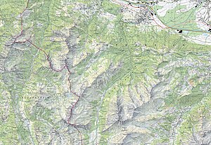
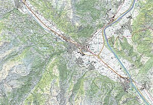
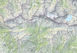
Swisstopo 1:25,000 topographic maps

|

|
|
|
|
|

|
Administrative map of Liechtenstein (in French)
|

|
Liechtenstein and surroundings
|
History maps
This section holds a short summary of the history of the area of present-day Liechtenstein, illustrated with maps, including historical maps of former countries and empires that included present-day Liechtenstein.
|
|
In the feudal Holy Roman Empire the County of Vaduz is founded in 1342. When it is acquiered by the Austrian Liechtenstein family in 1712, it merges in 1719 with the Lordship of Schellenberg (acquiered in 1699) as the Principality of Liechtenstein. France occupies the country for a few years, but Liechtenstein regains its independence in 1815 within the new German Confederation. Liechtenstein remains part of Germany until 1868, and becomes after the dissolution of Germany a fully independent state. Since 1919 Liechtenstein entrusts its external relations to neutral Switzerland.
|
Satellite maps

|
Satellite map
|
Notes and references
General remarks:
- The WIKIMEDIA COMMONS Atlas of the World is an organized and commented collection of geographical, political and historical maps available at Wikimedia Commons. The main page is therefore the portal to maps and cartography on Wikimedia. That page contains links to entries by country, continent and by topic as well as general notes and references.
- Every entry has an introduction section in English. If other languages are native and/or official in an entity, introductions in other languages are added in separate sections. The text of the introduction(s) is based on the content of the Wikipedia encyclopedia. For sources of the introduction see therefore the Wikipedia entries linked to. The same goes for the texts in the history sections.
- Historical maps are included in the continent, country and dependency entries.
- The status of various entities is disputed. See the content for the entities concerned.
- The maps of former countries that are more or less continued by a present-day country or had a territory included in only one or two countries are included in the atlas of the present-day country. For example the Ottoman Empire can be found in the Atlas of Turkey.
|
Entries available in the atlas
- General pages
- World
- Continents and oceans
- Themes
- Historical eras
- States with wide recognition
- States with limited recognition
- Dependencies and other overseas territories
- Country subdivisions
- Belgium
- China (mainland)
- India
- Pakistan
- Spain
- United Kingdom
- United States
- Other
- Disputed subnational territories
- Other regions
- Cities
- Former sovereign states
- Former dependencies and overseas territories
- Former disputed territories
|


